


CEIE 340 – Final exam
George Mason University
Department of Civil, Environmental and Infrastructure Engineering
CEIE 340 Water Resources Engineering
May 7th, 2015
Final Exam
Name:_____________________________________________ Date: _____________________
Signature:_____________________________________________________________________
* This exam is closed book and closed notes. No computer or cell phones are allowed. The use of
calculator is permitted.
______________________________________________________________________________
Part I) Concepts and theory (each question 3pts, total 30pts)
Indicate whether each statement below is TRUE or FALSE:
[ ] Two common vertical datum’s used in the US are the NGVD29 (National Geodetic
Vertical Datum of 1929) and NAVD88 (North American Vertical Datum of 1988)
[ ] A reliable source of precipitation data is the USGS National Elevation Dataset web
service.
[ ] One advantage of using the D-8 method to calculate flow direction and flow
accumulation over an area is that you can easily identify streams and watersheds. Also, by using
the flow accumulation raster, you can calculate the drainage area anywhere inside the raster
extent by multiplying the flow accumulation value to the pixel cell area.
[ ] Curve numbers are higher for soils that are more pervious.
[ ] When delineating a watershed, it’s imperative that the watershed boundary do not cross
any streams beside the outlet point.
[ ] Two common methods to develop a unit hydrograph for ungagged basins are the Snyder
and the SCS.
[ ] Base flow in a stream results mainly from contributions of the groundwater flow into
the stream.
Page 1 of 7
CEIE 340 – Final exam
[ ] If we assume a stationary world, if in any given year we have a 100 years return period
event, we will not have the same event in the next 100 years.
[ ] Basic assumptions of the unit hydrograph method are that: 1) Rainfall excess of equal
durations are assumed to produce hydrographs with equivalent time base regardless of the
intensity of the rain; and 2) Direct runoff ordinates for a storm of given duration are assumed
directly proportional to rainfall excess volumes. Thus, twice the rainfall produces doubling of
hydrographs ordinates.
[ ] The rational method is designed to calculate runoff for very large watersheds (e.g.:
Mississippi river watershed) given the runoff coefficient, rainfall intensity and watershed areas.
______________________________________________________________________________
Part II) Methods and applications (70pts)
1) Water Balance
1) [10] Lake Mead impounded by Hoover Dam is the largest reservoir in the US, with a water
supply storage capacity of 21.4 billion m3. Ignoring evaporation and other losses, how many
years would it be required for a city of 10 million people to use 21.4 billion m3 of water at a per
capita rate water use of 100 gal/day?
2) Precipitation
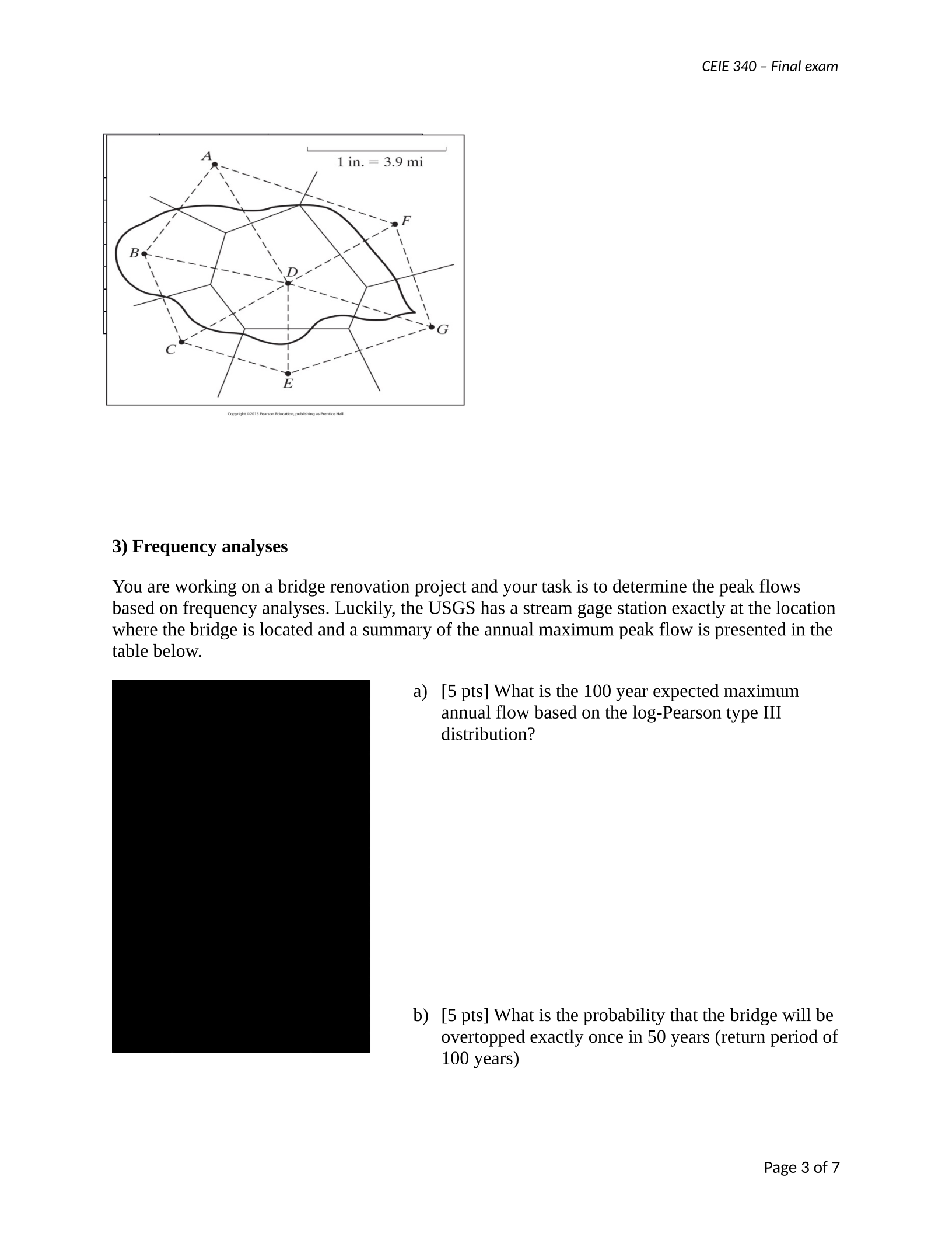
1) [5 pts] The location of 7 rain gages is showed in the figure below. Your colleagues in the GIS
department performed the Thiessen polygon analyses for your watershed including these rain
gages and calculated the respective areas of influence for each station within the watershed.
Calculate the average spatial precipitation for the watershed based on the gage measured values
given on the table below. How would the result be different using arithmetic average?
Page 2 of 7
CEIE 340 – Final exam
Gag
e
Area
(acres)
Rainfall depth
(in)
A 2.5 3.4
B 8 8.0
C 5 4.2
D 3.2 1.2
E 7.8 2.5
F 6.3 7.2
G 5 2.3
3) Frequency analyses
You are working on a bridge renovation project and your task is to determine the peak flows
based on frequency analyses. Luckily, the USGS has a stream gage station exactly at the location
where the bridge is located and a summary of the annual maximum peak flow is presented in the
table below.
a) [5 pts] What is the 100 year expected maximum
annual flow based on the log-Pearson type III
distribution?
b) [5 pts] What is the probability that the bridge will be
overtopped exactly once in 50 years (return period of
100 years)
Page 3 of 7
CEIE 340 – Final exam
4) Hydrological design
a) [5 pts] You are asked to design a project considering 100 years of return period and 6
hours of rainfall duration. Provide the hyetograph for the design storm based on the IDF
curve provided and the SCS type II distribution.
b) [5 pts] Considering a design storm with duration of 6 hours and return period of 100
years: Calculate the effective precipitation based on the SCS method for the watershed
conditions below:
Table 4: Watershed land use
Land use Soil Type Area (mi2)
Industrial districts A 8
Open spaces / Good condition D 3
Streets - Gravel B 2
Commercial C 5
Page 4 of 7
CEIE 340 – Final exam
c) [5 pts] Determine the soil infiltration capacity using the Horton Equation given that the
soil initial infiltration rate is equal to 4.8 in/hr and the final capacity is 1.6 in/hr for the
following times: t=1hr, 2hr, 3hr, 4hr, 5hr and 6 hr. You may assume a time constant k =
0.38/hr.
d) [5 pts] Calculate to total amount of water available for runoff based on your design
hyetograph (a) and the Horton Infiltration method (c). Quantify the difference between
the SCS method and the Horton method.
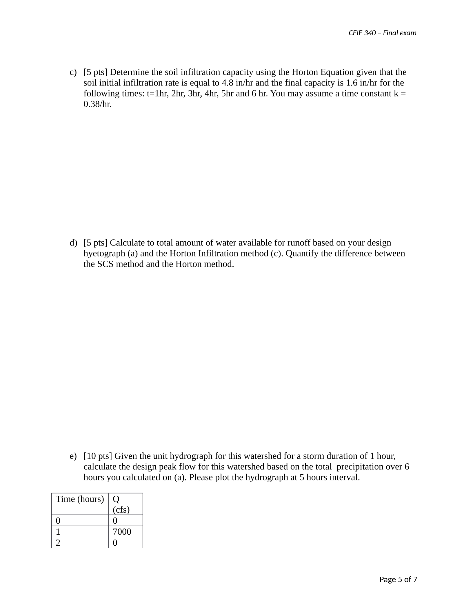
e) [10 pts] Given the unit hydrograph for this watershed for a storm duration of 1 hour,
calculate the design peak flow for this watershed based on the total precipitation over 6
hours you calculated on (a). Please plot the hydrograph at 5 hours interval.
Time (hours) Q
(cfs)
0 0
1 7000
2 0
Page 5 of 7

CEIE 340 – Final exam
g) ) [10 pts] You are responsible for designing the new development of a large shopping and
industrial complex. The local community has risen concerned about the impacts on flooding due
the new development. The County Storm Water Engineer has asked you to quantify the impact
of your project on the watershed peak flow and requires the use of the Rational Method. The
watershed area is 5 mi2, typical soil conditions in the area is group B and the current land cover
condition is: 60% forests (grass cover on 80% of the area), 20% Apartments, and 10% industrial
district. The new development will occupy 50% of the watershed and will be located in the
forested areas. The development land use will be 60% industrial and 40% apartments. The
average slope in the watershed is currently 110 ft/mi and due to cut and fill operations will
change to 80 ft/mi after the development. Use rainfall duration of 3 hours for your analyses and
a 50 year design storm. The length to divide in the watershed is 1.5 mile. Please present the
current peak flow for the 50 year return period. The future peak flow and the amount of peak
flow to be mitigated by storm water management strategies. Suggest at least 1 potential
mitigation strategy. Be conservative when choosing your parameters.
Page 7 of 7
Powered by TCPDF (www.tcpdf.org)

