


Hydrology Methods: Flood Risk Management

Methods
The adoption and diffusion of decision support technology, with application to flood risk
management in Victoria, signify the conceptual basis for this thesis. Digital spatial information
modelling and the integration of the data and information used in the decision-support system
illustrate the technical basis of the paper.
In this research, the relevant data and information were gathered and analysed by the
application of a case study approach. As it was noticed by Serrao-Neumann et al. (2013), the
contextual analyses allow the researcher to look at natural phenomena in their typical setting
and use the information acquired by various methods and sources. Multiple disciplines, from
research on information systems operation, apply learning based on cases (Rajabifard et al.
2002, Mohammadi 2008, McDougall 2006). According to the previously mentioned scholars,
a case study approach is immensely suitable for investigation of the information systems field
because this filed continually innovates and undergoes changes (Rajabifard et al. 2002,
Mohammadi 2008, McDougall 2006).
Yin (2003) believes that when the phenomenon under study is identical to its context, the case
study research method also could be used. For instance, the complex interactions between
advanced technologies and organisations illustrate these circumstances. Hence, case study
research methods signify that the researcher asks “how and why” questions, focuses on the
contemporary phenomenon within a real-life context, and has the little opportunity to control
the events. Therefore, the application of contextual analyses is the most appropriate when the
investigator broadly defines research topics and covers not simply disengaged factors but
contextual or complex multivariate conditions (Yin 2003). Furthermore, according to Yin
(2003), it is essential to use opinions of the technology to understand the actual uses of the
technology and potential difficulties being faced by adopters if a case study refers to such
innovation as digital spatial information and enabling knowledge. The author of the current
research was an employee in the City of Whittlesea (CoW), and this experience allowed him
to make observations at the augmented level and investigate the dynamics of surrounding
organisational behaviour of the stakeholders towards enabling technology and geospatial data
(Yin 2003).
Figure 1.1 reflects the research design of the project that unites a framework for information
systems case study research approaches as it was described by Kaplan and Duchon (1988),
Lee and Heaney (2003), Onsrud et al. (1992) and Yin (2003). The first stage of the research

design is comprised of the detailed project formulation, including reviewing of the relevant
theory and practice that provides the foundation for the further improvement of an appropriate
theoretical framework for data collection and evaluation. This is possible due to the utilisation
of data and information collected through mixed research methods used at the second stage.
The third stage uses data and information gathered at the preceding step of the research. These
materials were obtained in the result of the development of a suite of flood management (FM)
stakeholder needs-focussed geospatial tools for the implementation within the Victorian FM
program. FM program created for Victoria is universal and, therefore, could be adapted to
other national and world-wide FM programs.
The data and information that were obtained during the first two stages are used for further
investigation at the third stage of the research. The outputs of the first three steps form the
fourth stage that includes the conclusions and recommendations of this thesis.
Figure 1.1: Proposed research design.
The final conclusions and recommendations of the present research paper will be based on the
synthesis and analysis of the first, second, and thirds stages. The first two stages present
information on the of a GIS-embedded hydrological model with machine learning techniques,
to improve administrative practices informed by flood hazard modelling. This information

includes a review of literature dedicated to the floodplain management in the Victoria setting.
Apart from that, it also consists of the user needs of spatial analysis and the concept of
hydrological modelling using Light Detection and Ranging (LiDAR).
The discussion presented in the third and fourth stages highlights the following topics:
• GIS functionalities in hydrological modelling and LiDAR data implementation for the
Victorian Council’s flood model;
• The importance of the spatial database for “on-request” hydrological modelling;
• Flood modelling through an examination of GIS datasets to detect the gaps in spatial
information and the essential characteristics;
• GIS in Water Resources with machine learning and Flood Risk Management;
Data used at the first and the second stages of the research focuses on flooding and floodplain
management in the Australian settings. The utilisation of LiDAR enables users to perform a
spatial investigation and a reasonable hydrological visualisation. The examination of GIS
functionalities in hydrological and LiDAR applications conducted at the third and fourth stages
shows the effects along the Victorian creek. These stages investigate the importance of GIS
database for ‘on-request’ hydrological examination and flood modelling over the use of spatial
datasets. This investigation allows to reveal the gaps in GIS information and indicate the
required characteristics of hydrology models for flood modelling. As a result, the fourth stage
will address the central problem of the present research and its objectives.
The knowledge gained from this project could be used to inform future FM and provide spatial
information infrastructure (SII) policy reforms in Victoria. Additionally, the results of the
research might close the previously mentioned policy-to-practice gaps related to the integration
of spatial decision-support for FM in Victoria.
Structure and Outline of the Thesis
Figure 1.2, presented below, reflect the structure of the thesis that is comprised of eight
chapters.

Figure 1.2: Structure of the thesis in relation to the objectives and research questions.
As it has already been stated, the first stage of the research is comprised of research
formulation, literature review and development of the strategy. Chapter 1 includes the
introduction and the theoretical framework of the thesis. It also described the problem, aim,
and questions of the research. The literature review on flooding, flood management, GIS and
Hydrological modelling could be found in Chapter 2 that answers the first and the second
research questions.
The second stage includes the case studies and the pilot study area that are described in chapter
3 “Pilot study area: City of Whittlesea (CoW)”. This section explains the standards for choosing
the pilot study area (the CoW) and hydrological and associated qualities of this area.
The focus of the third step of the thesis is directed at GIS data structures and processes for
integrating GIS with hydrological modelling. Therefore, chapter 4 discusses a case study aimed
at floodplain delineation using ArcHydro models, the choice of methods and user data
information needs in the context of local flood-risk analysis. It depicts the strategies and result
of spatial information linking for extricating overland flow through the property and reduces
the risk of flash flooding area utilizing GIS-embedded hydrological model with machine
learning techniques. In this chapter, the author also discusses the limitations in existing local
flood relevant spatial databases and answers the first and the third research questions.

Chapter 5 includes a case study on the watershed delineation of flood risk zones through
ArcSwat. The numerical models, introduced in this chapter, can simulate hydrological
processes by ArcSWAT. This chapter answers the research questions one and three.
Stage four involves GIS design and development for flood support of climate change tools.
Chapter 6 that is a case study on finding areas at risk of flooding in a downpour, presents the
results of the fourth step. This chapter applies the DEM dataset in GIS-embedded hydrological
model with machine learning techniques and answers the fourth and the fifth research
questions.
The penultimate stage of the thesis paper reveals the outcomes, flood scenarios and
infrastructure risk tools. Chapter 6 is comprised of a case study which develops an approach
for identifying infrastructure at risk from flooding, LiDAR modelling of flood inundation under
future and describes the current and future threats to infrastructure. Since chapter 7 is dedicated
to the discussion of GIS, remote sensing, and machine learning, it highlights the correlation
between the land-use changes and flash-flood potential. Chapter 7 answers the sixth research
questions.
The objective of the final stage of the research is to present conclusions and recommendations.
Chapter 8 that is the synthesis of findings, contains the results of this stage, conclusions and
recommendations for future research for improving Victoria’s flood management. In addition,
the last chapter provides suggestions for future research. Chapter 8 addresses the problem and
primary research objectives as well as the ways for future research.
Scope and the Key Assumptions of the Research
Undoubtedly, “spatial industry” faces certain limitations in term of the implementation of
policies directed at the mitigation of climate change (Douglas et al. 2008). This is illustrated
by the consequences of flood management practices used in Victoria in 2016. Thus, the critical
assumption of the research is that the modern models of floods have the capability to make
predictions only about urban areas. Furthermore, DEM datasets regard urban landscapes as a
stable during the whole time of the disaster. The conclusions that were reached in the fourth,
fifth, sixth and seventh chapters of the paper depict that it would be more beneficial to use
different tools to estimate the impact that floods would cause for infrastructural objects. The
sections from fourth to seventh bring novelty to the scientific community since the bridge the
gap of the limited research on simulation of floods impact on infrastructure.

Most importantly, there is no other research that would build an investigation of
interdependencies between flash-flood potential and land-use changes upon the combination
of GIS and hydrology model with machine learning. At the same time, it must be admitted that
the area that was used for the analysis in the paper was not affected by a flood. Nevertheless,
despite this fact, the presented procedure is universal and, consequently, could be applied in
any other area without exceptions.
Summary
The first chapter formulates the scientific and practical values of the research, its aims,
objectives, structure and could be viewed as the framework and the foundation for the
subsequent chapters. The second chapter reviews the literature on such topics as GIS,
hydrology, and information models that are applied for the analysis. The following four
sections describe the case study and by formulating the results not only answer the research
question but also bring novelty to the issued field of research.
Methods
The adoption and diffusion of decision support technology, with application to flood risk
management in Victoria, signify the conceptual basis for this thesis. Digital spatial information
modelling and the integration of the data and information used in the decision-support system
illustrate the technical basis of the paper.
In this research, the relevant data and information were gathered and analysed by the
application of a case study approach. As it was noticed by Serrao-Neumann et al. (2013), the
contextual analyses allow the researcher to look at natural phenomena in their typical setting
and use the information acquired by various methods and sources. Multiple disciplines, from
research on information systems operation, apply learning based on cases (Rajabifard et al.
2002, Mohammadi 2008, McDougall 2006). According to the previously mentioned scholars,
a case study approach is immensely suitable for investigation of the information systems field
because this filed continually innovates and undergoes changes (Rajabifard et al. 2002,
Mohammadi 2008, McDougall 2006).
Yin (2003) believes that when the phenomenon under study is identical to its context, the case
study research method also could be used. For instance, the complex interactions between
advanced technologies and organisations illustrate these circumstances. Hence, case study
research methods signify that the researcher asks “how and why” questions, focuses on the

contemporary phenomenon within a real-life context, and has the little opportunity to control
the events. Therefore, the application of contextual analyses is the most appropriate when the
investigator broadly defines research topics and covers not simply disengaged factors but
contextual or complex multivariate conditions (Yin 2003). Furthermore, according to Yin
(2003), it is essential to use opinions of the technology to understand the actual uses of the
technology and potential difficulties being faced by adopters if a case study refers to such
innovation as digital spatial information and enabling knowledge. The author of the current
research was an employee in the City of Whittlesea (CoW), and this experience allowed him
to make observations at the augmented level and investigate the dynamics of surrounding
organisational behaviour of the stakeholders towards enabling technology and geospatial data
(Yin 2003).
Figure 1.1 reflects the research design of the project that unites a framework for information
systems case study research approaches as it was described by Kaplan and Duchon (1988),
Lee and Heaney (2003), Onsrud et al. (1992) and Yin (2003). The first stage of the research
design is comprised of the detailed project formulation, including reviewing of the relevant
theory and practice that provides the foundation for the further improvement of an appropriate
theoretical framework for data collection and evaluation. This is possible due to the utilisation
of data and information collected through mixed research methods used at the second stage.
The third stage uses data and information gathered at the preceding step of the research. These
materials were obtained in the result of the development of a suite of flood management (FM)
stakeholder needs-focussed geospatial tools for the implementation within the Victorian FM
program. FM program created for Victoria is universal and, therefore, could be adapted to
other national and world-wide FM programs.
The data and information that were obtained during the first two stages are used for further
investigation at the third stage of the research. The outputs of the first three steps form the
fourth stage that includes the conclusions and recommendations of this thesis.

Figure 1.1: Proposed research design.
The final conclusions and recommendations of the present research paper will be based on the
synthesis and analysis of the first, second, and thirds stages. The first two stages present
information on the of a GIS-embedded hydrological model with machine learning techniques,
to improve administrative practices informed by flood hazard modelling. This information
includes a review of literature dedicated to the floodplain management in the Victoria setting.
Apart from that, it also consists of the user needs of spatial analysis and the concept of
hydrological modelling using Light Detection and Ranging (LiDAR).
The discussion presented in the third and fourth stages highlights the following topics:
• GIS functionalities in hydrological modelling and LiDAR data implementation for the
Victorian Council’s flood model;
• The importance of the spatial database for “on-request” hydrological modelling;
• Flood modelling through an examination of GIS datasets to detect the gaps in spatial
information and the essential characteristics;
• GIS in Water Resources with machine learning and Flood Risk Management;

Data used at the first and the second stages of the research focuses on flooding and floodplain
management in the Australian settings. The utilisation of LiDAR enables users to perform a
spatial investigation and a reasonable hydrological visualisation. The examination of GIS
functionalities in hydrological and LiDAR applications conducted at the third and fourth stages
shows the effects along the Victorian creek. These stages investigate the importance of GIS
database for ‘on-request’ hydrological examination and flood modelling over the use of spatial
datasets. This investigation allows to reveal the gaps in GIS information and indicate the
required characteristics of hydrology models for flood modelling. As a result, the fourth stage
will address the central problem of the present research and its objectives.
The knowledge gained from this project could be used to inform future FM and provide spatial
information infrastructure (SII) policy reforms in Victoria. Additionally, the results of the
research might close the previously mentioned policy-to-practice gaps related to the integration
of spatial decision-support for FM in Victoria.
Structure and Outline of the Thesis
Figure 1.2, presented below, reflect the structure of the thesis that is comprised of eight
chapters.
Figure 1.2: Structure of the thesis in relation to the objectives and research questions.

As it has already been stated, the first stage of the research is comprised of research
formulation, literature review and development of the strategy. Chapter 1 includes the
introduction and the theoretical framework of the thesis. It also described the problem, aim,
and questions of the research. The literature review on flooding, flood management, GIS and
Hydrological modelling could be found in Chapter 2 that answers the first and the second
research questions.
The second stage includes the case studies and the pilot study area that are described in chapter
3 “Pilot study area: City of Whittlesea (CoW)”. This section explains the standards for choosing
the pilot study area (the CoW) and hydrological and associated qualities of this area.
The focus of the third step of the thesis is directed at GIS data structures and processes for
integrating GIS with hydrological modelling. Therefore, chapter 4 discusses a case study aimed
at floodplain delineation using ArcHydro models, the choice of methods and user data
information needs in the context of local flood-risk analysis. It depicts the strategies and result
of spatial information linking for extricating overland flow through the property and reduces
the risk of flash flooding area utilizing GIS-embedded hydrological model with machine
learning techniques. In this chapter, the author also discusses the limitations in existing local
flood relevant spatial databases and answers the first and the third research questions.
Chapter 5 includes a case study on the watershed delineation of flood risk zones through
ArcSwat. The numerical models, introduced in this chapter, can simulate hydrological
processes by ArcSWAT. This chapter answers the research questions one and three.
Stage four involves GIS design and development for flood support of climate change tools.
Chapter 6 that is a case study on finding areas at risk of flooding in a downpour, presents the
results of the fourth step. This chapter applies the DEM dataset in GIS-embedded hydrological
model with machine learning techniques and answers the fourth and the fifth research
questions.
The penultimate stage of the thesis paper reveals the outcomes, flood scenarios and
infrastructure risk tools. Chapter 6 is comprised of a case study which develops an approach
for identifying infrastructure at risk from flooding, LiDAR modelling of flood inundation under
future and describes the current and future threats to infrastructure. Since chapter 7 is dedicated
to the discussion of GIS, remote sensing, and machine learning, it highlights the correlation
between the land-use changes and flash-flood potential. Chapter 7 answers the sixth research
questions.

The objective of the final stage of the research is to present conclusions and recommendations.
Chapter 8 that is the synthesis of findings, contains the results of this stage, conclusions and
recommendations for future research for improving Victoria’s flood management. In addition,
the last chapter provides suggestions for future research. Chapter 8 addresses the problem and
primary research objectives as well as the ways for future research.
Scope and the Key Assumptions of the Research
Undoubtedly, “spatial industry” faces certain limitations in term of the implementation of
policies directed at the mitigation of climate change (Douglas et al. 2008). This is illustrated
by the consequences of flood management practices used in Victoria in 2016. Thus, the critical
assumption of the research is that the modern models of floods have the capability to make
predictions only about urban areas. Furthermore, DEM datasets regard urban landscapes as a
stable during the whole time of the disaster. The conclusions that were reached in the fourth,
fifth, sixth and seventh chapters of the paper depict that it would be more beneficial to use
different tools to estimate the impact that floods would cause for infrastructural objects. The
sections from fourth to seventh bring novelty to the scientific community since the bridge the
gap of the limited research on simulation of floods impact on infrastructure.
Most importantly, there is no other research that would build an investigation of
interdependencies between flash-flood potential and land-use changes upon the combination
of GIS and hydrology model with machine learning. At the same time, it must be admitted that
the area that was used for the analysis in the paper was not affected by a flood. Nevertheless,
despite this fact, the presented procedure is universal and, consequently, could be applied in
any other area without exceptions.
Summary
The first chapter formulates the scientific and practical values of the research, its aims,
objectives, structure and could be viewed as the framework and the foundation for the
subsequent chapters. The second chapter reviews the literature on such topics as GIS,
hydrology, and information models that are applied for the analysis. The following four
sections describe the case study and by formulating the results not only answer the research
question but also bring novelty to the issued field of research.
Methods

The adoption and diffusion of decision support technology, with application to flood risk
management in Victoria, signify the conceptual basis for this thesis. Digital spatial information
modelling and the integration of the data and information used in the decision-support system
illustrate the technical basis of the paper.
In this research, the relevant data and information were gathered and analysed by the
application of a case study approach. As it was noticed by Serrao-Neumann et al. (2013), the
contextual analyses allow the researcher to look at natural phenomena in their typical setting
and use the information acquired by various methods and sources. Multiple disciplines, from
research on information systems operation, apply learning based on cases (Rajabifard et al.
2002, Mohammadi 2008, McDougall 2006). According to the previously mentioned scholars,
a case study approach is immensely suitable for investigation of the information systems field
because this filed continually innovates and undergoes changes (Rajabifard et al. 2002,
Mohammadi 2008, McDougall 2006).
Yin (2003) believes that when the phenomenon under study is identical to its context, the case
study research method also could be used. For instance, the complex interactions between
advanced technologies and organisations illustrate these circumstances. Hence, case study
research methods signify that the researcher asks “how and why” questions, focuses on the
contemporary phenomenon within a real-life context, and has the little opportunity to control
the events. Therefore, the application of contextual analyses is the most appropriate when the
investigator broadly defines research topics and covers not simply disengaged factors but
contextual or complex multivariate conditions (Yin 2003). Furthermore, according to Yin
(2003), it is essential to use opinions of the technology to understand the actual uses of the
technology and potential difficulties being faced by adopters if a case study refers to such
innovation as digital spatial information and enabling knowledge. The author of the current
research was an employee in the City of Whittlesea (CoW), and this experience allowed him
to make observations at the augmented level and investigate the dynamics of surrounding
organisational behaviour of the stakeholders towards enabling technology and geospatial data
(Yin 2003).
Figure 1.1 reflects the research design of the project that unites a framework for information
systems case study research approaches as it was described by Kaplan and Duchon (1988),
Lee and Heaney (2003), Onsrud et al. (1992) and Yin (2003). The first stage of the research
design is comprised of the detailed project formulation, including reviewing of the relevant

theory and practice that provides the foundation for the further improvement of an appropriate
theoretical framework for data collection and evaluation. This is possible due to the utilisation
of data and information collected through mixed research methods used at the second stage.
The third stage uses data and information gathered at the preceding step of the research. These
materials were obtained in the result of the development of a suite of flood management (FM)
stakeholder needs-focussed geospatial tools for the implementation within the Victorian FM
program. FM program created for Victoria is universal and, therefore, could be adapted to
other national and world-wide FM programs.
The data and information that were obtained during the first two stages are used for further
investigation at the third stage of the research. The outputs of the first three steps form the
fourth stage that includes the conclusions and recommendations of this thesis.
Figure 1.1: Proposed research design.
The final conclusions and recommendations of the present research paper will be based on the
synthesis and analysis of the first, second, and thirds stages. The first two stages present
information on the of a GIS-embedded hydrological model with machine learning techniques,
to improve administrative practices informed by flood hazard modelling. This information
includes a review of literature dedicated to the floodplain management in the Victoria setting.

Apart from that, it also consists of the user needs of spatial analysis and the concept of
hydrological modelling using Light Detection and Ranging (LiDAR).
The discussion presented in the third and fourth stages highlights the following topics:
• GIS functionalities in hydrological modelling and LiDAR data implementation for the
Victorian Council’s flood model;
• The importance of the spatial database for “on-request” hydrological modelling;
• Flood modelling through an examination of GIS datasets to detect the gaps in spatial
information and the essential characteristics;
• GIS in Water Resources with machine learning and Flood Risk Management;
Data used at the first and the second stages of the research focuses on flooding and floodplain
management in the Australian settings. The utilisation of LiDAR enables users to perform a
spatial investigation and a reasonable hydrological visualisation. The examination of GIS
functionalities in hydrological and LiDAR applications conducted at the third and fourth stages
shows the effects along the Victorian creek. These stages investigate the importance of GIS
database for ‘on-request’ hydrological examination and flood modelling over the use of spatial
datasets. This investigation allows to reveal the gaps in GIS information and indicate the
required characteristics of hydrology models for flood modelling. As a result, the fourth stage
will address the central problem of the present research and its objectives.
The knowledge gained from this project could be used to inform future FM and provide spatial
information infrastructure (SII) policy reforms in Victoria. Additionally, the results of the
research might close the previously mentioned policy-to-practice gaps related to the integration
of spatial decision-support for FM in Victoria.
Structure and Outline of the Thesis
Figure 1.2, presented below, reflect the structure of the thesis that is comprised of eight
chapters.

Figure 1.2: Structure of the thesis in relation to the objectives and research questions.
As it has already been stated, the first stage of the research is comprised of research
formulation, literature review and development of the strategy. Chapter 1 includes the
introduction and the theoretical framework of the thesis. It also described the problem, aim,
and questions of the research. The literature review on flooding, flood management, GIS and
Hydrological modelling could be found in Chapter 2 that answers the first and the second
research questions.
The second stage includes the case studies and the pilot study area that are described in chapter
3 “Pilot study area: City of Whittlesea (CoW)”. This section explains the standards for choosing
the pilot study area (the CoW) and hydrological and associated qualities of this area.
The focus of the third step of the thesis is directed at GIS data structures and processes for
integrating GIS with hydrological modelling. Therefore, chapter 4 discusses a case study aimed
at floodplain delineation using ArcHydro models, the choice of methods and user data
information needs in the context of local flood-risk analysis. It depicts the strategies and result
of spatial information linking for extricating overland flow through the property and reduces
the risk of flash flooding area utilizing GIS-embedded hydrological model with machine
learning techniques. In this chapter, the author also discusses the limitations in existing local
flood relevant spatial databases and answers the first and the third research questions.

Chapter 5 includes a case study on the watershed delineation of flood risk zones through
ArcSwat. The numerical models, introduced in this chapter, can simulate hydrological
processes by ArcSWAT. This chapter answers the research questions one and three.
Stage four involves GIS design and development for flood support of climate change tools.
Chapter 6 that is a case study on finding areas at risk of flooding in a downpour, presents the
results of the fourth step. This chapter applies the DEM dataset in GIS-embedded hydrological
model with machine learning techniques and answers the fourth and the fifth research
questions.
The penultimate stage of the thesis paper reveals the outcomes, flood scenarios and
infrastructure risk tools. Chapter 6 is comprised of a case study which develops an approach
for identifying infrastructure at risk from flooding, LiDAR modelling of flood inundation under
future and describes the current and future threats to infrastructure. Since chapter 7 is dedicated
to the discussion of GIS, remote sensing, and machine learning, it highlights the correlation
between the land-use changes and flash-flood potential. Chapter 7 answers the sixth research
questions.
The objective of the final stage of the research is to present conclusions and recommendations.
Chapter 8 that is the synthesis of findings, contains the results of this stage, conclusions and
recommendations for future research for improving Victoria’s flood management. In addition,
the last chapter provides suggestions for future research. Chapter 8 addresses the problem and
primary research objectives as well as the ways for future research.
Scope and the Key Assumptions of the Research
Undoubtedly, “spatial industry” faces certain limitations in term of the implementation of
policies directed at the mitigation of climate change (Douglas et al. 2008). This is illustrated
by the consequences of flood management practices used in Victoria in 2016. Thus, the critical
assumption of the research is that the modern models of floods have the capability to make
predictions only about urban areas. Furthermore, DEM datasets regard urban landscapes as a
stable during the whole time of the disaster. The conclusions that were reached in the fourth,
fifth, sixth and seventh chapters of the paper depict that it would be more beneficial to use
different tools to estimate the impact that floods would cause for infrastructural objects. The
sections from fourth to seventh bring novelty to the scientific community since the bridge the
gap of the limited research on simulation of floods impact on infrastructure.

Most importantly, there is no other research that would build an investigation of
interdependencies between flash-flood potential and land-use changes upon the combination
of GIS and hydrology model with machine learning. At the same time, it must be admitted that
the area that was used for the analysis in the paper was not affected by a flood. Nevertheless,
despite this fact, the presented procedure is universal and, consequently, could be applied in
any other area without exceptions.
Summary
The first chapter formulates the scientific and practical values of the research, its aims,
objectives, structure and could be viewed as the framework and the foundation for the
subsequent chapters. The second chapter reviews the literature on such topics as GIS,
hydrology, and information models that are applied for the analysis. The following four
sections describe the case study and by formulating the results not only answer the research
question but also bring novelty to the issued field of research.
Methods
The adoption and diffusion of decision support technology, with application to flood risk
management in Victoria, signify the conceptual basis for this thesis. Digital spatial information
modelling and the integration of the data and information used in the decision-support system
illustrate the technical basis of the paper.
In this research, the relevant data and information were gathered and analysed by the
application of a case study approach. As it was noticed by Serrao-Neumann et al. (2013), the
contextual analyses allow the researcher to look at natural phenomena in their typical setting
and use the information acquired by various methods and sources. Multiple disciplines, from
research on information systems operation, apply learning based on cases (Rajabifard et al.
2002, Mohammadi 2008, McDougall 2006). According to the previously mentioned scholars,
a case study approach is immensely suitable for investigation of the information systems field
because this filed continually innovates and undergoes changes (Rajabifard et al. 2002,
Mohammadi 2008, McDougall 2006).
Yin (2003) believes that when the phenomenon under study is identical to its context, the case
study research method also could be used. For instance, the complex interactions between
advanced technologies and organisations illustrate these circumstances. Hence, case study
research methods signify that the researcher asks “how and why” questions, focuses on the

contemporary phenomenon within a real-life context, and has the little opportunity to control
the events. Therefore, the application of contextual analyses is the most appropriate when the
investigator broadly defines research topics and covers not simply disengaged factors but
contextual or complex multivariate conditions (Yin 2003). Furthermore, according to Yin
(2003), it is essential to use opinions of the technology to understand the actual uses of the
technology and potential difficulties being faced by adopters if a case study refers to such
innovation as digital spatial information and enabling knowledge. The author of the current
research was an employee in the City of Whittlesea (CoW), and this experience allowed him
to make observations at the augmented level and investigate the dynamics of surrounding
organisational behaviour of the stakeholders towards enabling technology and geospatial data
(Yin 2003).
Figure 1.1 reflects the research design of the project that unites a framework for information
systems case study research approaches as it was described by Kaplan and Duchon (1988),
Lee and Heaney (2003), Onsrud et al. (1992) and Yin (2003). The first stage of the research
design is comprised of the detailed project formulation, including reviewing of the relevant
theory and practice that provides the foundation for the further improvement of an appropriate
theoretical framework for data collection and evaluation. This is possible due to the utilisation
of data and information collected through mixed research methods used at the second stage.
The third stage uses data and information gathered at the preceding step of the research. These
materials were obtained in the result of the development of a suite of flood management (FM)
stakeholder needs-focussed geospatial tools for the implementation within the Victorian FM
program. FM program created for Victoria is universal and, therefore, could be adapted to
other national and world-wide FM programs.
The data and information that were obtained during the first two stages are used for further
investigation at the third stage of the research. The outputs of the first three steps form the
fourth stage that includes the conclusions and recommendations of this thesis.

Figure 1.1: Proposed research design.
The final conclusions and recommendations of the present research paper will be based on the
synthesis and analysis of the first, second, and thirds stages. The first two stages present
information on the of a GIS-embedded hydrological model with machine learning techniques,
to improve administrative practices informed by flood hazard modelling. This information
includes a review of literature dedicated to the floodplain management in the Victoria setting.
Apart from that, it also consists of the user needs of spatial analysis and the concept of
hydrological modelling using Light Detection and Ranging (LiDAR).
The discussion presented in the third and fourth stages highlights the following topics:
• GIS functionalities in hydrological modelling and LiDAR data implementation for the
Victorian Council’s flood model;
• The importance of the spatial database for “on-request” hydrological modelling;
• Flood modelling through an examination of GIS datasets to detect the gaps in spatial
information and the essential characteristics;
• GIS in Water Resources with machine learning and Flood Risk Management;

Data used at the first and the second stages of the research focuses on flooding and floodplain
management in the Australian settings. The utilisation of LiDAR enables users to perform a
spatial investigation and a reasonable hydrological visualisation. The examination of GIS
functionalities in hydrological and LiDAR applications conducted at the third and fourth stages
shows the effects along the Victorian creek. These stages investigate the importance of GIS
database for ‘on-request’ hydrological examination and flood modelling over the use of spatial
datasets. This investigation allows to reveal the gaps in GIS information and indicate the
required characteristics of hydrology models for flood modelling. As a result, the fourth stage
will address the central problem of the present research and its objectives.
The knowledge gained from this project could be used to inform future FM and provide spatial
information infrastructure (SII) policy reforms in Victoria. Additionally, the results of the
research might close the previously mentioned policy-to-practice gaps related to the integration
of spatial decision-support for FM in Victoria.
Structure and Outline of the Thesis
Figure 1.2, presented below, reflect the structure of the thesis that is comprised of eight
chapters.
Figure 1.2: Structure of the thesis in relation to the objectives and research questions.

As it has already been stated, the first stage of the research is comprised of research
formulation, literature review and development of the strategy. Chapter 1 includes the
introduction and the theoretical framework of the thesis. It also described the problem, aim,
and questions of the research. The literature review on flooding, flood management, GIS and
Hydrological modelling could be found in Chapter 2 that answers the first and the second
research questions.
The second stage includes the case studies and the pilot study area that are described in chapter
3 “Pilot study area: City of Whittlesea (CoW)”. This section explains the standards for choosing
the pilot study area (the CoW) and hydrological and associated qualities of this area.
The focus of the third step of the thesis is directed at GIS data structures and processes for
integrating GIS with hydrological modelling. Therefore, chapter 4 discusses a case study aimed
at floodplain delineation using ArcHydro models, the choice of methods and user data
information needs in the context of local flood-risk analysis. It depicts the strategies and result
of spatial information linking for extricating overland flow through the property and reduces
the risk of flash flooding area utilizing GIS-embedded hydrological model with machine
learning techniques. In this chapter, the author also discusses the limitations in existing local
flood relevant spatial databases and answers the first and the third research questions.
Chapter 5 includes a case study on the watershed delineation of flood risk zones through
ArcSwat. The numerical models, introduced in this chapter, can simulate hydrological
processes by ArcSWAT. This chapter answers the research questions one and three.
Stage four involves GIS design and development for flood support of climate change tools.
Chapter 6 that is a case study on finding areas at risk of flooding in a downpour, presents the
results of the fourth step. This chapter applies the DEM dataset in GIS-embedded hydrological
model with machine learning techniques and answers the fourth and the fifth research
questions.
The penultimate stage of the thesis paper reveals the outcomes, flood scenarios and
infrastructure risk tools. Chapter 6 is comprised of a case study which develops an approach
for identifying infrastructure at risk from flooding, LiDAR modelling of flood inundation under
future and describes the current and future threats to infrastructure. Since chapter 7 is dedicated
to the discussion of GIS, remote sensing, and machine learning, it highlights the correlation
between the land-use changes and flash-flood potential. Chapter 7 answers the sixth research
questions.

The objective of the final stage of the research is to present conclusions and recommendations.
Chapter 8 that is the synthesis of findings, contains the results of this stage, conclusions and
recommendations for future research for improving Victoria’s flood management. In addition,
the last chapter provides suggestions for future research. Chapter 8 addresses the problem and
primary research objectives as well as the ways for future research.
Scope and the Key Assumptions of the Research
Undoubtedly, “spatial industry” faces certain limitations in term of the implementation of
policies directed at the mitigation of climate change (Douglas et al. 2008). This is illustrated
by the consequences of flood management practices used in Victoria in 2016. Thus, the critical
assumption of the research is that the modern models of floods have the capability to make
predictions only about urban areas. Furthermore, DEM datasets regard urban landscapes as a
stable during the whole time of the disaster. The conclusions that were reached in the fourth,
fifth, sixth and seventh chapters of the paper depict that it would be more beneficial to use
different tools to estimate the impact that floods would cause for infrastructural objects. The
sections from fourth to seventh bring novelty to the scientific community since the bridge the
gap of the limited research on simulation of floods impact on infrastructure.
Most importantly, there is no other research that would build an investigation of
interdependencies between flash-flood potential and land-use changes upon the combination
of GIS and hydrology model with machine learning. At the same time, it must be admitted that
the area that was used for the analysis in the paper was not affected by a flood. Nevertheless,
despite this fact, the presented procedure is universal and, consequently, could be applied in
any other area without exceptions.
Summary
The first chapter formulates the scientific and practical values of the research, its aims,
objectives, structure and could be viewed as the framework and the foundation for the
subsequent chapters. The second chapter reviews the literature on such topics as GIS,
hydrology, and information models that are applied for the analysis. The following four
sections describe the case study and by formulating the results not only answer the research
question but also bring novelty to the issued field of research.
Methods

The adoption and diffusion of decision support technology, with application to flood risk
management in Victoria, signify the conceptual basis for this thesis. Digital spatial information
modelling and the integration of the data and information used in the decision-support system
illustrate the technical basis of the paper.
In this research, the relevant data and information were gathered and analysed by the
application of a case study approach. As it was noticed by Serrao-Neumann et al. (2013), the
contextual analyses allow the researcher to look at natural phenomena in their typical setting
and use the information acquired by various methods and sources. Multiple disciplines, from
research on information systems operation, apply learning based on cases (Rajabifard et al.
2002, Mohammadi 2008, McDougall 2006). According to the previously mentioned scholars,
a case study approach is immensely suitable for investigation of the information systems field
because this filed continually innovates and undergoes changes (Rajabifard et al. 2002,
Mohammadi 2008, McDougall 2006).
Yin (2003) believes that when the phenomenon under study is identical to its context, the case
study research method also could be used. For instance, the complex interactions between
advanced technologies and organisations illustrate these circumstances. Hence, case study
research methods signify that the researcher asks “how and why” questions, focuses on the
contemporary phenomenon within a real-life context, and has the little opportunity to control
the events. Therefore, the application of contextual analyses is the most appropriate when the
investigator broadly defines research topics and covers not simply disengaged factors but
contextual or complex multivariate conditions (Yin 2003). Furthermore, according to Yin
(2003), it is essential to use opinions of the technology to understand the actual uses of the
technology and potential difficulties being faced by adopters if a case study refers to such
innovation as digital spatial information and enabling knowledge. The author of the current
research was an employee in the City of Whittlesea (CoW), and this experience allowed him
to make observations at the augmented level and investigate the dynamics of surrounding
organisational behaviour of the stakeholders towards enabling technology and geospatial data
(Yin 2003).
Figure 1.1 reflects the research design of the project that unites a framework for information
systems case study research approaches as it was described by Kaplan and Duchon (1988),
Lee and Heaney (2003), Onsrud et al. (1992) and Yin (2003). The first stage of the research
design is comprised of the detailed project formulation, including reviewing of the relevant

theory and practice that provides the foundation for the further improvement of an appropriate
theoretical framework for data collection and evaluation. This is possible due to the utilisation
of data and information collected through mixed research methods used at the second stage.
The third stage uses data and information gathered at the preceding step of the research. These
materials were obtained in the result of the development of a suite of flood management (FM)
stakeholder needs-focussed geospatial tools for the implementation within the Victorian FM
program. FM program created for Victoria is universal and, therefore, could be adapted to
other national and world-wide FM programs.
The data and information that were obtained during the first two stages are used for further
investigation at the third stage of the research. The outputs of the first three steps form the
fourth stage that includes the conclusions and recommendations of this thesis.
Figure 1.1: Proposed research design.
The final conclusions and recommendations of the present research paper will be based on the
synthesis and analysis of the first, second, and thirds stages. The first two stages present
information on the of a GIS-embedded hydrological model with machine learning techniques,
to improve administrative practices informed by flood hazard modelling. This information
includes a review of literature dedicated to the floodplain management in the Victoria setting.

Apart from that, it also consists of the user needs of spatial analysis and the concept of
hydrological modelling using Light Detection and Ranging (LiDAR).
The discussion presented in the third and fourth stages highlights the following topics:
• GIS functionalities in hydrological modelling and LiDAR data implementation for the
Victorian Council’s flood model;
• The importance of the spatial database for “on-request” hydrological modelling;
• Flood modelling through an examination of GIS datasets to detect the gaps in spatial
information and the essential characteristics;
• GIS in Water Resources with machine learning and Flood Risk Management;
Data used at the first and the second stages of the research focuses on flooding and floodplain
management in the Australian settings. The utilisation of LiDAR enables users to perform a
spatial investigation and a reasonable hydrological visualisation. The examination of GIS
functionalities in hydrological and LiDAR applications conducted at the third and fourth stages
shows the effects along the Victorian creek. These stages investigate the importance of GIS
database for ‘on-request’ hydrological examination and flood modelling over the use of spatial
datasets. This investigation allows to reveal the gaps in GIS information and indicate the
required characteristics of hydrology models for flood modelling. As a result, the fourth stage
will address the central problem of the present research and its objectives.
The knowledge gained from this project could be used to inform future FM and provide spatial
information infrastructure (SII) policy reforms in Victoria. Additionally, the results of the
research might close the previously mentioned policy-to-practice gaps related to the integration
of spatial decision-support for FM in Victoria.
Structure and Outline of the Thesis
Figure 1.2, presented below, reflect the structure of the thesis that is comprised of eight
chapters.

Figure 1.2: Structure of the thesis in relation to the objectives and research questions.
As it has already been stated, the first stage of the research is comprised of research
formulation, literature review and development of the strategy. Chapter 1 includes the
introduction and the theoretical framework of the thesis. It also described the problem, aim,
and questions of the research. The literature review on flooding, flood management, GIS and
Hydrological modelling could be found in Chapter 2 that answers the first and the second
research questions.
The second stage includes the case studies and the pilot study area that are described in chapter
3 “Pilot study area: City of Whittlesea (CoW)”. This section explains the standards for choosing
the pilot study area (the CoW) and hydrological and associated qualities of this area.
The focus of the third step of the thesis is directed at GIS data structures and processes for
integrating GIS with hydrological modelling. Therefore, chapter 4 discusses a case study aimed
at floodplain delineation using ArcHydro models, the choice of methods and user data
information needs in the context of local flood-risk analysis. It depicts the strategies and result
of spatial information linking for extricating overland flow through the property and reduces
the risk of flash flooding area utilizing GIS-embedded hydrological model with machine
learning techniques. In this chapter, the author also discusses the limitations in existing local
flood relevant spatial databases and answers the first and the third research questions.

Chapter 5 includes a case study on the watershed delineation of flood risk zones through
ArcSwat. The numerical models, introduced in this chapter, can simulate hydrological
processes by ArcSWAT. This chapter answers the research questions one and three.
Stage four involves GIS design and development for flood support of climate change tools.
Chapter 6 that is a case study on finding areas at risk of flooding in a downpour, presents the
results of the fourth step. This chapter applies the DEM dataset in GIS-embedded hydrological
model with machine learning techniques and answers the fourth and the fifth research
questions.
The penultimate stage of the thesis paper reveals the outcomes, flood scenarios and
infrastructure risk tools. Chapter 6 is comprised of a case study which develops an approach
for identifying infrastructure at risk from flooding, LiDAR modelling of flood inundation under
future and describes the current and future threats to infrastructure. Since chapter 7 is dedicated
to the discussion of GIS, remote sensing, and machine learning, it highlights the correlation
between the land-use changes and flash-flood potential. Chapter 7 answers the sixth research
questions.
The objective of the final stage of the research is to present conclusions and recommendations.
Chapter 8 that is the synthesis of findings, contains the results of this stage, conclusions and
recommendations for future research for improving Victoria’s flood management. In addition,
the last chapter provides suggestions for future research. Chapter 8 addresses the problem and
primary research objectives as well as the ways for future research.
Scope and the Key Assumptions of the Research
Undoubtedly, “spatial industry” faces certain limitations in term of the implementation of
policies directed at the mitigation of climate change (Douglas et al. 2008). This is illustrated
by the consequences of flood management practices used in Victoria in 2016. Thus, the critical
assumption of the research is that the modern models of floods have the capability to make
predictions only about urban areas. Furthermore, DEM datasets regard urban landscapes as a
stable during the whole time of the disaster. The conclusions that were reached in the fourth,
fifth, sixth and seventh chapters of the paper depict that it would be more beneficial to use
different tools to estimate the impact that floods would cause for infrastructural objects. The
sections from fourth to seventh bring novelty to the scientific community since the bridge the
gap of the limited research on simulation of floods impact on infrastructure.

Most importantly, there is no other research that would build an investigation of
interdependencies between flash-flood potential and land-use changes upon the combination
of GIS and hydrology model with machine learning. At the same time, it must be admitted that
the area that was used for the analysis in the paper was not affected by a flood. Nevertheless,
despite this fact, the presented procedure is universal and, consequently, could be applied in
any other area without exceptions.
Summary
The first chapter formulates the scientific and practical values of the research, its aims,
objectives, structure and could be viewed as the framework and the foundation for the
subsequent chapters. The second chapter reviews the literature on such topics as GIS,
hydrology, and information models that are applied for the analysis. The following four
sections describe the case study and by formulating the results not only answer the research
question but also bring novelty to the issued field of research.
Methods
The adoption and diffusion of decision support technology, with application to flood risk
management in Victoria, signify the conceptual basis for this thesis. Digital spatial information
modelling and the integration of the data and information used in the decision-support system
illustrate the technical basis of the paper.
In this research, the relevant data and information were gathered and analysed by the
application of a case study approach. As it was noticed by Serrao-Neumann et al. (2013), the
contextual analyses allow the researcher to look at natural phenomena in their typical setting
and use the information acquired by various methods and sources. Multiple disciplines, from
research on information systems operation, apply learning based on cases (Rajabifard et al.
2002, Mohammadi 2008, McDougall 2006). According to the previously mentioned scholars,
a case study approach is immensely suitable for investigation of the information systems field
because this filed continually innovates and undergoes changes (Rajabifard et al. 2002,
Mohammadi 2008, McDougall 2006).
Yin (2003) believes that when the phenomenon under study is identical to its context, the case
study research method also could be used. For instance, the complex interactions between
advanced technologies and organisations illustrate these circumstances. Hence, case study
research methods signify that the researcher asks “how and why” questions, focuses on the

contemporary phenomenon within a real-life context, and has the little opportunity to control
the events. Therefore, the application of contextual analyses is the most appropriate when the
investigator broadly defines research topics and covers not simply disengaged factors but
contextual or complex multivariate conditions (Yin 2003). Furthermore, according to Yin
(2003), it is essential to use opinions of the technology to understand the actual uses of the
technology and potential difficulties being faced by adopters if a case study refers to such
innovation as digital spatial information and enabling knowledge. The author of the current
research was an employee in the City of Whittlesea (CoW), and this experience allowed him
to make observations at the augmented level and investigate the dynamics of surrounding
organisational behaviour of the stakeholders towards enabling technology and geospatial data
(Yin 2003).
Figure 1.1 reflects the research design of the project that unites a framework for information
systems case study research approaches as it was described by Kaplan and Duchon (1988),
Lee and Heaney (2003), Onsrud et al. (1992) and Yin (2003). The first stage of the research
design is comprised of the detailed project formulation, including reviewing of the relevant
theory and practice that provides the foundation for the further improvement of an appropriate
theoretical framework for data collection and evaluation. This is possible due to the utilisation
of data and information collected through mixed research methods used at the second stage.
The third stage uses data and information gathered at the preceding step of the research. These
materials were obtained in the result of the development of a suite of flood management (FM)
stakeholder needs-focussed geospatial tools for the implementation within the Victorian FM
program. FM program created for Victoria is universal and, therefore, could be adapted to
other national and world-wide FM programs.
The data and information that were obtained during the first two stages are used for further
investigation at the third stage of the research. The outputs of the first three steps form the
fourth stage that includes the conclusions and recommendations of this thesis.

Figure 1.1: Proposed research design.
The final conclusions and recommendations of the present research paper will be based on the
synthesis and analysis of the first, second, and thirds stages. The first two stages present
information on the of a GIS-embedded hydrological model with machine learning techniques,
to improve administrative practices informed by flood hazard modelling. This information
includes a review of literature dedicated to the floodplain management in the Victoria setting.
Apart from that, it also consists of the user needs of spatial analysis and the concept of
hydrological modelling using Light Detection and Ranging (LiDAR).
The discussion presented in the third and fourth stages highlights the following topics:
• GIS functionalities in hydrological modelling and LiDAR data implementation for the
Victorian Council’s flood model;
• The importance of the spatial database for “on-request” hydrological modelling;
• Flood modelling through an examination of GIS datasets to detect the gaps in spatial
information and the essential characteristics;
• GIS in Water Resources with machine learning and Flood Risk Management;

Data used at the first and the second stages of the research focuses on flooding and floodplain
management in the Australian settings. The utilisation of LiDAR enables users to perform a
spatial investigation and a reasonable hydrological visualisation. The examination of GIS
functionalities in hydrological and LiDAR applications conducted at the third and fourth stages
shows the effects along the Victorian creek. These stages investigate the importance of GIS
database for ‘on-request’ hydrological examination and flood modelling over the use of spatial
datasets. This investigation allows to reveal the gaps in GIS information and indicate the
required characteristics of hydrology models for flood modelling. As a result, the fourth stage
will address the central problem of the present research and its objectives.
The knowledge gained from this project could be used to inform future FM and provide spatial
information infrastructure (SII) policy reforms in Victoria. Additionally, the results of the
research might close the previously mentioned policy-to-practice gaps related to the integration
of spatial decision-support for FM in Victoria.
Structure and Outline of the Thesis
Figure 1.2, presented below, reflect the structure of the thesis that is comprised of eight
chapters.
Figure 1.2: Structure of the thesis in relation to the objectives and research questions.

As it has already been stated, the first stage of the research is comprised of research
formulation, literature review and development of the strategy. Chapter 1 includes the
introduction and the theoretical framework of the thesis. It also described the problem, aim,
and questions of the research. The literature review on flooding, flood management, GIS and
Hydrological modelling could be found in Chapter 2 that answers the first and the second
research questions.
The second stage includes the case studies and the pilot study area that are described in chapter
3 “Pilot study area: City of Whittlesea (CoW)”. This section explains the standards for choosing
the pilot study area (the CoW) and hydrological and associated qualities of this area.
The focus of the third step of the thesis is directed at GIS data structures and processes for
integrating GIS with hydrological modelling. Therefore, chapter 4 discusses a case study aimed
at floodplain delineation using ArcHydro models, the choice of methods and user data
information needs in the context of local flood-risk analysis. It depicts the strategies and result
of spatial information linking for extricating overland flow through the property and reduces
the risk of flash flooding area utilizing GIS-embedded hydrological model with machine
learning techniques. In this chapter, the author also discusses the limitations in existing local
flood relevant spatial databases and answers the first and the third research questions.
Chapter 5 includes a case study on the watershed delineation of flood risk zones through
ArcSwat. The numerical models, introduced in this chapter, can simulate hydrological
processes by ArcSWAT. This chapter answers the research questions one and three.
Stage four involves GIS design and development for flood support of climate change tools.
Chapter 6 that is a case study on finding areas at risk of flooding in a downpour, presents the
results of the fourth step. This chapter applies the DEM dataset in GIS-embedded hydrological
model with machine learning techniques and answers the fourth and the fifth research
questions.
The penultimate stage of the thesis paper reveals the outcomes, flood scenarios and
infrastructure risk tools. Chapter 6 is comprised of a case study which develops an approach
for identifying infrastructure at risk from flooding, LiDAR modelling of flood inundation under
future and describes the current and future threats to infrastructure. Since chapter 7 is dedicated
to the discussion of GIS, remote sensing, and machine learning, it highlights the correlation
between the land-use changes and flash-flood potential. Chapter 7 answers the sixth research
questions.

The objective of the final stage of the research is to present conclusions and recommendations.
Chapter 8 that is the synthesis of findings, contains the results of this stage, conclusions and
recommendations for future research for improving Victoria’s flood management. In addition,
the last chapter provides suggestions for future research. Chapter 8 addresses the problem and
primary research objectives as well as the ways for future research.
Scope and the Key Assumptions of the Research
Undoubtedly, “spatial industry” faces certain limitations in term of the implementation of
policies directed at the mitigation of climate change (Douglas et al. 2008). This is illustrated
by the consequences of flood management practices used in Victoria in 2016. Thus, the critical
assumption of the research is that the modern models of floods have the capability to make
predictions only about urban areas. Furthermore, DEM datasets regard urban landscapes as a
stable during the whole time of the disaster. The conclusions that were reached in the fourth,
fifth, sixth and seventh chapters of the paper depict that it would be more beneficial to use
different tools to estimate the impact that floods would cause for infrastructural objects. The
sections from fourth to seventh bring novelty to the scientific community since the bridge the
gap of the limited research on simulation of floods impact on infrastructure.
Most importantly, there is no other research that would build an investigation of
interdependencies between flash-flood potential and land-use changes upon the combination
of GIS and hydrology model with machine learning. At the same time, it must be admitted that
the area that was used for the analysis in the paper was not affected by a flood. Nevertheless,
despite this fact, the presented procedure is universal and, consequently, could be applied in
any other area without exceptions.
Summary
The first chapter formulates the scientific and practical values of the research, its aims,
objectives, structure and could be viewed as the framework and the foundation for the
subsequent chapters. The second chapter reviews the literature on such topics as GIS,
hydrology, and information models that are applied for the analysis. The following four
sections describe the case study and by formulating the results not only answer the research
question but also bring novelty to the issued field of research.
Methods

The adoption and diffusion of decision support technology, with application to flood risk
management in Victoria, signify the conceptual basis for this thesis. Digital spatial information
modelling and the integration of the data and information used in the decision-support system
illustrate the technical basis of the paper.
In this research, the relevant data and information were gathered and analysed by the
application of a case study approach. As it was noticed by Serrao-Neumann et al. (2013), the
contextual analyses allow the researcher to look at natural phenomena in their typical setting
and use the information acquired by various methods and sources. Multiple disciplines, from
research on information systems operation, apply learning based on cases (Rajabifard et al.
2002, Mohammadi 2008, McDougall 2006). According to the previously mentioned scholars,
a case study approach is immensely suitable for investigation of the information systems field
because this filed continually innovates and undergoes changes (Rajabifard et al. 2002,
Mohammadi 2008, McDougall 2006).
Yin (2003) believes that when the phenomenon under study is identical to its context, the case
study research method also could be used. For instance, the complex interactions between
advanced technologies and organisations illustrate these circumstances. Hence, case study
research methods signify that the researcher asks “how and why” questions, focuses on the
contemporary phenomenon within a real-life context, and has the little opportunity to control
the events. Therefore, the application of contextual analyses is the most appropriate when the
investigator broadly defines research topics and covers not simply disengaged factors but
contextual or complex multivariate conditions (Yin 2003). Furthermore, according to Yin
(2003), it is essential to use opinions of the technology to understand the actual uses of the
technology and potential difficulties being faced by adopters if a case study refers to such
innovation as digital spatial information and enabling knowledge. The author of the current
research was an employee in the City of Whittlesea (CoW), and this experience allowed him
to make observations at the augmented level and investigate the dynamics of surrounding
organisational behaviour of the stakeholders towards enabling technology and geospatial data
(Yin 2003).
Figure 1.1 reflects the research design of the project that unites a framework for information
systems case study research approaches as it was described by Kaplan and Duchon (1988),
Lee and Heaney (2003), Onsrud et al. (1992) and Yin (2003). The first stage of the research
design is comprised of the detailed project formulation, including reviewing of the relevant

theory and practice that provides the foundation for the further improvement of an appropriate
theoretical framework for data collection and evaluation. This is possible due to the utilisation
of data and information collected through mixed research methods used at the second stage.
The third stage uses data and information gathered at the preceding step of the research. These
materials were obtained in the result of the development of a suite of flood management (FM)
stakeholder needs-focussed geospatial tools for the implementation within the Victorian FM
program. FM program created for Victoria is universal and, therefore, could be adapted to
other national and world-wide FM programs.
The data and information that were obtained during the first two stages are used for further
investigation at the third stage of the research. The outputs of the first three steps form the
fourth stage that includes the conclusions and recommendations of this thesis.
Figure 1.1: Proposed research design.
The final conclusions and recommendations of the present research paper will be based on the
synthesis and analysis of the first, second, and thirds stages. The first two stages present
information on the of a GIS-embedded hydrological model with machine learning techniques,
to improve administrative practices informed by flood hazard modelling. This information
includes a review of literature dedicated to the floodplain management in the Victoria setting.

Apart from that, it also consists of the user needs of spatial analysis and the concept of
hydrological modelling using Light Detection and Ranging (LiDAR).
The discussion presented in the third and fourth stages highlights the following topics:
• GIS functionalities in hydrological modelling and LiDAR data implementation for the
Victorian Council’s flood model;
• The importance of the spatial database for “on-request” hydrological modelling;
• Flood modelling through an examination of GIS datasets to detect the gaps in spatial
information and the essential characteristics;
• GIS in Water Resources with machine learning and Flood Risk Management;
Data used at the first and the second stages of the research focuses on flooding and floodplain
management in the Australian settings. The utilisation of LiDAR enables users to perform a
spatial investigation and a reasonable hydrological visualisation. The examination of GIS
functionalities in hydrological and LiDAR applications conducted at the third and fourth stages
shows the effects along the Victorian creek. These stages investigate the importance of GIS
database for ‘on-request’ hydrological examination and flood modelling over the use of spatial
datasets. This investigation allows to reveal the gaps in GIS information and indicate the
required characteristics of hydrology models for flood modelling. As a result, the fourth stage
will address the central problem of the present research and its objectives.
The knowledge gained from this project could be used to inform future FM and provide spatial
information infrastructure (SII) policy reforms in Victoria. Additionally, the results of the
research might close the previously mentioned policy-to-practice gaps related to the integration
of spatial decision-support for FM in Victoria.
Structure and Outline of the Thesis
Figure 1.2, presented below, reflect the structure of the thesis that is comprised of eight
chapters.

Figure 1.2: Structure of the thesis in relation to the objectives and research questions.
As it has already been stated, the first stage of the research is comprised of research
formulation, literature review and development of the strategy. Chapter 1 includes the
introduction and the theoretical framework of the thesis. It also described the problem, aim,
and questions of the research. The literature review on flooding, flood management, GIS and
Hydrological modelling could be found in Chapter 2 that answers the first and the second
research questions.
The second stage includes the case studies and the pilot study area that are described in chapter
3 “Pilot study area: City of Whittlesea (CoW)”. This section explains the standards for choosing
the pilot study area (the CoW) and hydrological and associated qualities of this area.
The focus of the third step of the thesis is directed at GIS data structures and processes for
integrating GIS with hydrological modelling. Therefore, chapter 4 discusses a case study aimed
at floodplain delineation using ArcHydro models, the choice of methods and user data
information needs in the context of local flood-risk analysis. It depicts the strategies and result
of spatial information linking for extricating overland flow through the property and reduces
the risk of flash flooding area utilizing GIS-embedded hydrological model with machine
learning techniques. In this chapter, the author also discusses the limitations in existing local
flood relevant spatial databases and answers the first and the third research questions.

Chapter 5 includes a case study on the watershed delineation of flood risk zones through
ArcSwat. The numerical models, introduced in this chapter, can simulate hydrological
processes by ArcSWAT. This chapter answers the research questions one and three.
Stage four involves GIS design and development for flood support of climate change tools.
Chapter 6 that is a case study on finding areas at risk of flooding in a downpour, presents the
results of the fourth step. This chapter applies the DEM dataset in GIS-embedded hydrological
model with machine learning techniques and answers the fourth and the fifth research
questions.
The penultimate stage of the thesis paper reveals the outcomes, flood scenarios and
infrastructure risk tools. Chapter 6 is comprised of a case study which develops an approach
for identifying infrastructure at risk from flooding, LiDAR modelling of flood inundation under
future and describes the current and future threats to infrastructure. Since chapter 7 is dedicated
to the discussion of GIS, remote sensing, and machine learning, it highlights the correlation
between the land-use changes and flash-flood potential. Chapter 7 answers the sixth research
questions.
The objective of the final stage of the research is to present conclusions and recommendations.
Chapter 8 that is the synthesis of findings, contains the results of this stage, conclusions and
recommendations for future research for improving Victoria’s flood management. In addition,
the last chapter provides suggestions for future research. Chapter 8 addresses the problem and
primary research objectives as well as the ways for future research.
Scope and the Key Assumptions of the Research
Undoubtedly, “spatial industry” faces certain limitations in term of the implementation of
policies directed at the mitigation of climate change (Douglas et al. 2008). This is illustrated
by the consequences of flood management practices used in Victoria in 2016. Thus, the critical
assumption of the research is that the modern models of floods have the capability to make
predictions only about urban areas. Furthermore, DEM datasets regard urban landscapes as a
stable during the whole time of the disaster. The conclusions that were reached in the fourth,
fifth, sixth and seventh chapters of the paper depict that it would be more beneficial to use
different tools to estimate the impact that floods would cause for infrastructural objects. The
sections from fourth to seventh bring novelty to the scientific community since the bridge the
gap of the limited research on simulation of floods impact on infrastructure.

Most importantly, there is no other research that would build an investigation of
interdependencies between flash-flood potential and land-use changes upon the combination
of GIS and hydrology model with machine learning. At the same time, it must be admitted that
the area that was used for the analysis in the paper was not affected by a flood. Nevertheless,
despite this fact, the presented procedure is universal and, consequently, could be applied in
any other area without exceptions.
Summary
The first chapter formulates the scientific and practical values of the research, its aims,
objectives, structure and could be viewed as the framework and the foundation for the
subsequent chapters. The second chapter reviews the literature on such topics as GIS,
hydrology, and information models that are applied for the analysis. The following four
sections describe the case study and by formulating the results not only answer the research
question but also bring novelty to the issued field of research.
Methods
The adoption and diffusion of decision support technology, with application to flood risk
management in Victoria, signify the conceptual basis for this thesis. Digital spatial information
modelling and the integration of the data and information used in the decision-support system
illustrate the technical basis of the paper.
In this research, the relevant data and information were gathered and analysed by the
application of a case study approach. As it was noticed by Serrao-Neumann et al. (2013), the
contextual analyses allow the researcher to look at natural phenomena in their typical setting
and use the information acquired by various methods and sources. Multiple disciplines, from
research on information systems operation, apply learning based on cases (Rajabifard et al.
2002, Mohammadi 2008, McDougall 2006). According to the previously mentioned scholars,
a case study approach is immensely suitable for investigation of the information systems field
because this filed continually innovates and undergoes changes (Rajabifard et al. 2002,
Mohammadi 2008, McDougall 2006).
Yin (2003) believes that when the phenomenon under study is identical to its context, the case
study research method also could be used. For instance, the complex interactions between
advanced technologies and organisations illustrate these circumstances. Hence, case study
research methods signify that the researcher asks “how and why” questions, focuses on the

contemporary phenomenon within a real-life context, and has the little opportunity to control
the events. Therefore, the application of contextual analyses is the most appropriate when the
investigator broadly defines research topics and covers not simply disengaged factors but
contextual or complex multivariate conditions (Yin 2003). Furthermore, according to Yin
(2003), it is essential to use opinions of the technology to understand the actual uses of the
technology and potential difficulties being faced by adopters if a case study refers to such
innovation as digital spatial information and enabling knowledge. The author of the current
research was an employee in the City of Whittlesea (CoW), and this experience allowed him
to make observations at the augmented level and investigate the dynamics of surrounding
organisational behaviour of the stakeholders towards enabling technology and geospatial data
(Yin 2003).
Figure 1.1 reflects the research design of the project that unites a framework for information
systems case study research approaches as it was described by Kaplan and Duchon (1988),
Lee and Heaney (2003), Onsrud et al. (1992) and Yin (2003). The first stage of the research
design is comprised of the detailed project formulation, including reviewing of the relevant
theory and practice that provides the foundation for the further improvement of an appropriate
theoretical framework for data collection and evaluation. This is possible due to the utilisation
of data and information collected through mixed research methods used at the second stage.
The third stage uses data and information gathered at the preceding step of the research. These
materials were obtained in the result of the development of a suite of flood management (FM)
stakeholder needs-focussed geospatial tools for the implementation within the Victorian FM
program. FM program created for Victoria is universal and, therefore, could be adapted to
other national and world-wide FM programs.
The data and information that were obtained during the first two stages are used for further
investigation at the third stage of the research. The outputs of the first three steps form the
fourth stage that includes the conclusions and recommendations of this thesis.

Figure 1.1: Proposed research design.
The final conclusions and recommendations of the present research paper will be based on the
synthesis and analysis of the first, second, and thirds stages. The first two stages present
information on the of a GIS-embedded hydrological model with machine learning techniques,
to improve administrative practices informed by flood hazard modelling. This information
includes a review of literature dedicated to the floodplain management in the Victoria setting.
Apart from that, it also consists of the user needs of spatial analysis and the concept of
hydrological modelling using Light Detection and Ranging (LiDAR).
The discussion presented in the third and fourth stages highlights the following topics:
• GIS functionalities in hydrological modelling and LiDAR data implementation for the
Victorian Council’s flood model;
• The importance of the spatial database for “on-request” hydrological modelling;
• Flood modelling through an examination of GIS datasets to detect the gaps in spatial
information and the essential characteristics;
• GIS in Water Resources with machine learning and Flood Risk Management;

Data used at the first and the second stages of the research focuses on flooding and floodplain
management in the Australian settings. The utilisation of LiDAR enables users to perform a
spatial investigation and a reasonable hydrological visualisation. The examination of GIS
functionalities in hydrological and LiDAR applications conducted at the third and fourth stages
shows the effects along the Victorian creek. These stages investigate the importance of GIS
database for ‘on-request’ hydrological examination and flood modelling over the use of spatial
datasets. This investigation allows to reveal the gaps in GIS information and indicate the
required characteristics of hydrology models for flood modelling. As a result, the fourth stage
will address the central problem of the present research and its objectives.
The knowledge gained from this project could be used to inform future FM and provide spatial
information infrastructure (SII) policy reforms in Victoria. Additionally, the results of the
research might close the previously mentioned policy-to-practice gaps related to the integration
of spatial decision-support for FM in Victoria.
Structure and Outline of the Thesis
Figure 1.2, presented below, reflect the structure of the thesis that is comprised of eight
chapters.
Figure 1.2: Structure of the thesis in relation to the objectives and research questions.

As it has already been stated, the first stage of the research is comprised of research
formulation, literature review and development of the strategy. Chapter 1 includes the
introduction and the theoretical framework of the thesis. It also described the problem, aim,
and questions of the research. The literature review on flooding, flood management, GIS and
Hydrological modelling could be found in Chapter 2 that answers the first and the second
research questions.
The second stage includes the case studies and the pilot study area that are described in chapter
3 “Pilot study area: City of Whittlesea (CoW)”. This section explains the standards for choosing
the pilot study area (the CoW) and hydrological and associated qualities of this area.
The focus of the third step of the thesis is directed at GIS data structures and processes for
integrating GIS with hydrological modelling. Therefore, chapter 4 discusses a case study aimed
at floodplain delineation using ArcHydro models, the choice of methods and user data
information needs in the context of local flood-risk analysis. It depicts the strategies and result
of spatial information linking for extricating overland flow through the property and reduces
the risk of flash flooding area utilizing GIS-embedded hydrological model with machine
learning techniques. In this chapter, the author also discusses the limitations in existing local
flood relevant spatial databases and answers the first and the third research questions.
Chapter 5 includes a case study on the watershed delineation of flood risk zones through
ArcSwat. The numerical models, introduced in this chapter, can simulate hydrological
processes by ArcSWAT. This chapter answers the research questions one and three.
Stage four involves GIS design and development for flood support of climate change tools.
Chapter 6 that is a case study on finding areas at risk of flooding in a downpour, presents the
results of the fourth step. This chapter applies the DEM dataset in GIS-embedded hydrological
model with machine learning techniques and answers the fourth and the fifth research
questions.
The penultimate stage of the thesis paper reveals the outcomes, flood scenarios and
infrastructure risk tools. Chapter 6 is comprised of a case study which develops an approach
for identifying infrastructure at risk from flooding, LiDAR modelling of flood inundation under
future and describes the current and future threats to infrastructure. Since chapter 7 is dedicated
to the discussion of GIS, remote sensing, and machine learning, it highlights the correlation
between the land-use changes and flash-flood potential. Chapter 7 answers the sixth research
questions.

The objective of the final stage of the research is to present conclusions and recommendations.
Chapter 8 that is the synthesis of findings, contains the results of this stage, conclusions and
recommendations for future research for improving Victoria’s flood management. In addition,
the last chapter provides suggestions for future research. Chapter 8 addresses the problem and
primary research objectives as well as the ways for future research.
Scope and the Key Assumptions of the Research
Undoubtedly, “spatial industry” faces certain limitations in term of the implementation of
policies directed at the mitigation of climate change (Douglas et al. 2008). This is illustrated
by the consequences of flood management practices used in Victoria in 2016. Thus, the critical
assumption of the research is that the modern models of floods have the capability to make
predictions only about urban areas. Furthermore, DEM datasets regard urban landscapes as a
stable during the whole time of the disaster. The conclusions that were reached in the fourth,
fifth, sixth and seventh chapters of the paper depict that it would be more beneficial to use
different tools to estimate the impact that floods would cause for infrastructural objects. The
sections from fourth to seventh bring novelty to the scientific community since the bridge the
gap of the limited research on simulation of floods impact on infrastructure.
Most importantly, there is no other research that would build an investigation of
interdependencies between flash-flood potential and land-use changes upon the combination
of GIS and hydrology model with machine learning. At the same time, it must be admitted that
the area that was used for the analysis in the paper was not affected by a flood. Nevertheless,
despite this fact, the presented procedure is universal and, consequently, could be applied in
any other area without exceptions.
Summary
The first chapter formulates the scientific and practical values of the research, its aims,
objectives, structure and could be viewed as the framework and the foundation for the
subsequent chapters. The second chapter reviews the literature on such topics as GIS,
hydrology, and information models that are applied for the analysis. The following four
sections describe the case study and by formulating the results not only answer the research
question but also bring novelty to the issued field of research.
Methods

The adoption and diffusion of decision support technology, with application to flood risk
management in Victoria, signify the conceptual basis for this thesis. Digital spatial information
modelling and the integration of the data and information used in the decision-support system
illustrate the technical basis of the paper.
In this research, the relevant data and information were gathered and analysed by the
application of a case study approach. As it was noticed by Serrao-Neumann et al. (2013), the
contextual analyses allow the researcher to look at natural phenomena in their typical setting
and use the information acquired by various methods and sources. Multiple disciplines, from
research on information systems operation, apply learning based on cases (Rajabifard et al.
2002, Mohammadi 2008, McDougall 2006). According to the previously mentioned scholars,
a case study approach is immensely suitable for investigation of the information systems field
because this filed continually innovates and undergoes changes (Rajabifard et al. 2002,
Mohammadi 2008, McDougall 2006).
Yin (2003) believes that when the phenomenon under study is identical to its context, the case
study research method also could be used. For instance, the complex interactions between
advanced technologies and organisations illustrate these circumstances. Hence, case study
research methods signify that the researcher asks “how and why” questions, focuses on the
contemporary phenomenon within a real-life context, and has the little opportunity to control
the events. Therefore, the application of contextual analyses is the most appropriate when the
investigator broadly defines research topics and covers not simply disengaged factors but
contextual or complex multivariate conditions (Yin 2003). Furthermore, according to Yin
(2003), it is essential to use opinions of the technology to understand the actual uses of the
technology and potential difficulties being faced by adopters if a case study refers to such
innovation as digital spatial information and enabling knowledge. The author of the current
research was an employee in the City of Whittlesea (CoW), and this experience allowed him
to make observations at the augmented level and investigate the dynamics of surrounding
organisational behaviour of the stakeholders towards enabling technology and geospatial data
(Yin 2003).
Figure 1.1 reflects the research design of the project that unites a framework for information
systems case study research approaches as it was described by Kaplan and Duchon (1988),
Lee and Heaney (2003), Onsrud et al. (1992) and Yin (2003). The first stage of the research
design is comprised of the detailed project formulation, including reviewing of the relevant

theory and practice that provides the foundation for the further improvement of an appropriate
theoretical framework for data collection and evaluation. This is possible due to the utilisation
of data and information collected through mixed research methods used at the second stage.
The third stage uses data and information gathered at the preceding step of the research. These
materials were obtained in the result of the development of a suite of flood management (FM)
stakeholder needs-focussed geospatial tools for the implementation within the Victorian FM
program. FM program created for Victoria is universal and, therefore, could be adapted to
other national and world-wide FM programs.
The data and information that were obtained during the first two stages are used for further
investigation at the third stage of the research. The outputs of the first three steps form the
fourth stage that includes the conclusions and recommendations of this thesis.
Figure 1.1: Proposed research design.
The final conclusions and recommendations of the present research paper will be based on the
synthesis and analysis of the first, second, and thirds stages. The first two stages present
information on the of a GIS-embedded hydrological model with machine learning techniques,
to improve administrative practices informed by flood hazard modelling. This information
includes a review of literature dedicated to the floodplain management in the Victoria setting.

Apart from that, it also consists of the user needs of spatial analysis and the concept of
hydrological modelling using Light Detection and Ranging (LiDAR).
The discussion presented in the third and fourth stages highlights the following topics:
• GIS functionalities in hydrological modelling and LiDAR data implementation for the
Victorian Council’s flood model;
• The importance of the spatial database for “on-request” hydrological modelling;
• Flood modelling through an examination of GIS datasets to detect the gaps in spatial
information and the essential characteristics;
• GIS in Water Resources with machine learning and Flood Risk Management;
Data used at the first and the second stages of the research focuses on flooding and floodplain
management in the Australian settings. The utilisation of LiDAR enables users to perform a
spatial investigation and a reasonable hydrological visualisation. The examination of GIS
functionalities in hydrological and LiDAR applications conducted at the third and fourth stages
shows the effects along the Victorian creek. These stages investigate the importance of GIS
database for ‘on-request’ hydrological examination and flood modelling over the use of spatial
datasets. This investigation allows to reveal the gaps in GIS information and indicate the
required characteristics of hydrology models for flood modelling. As a result, the fourth stage
will address the central problem of the present research and its objectives.
The knowledge gained from this project could be used to inform future FM and provide spatial
information infrastructure (SII) policy reforms in Victoria. Additionally, the results of the
research might close the previously mentioned policy-to-practice gaps related to the integration
of spatial decision-support for FM in Victoria.
Structure and Outline of the Thesis
Figure 1.2, presented below, reflect the structure of the thesis that is comprised of eight
chapters.

Figure 1.2: Structure of the thesis in relation to the objectives and research questions.
As it has already been stated, the first stage of the research is comprised of research
formulation, literature review and development of the strategy. Chapter 1 includes the
introduction and the theoretical framework of the thesis. It also described the problem, aim,
and questions of the research. The literature review on flooding, flood management, GIS and
Hydrological modelling could be found in Chapter 2 that answers the first and the second
research questions.
The second stage includes the case studies and the pilot study area that are described in chapter
3 “Pilot study area: City of Whittlesea (CoW)”. This section explains the standards for choosing
the pilot study area (the CoW) and hydrological and associated qualities of this area.
The focus of the third step of the thesis is directed at GIS data structures and processes for
integrating GIS with hydrological modelling. Therefore, chapter 4 discusses a case study aimed
at floodplain delineation using ArcHydro models, the choice of methods and user data
information needs in the context of local flood-risk analysis. It depicts the strategies and result
of spatial information linking for extricating overland flow through the property and reduces
the risk of flash flooding area utilizing GIS-embedded hydrological model with machine
learning techniques. In this chapter, the author also discusses the limitations in existing local
flood relevant spatial databases and answers the first and the third research questions.

Chapter 5 includes a case study on the watershed delineation of flood risk zones through
ArcSwat. The numerical models, introduced in this chapter, can simulate hydrological
processes by ArcSWAT. This chapter answers the research questions one and three.
Stage four involves GIS design and development for flood support of climate change tools.
Chapter 6 that is a case study on finding areas at risk of flooding in a downpour, presents the
results of the fourth step. This chapter applies the DEM dataset in GIS-embedded hydrological
model with machine learning techniques and answers the fourth and the fifth research
questions.
The penultimate stage of the thesis paper reveals the outcomes, flood scenarios and
infrastructure risk tools. Chapter 6 is comprised of a case study which develops an approach
for identifying infrastructure at risk from flooding, LiDAR modelling of flood inundation under
future and describes the current and future threats to infrastructure. Since chapter 7 is dedicated
to the discussion of GIS, remote sensing, and machine learning, it highlights the correlation
between the land-use changes and flash-flood potential. Chapter 7 answers the sixth research
questions.
The objective of the final stage of the research is to present conclusions and recommendations.
Chapter 8 that is the synthesis of findings, contains the results of this stage, conclusions and
recommendations for future research for improving Victoria’s flood management. In addition,
the last chapter provides suggestions for future research. Chapter 8 addresses the problem and
primary research objectives as well as the ways for future research.
Scope and the Key Assumptions of the Research
Undoubtedly, “spatial industry” faces certain limitations in term of the implementation of
policies directed at the mitigation of climate change (Douglas et al. 2008). This is illustrated
by the consequences of flood management practices used in Victoria in 2016. Thus, the critical
assumption of the research is that the modern models of floods have the capability to make
predictions only about urban areas. Furthermore, DEM datasets regard urban landscapes as a
stable during the whole time of the disaster. The conclusions that were reached in the fourth,
fifth, sixth and seventh chapters of the paper depict that it would be more beneficial to use
different tools to estimate the impact that floods would cause for infrastructural objects. The
sections from fourth to seventh bring novelty to the scientific community since the bridge the
gap of the limited research on simulation of floods impact on infrastructure.

Most importantly, there is no other research that would build an investigation of
interdependencies between flash-flood potential and land-use changes upon the combination
of GIS and hydrology model with machine learning. At the same time, it must be admitted that
the area that was used for the analysis in the paper was not affected by a flood. Nevertheless,
despite this fact, the presented procedure is universal and, consequently, could be applied in
any other area without exceptions.
Summary
The first chapter formulates the scientific and practical values of the research, its aims,
objectives, structure and could be viewed as the framework and the foundation for the
subsequent chapters. The second chapter reviews the literature on such topics as GIS,
hydrology, and information models that are applied for the analysis. The following four
sections describe the case study and by formulating the results not only answer the research
question but also bring novelty to the issued field of research.
Methods
The adoption and diffusion of decision support technology, with application to flood risk
management in Victoria, signify the conceptual basis for this thesis. Digital spatial information
modelling and the integration of the data and information used in the decision-support system
illustrate the technical basis of the paper.
In this research, the relevant data and information were gathered and analysed by the
application of a case study approach. As it was noticed by Serrao-Neumann et al. (2013), the
contextual analyses allow the researcher to look at natural phenomena in their typical setting
and use the information acquired by various methods and sources. Multiple disciplines, from
research on information systems operation, apply learning based on cases (Rajabifard et al.
2002, Mohammadi 2008, McDougall 2006). According to the previously mentioned scholars,
a case study approach is immensely suitable for investigation of the information systems field
because this filed continually innovates and undergoes changes (Rajabifard et al. 2002,
Mohammadi 2008, McDougall 2006).
Yin (2003) believes that when the phenomenon under study is identical to its context, the case
study research method also could be used. For instance, the complex interactions between
advanced technologies and organisations illustrate these circumstances. Hence, case study
research methods signify that the researcher asks “how and why” questions, focuses on the

contemporary phenomenon within a real-life context, and has the little opportunity to control
the events. Therefore, the application of contextual analyses is the most appropriate when the
investigator broadly defines research topics and covers not simply disengaged factors but
contextual or complex multivariate conditions (Yin 2003). Furthermore, according to Yin
(2003), it is essential to use opinions of the technology to understand the actual uses of the
technology and potential difficulties being faced by adopters if a case study refers to such
innovation as digital spatial information and enabling knowledge. The author of the current
research was an employee in the City of Whittlesea (CoW), and this experience allowed him
to make observations at the augmented level and investigate the dynamics of surrounding
organisational behaviour of the stakeholders towards enabling technology and geospatial data
(Yin 2003).
Figure 1.1 reflects the research design of the project that unites a framework for information
systems case study research approaches as it was described by Kaplan and Duchon (1988),
Lee and Heaney (2003), Onsrud et al. (1992) and Yin (2003). The first stage of the research
design is comprised of the detailed project formulation, including reviewing of the relevant
theory and practice that provides the foundation for the further improvement of an appropriate
theoretical framework for data collection and evaluation. This is possible due to the utilisation
of data and information collected through mixed research methods used at the second stage.
The third stage uses data and information gathered at the preceding step of the research. These
materials were obtained in the result of the development of a suite of flood management (FM)
stakeholder needs-focussed geospatial tools for the implementation within the Victorian FM
program. FM program created for Victoria is universal and, therefore, could be adapted to
other national and world-wide FM programs.
The data and information that were obtained during the first two stages are used for further
investigation at the third stage of the research. The outputs of the first three steps form the
fourth stage that includes the conclusions and recommendations of this thesis.

Figure 1.1: Proposed research design.
The final conclusions and recommendations of the present research paper will be based on the
synthesis and analysis of the first, second, and thirds stages. The first two stages present
information on the of a GIS-embedded hydrological model with machine learning techniques,
to improve administrative practices informed by flood hazard modelling. This information
includes a review of literature dedicated to the floodplain management in the Victoria setting.
Apart from that, it also consists of the user needs of spatial analysis and the concept of
hydrological modelling using Light Detection and Ranging (LiDAR).
The discussion presented in the third and fourth stages highlights the following topics:
• GIS functionalities in hydrological modelling and LiDAR data implementation for the
Victorian Council’s flood model;
• The importance of the spatial database for “on-request” hydrological modelling;
• Flood modelling through an examination of GIS datasets to detect the gaps in spatial
information and the essential characteristics;
• GIS in Water Resources with machine learning and Flood Risk Management;
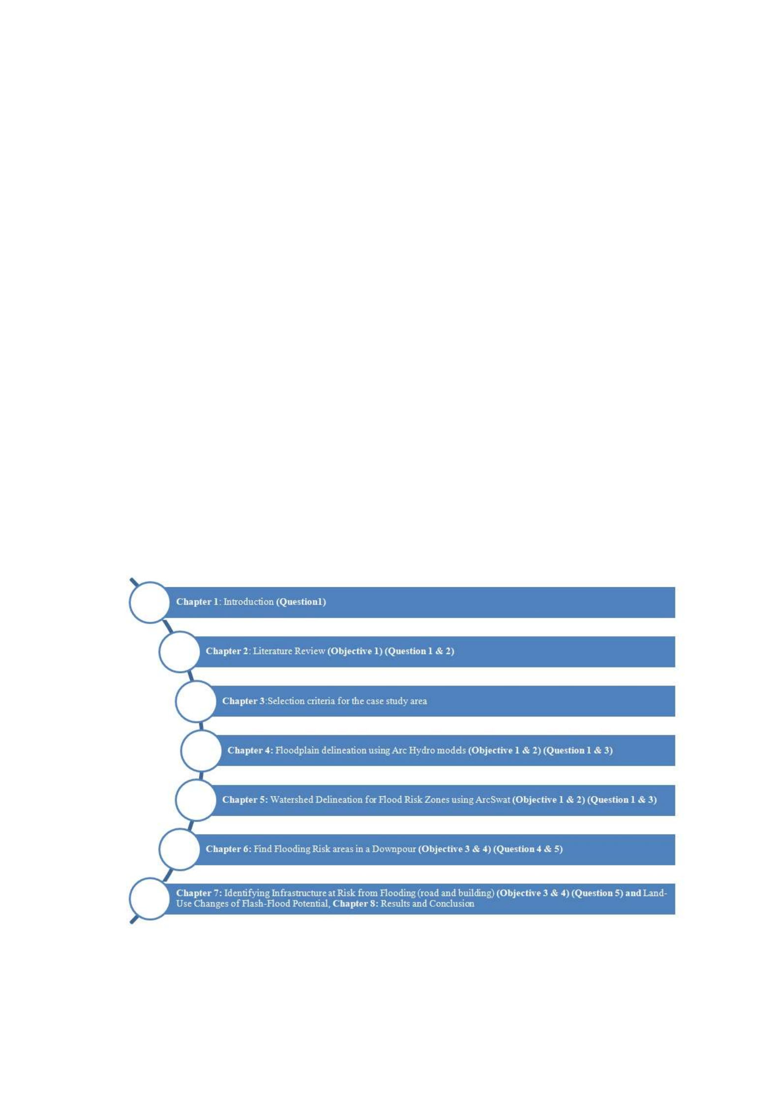
Data used at the first and the second stages of the research focuses on flooding and floodplain
management in the Australian settings. The utilisation of LiDAR enables users to perform a
spatial investigation and a reasonable hydrological visualisation. The examination of GIS
functionalities in hydrological and LiDAR applications conducted at the third and fourth stages
shows the effects along the Victorian creek. These stages investigate the importance of GIS
database for ‘on-request’ hydrological examination and flood modelling over the use of spatial
datasets. This investigation allows to reveal the gaps in GIS information and indicate the
required characteristics of hydrology models for flood modelling. As a result, the fourth stage
will address the central problem of the present research and its objectives.
The knowledge gained from this project could be used to inform future FM and provide spatial
information infrastructure (SII) policy reforms in Victoria. Additionally, the results of the
research might close the previously mentioned policy-to-practice gaps related to the integration
of spatial decision-support for FM in Victoria.
Structure and Outline of the Thesis
Figure 1.2, presented below, reflect the structure of the thesis that is comprised of eight
chapters.
Figure 1.2: Structure of the thesis in relation to the objectives and research questions.

As it has already been stated, the first stage of the research is comprised of research
formulation, literature review and development of the strategy. Chapter 1 includes the
introduction and the theoretical framework of the thesis. It also described the problem, aim,
and questions of the research. The literature review on flooding, flood management, GIS and
Hydrological modelling could be found in Chapter 2 that answers the first and the second
research questions.
The second stage includes the case studies and the pilot study area that are described in chapter
3 “Pilot study area: City of Whittlesea (CoW)”. This section explains the standards for choosing
the pilot study area (the CoW) and hydrological and associated qualities of this area.
The focus of the third step of the thesis is directed at GIS data structures and processes for
integrating GIS with hydrological modelling. Therefore, chapter 4 discusses a case study aimed
at floodplain delineation using ArcHydro models, the choice of methods and user data
information needs in the context of local flood-risk analysis. It depicts the strategies and result
of spatial information linking for extricating overland flow through the property and reduces
the risk of flash flooding area utilizing GIS-embedded hydrological model with machine
learning techniques. In this chapter, the author also discusses the limitations in existing local
flood relevant spatial databases and answers the first and the third research questions.
Chapter 5 includes a case study on the watershed delineation of flood risk zones through
ArcSwat. The numerical models, introduced in this chapter, can simulate hydrological
processes by ArcSWAT. This chapter answers the research questions one and three.
Stage four involves GIS design and development for flood support of climate change tools.
Chapter 6 that is a case study on finding areas at risk of flooding in a downpour, presents the
results of the fourth step. This chapter applies the DEM dataset in GIS-embedded hydrological
model with machine learning techniques and answers the fourth and the fifth research
questions.
The penultimate stage of the thesis paper reveals the outcomes, flood scenarios and
infrastructure risk tools. Chapter 6 is comprised of a case study which develops an approach
for identifying infrastructure at risk from flooding, LiDAR modelling of flood inundation under
future and describes the current and future threats to infrastructure. Since chapter 7 is dedicated
to the discussion of GIS, remote sensing, and machine learning, it highlights the correlation
between the land-use changes and flash-flood potential. Chapter 7 answers the sixth research
questions.

The objective of the final stage of the research is to present conclusions and recommendations.
Chapter 8 that is the synthesis of findings, contains the results of this stage, conclusions and
recommendations for future research for improving Victoria’s flood management. In addition,
the last chapter provides suggestions for future research. Chapter 8 addresses the problem and
primary research objectives as well as the ways for future research.
Scope and the Key Assumptions of the Research
Undoubtedly, “spatial industry” faces certain limitations in term of the implementation of
policies directed at the mitigation of climate change (Douglas et al. 2008). This is illustrated
by the consequences of flood management practices used in Victoria in 2016. Thus, the critical
assumption of the research is that the modern models of floods have the capability to make
predictions only about urban areas. Furthermore, DEM datasets regard urban landscapes as a
stable during the whole time of the disaster. The conclusions that were reached in the fourth,
fifth, sixth and seventh chapters of the paper depict that it would be more beneficial to use
different tools to estimate the impact that floods would cause for infrastructural objects. The
sections from fourth to seventh bring novelty to the scientific community since the bridge the
gap of the limited research on simulation of floods impact on infrastructure.
Most importantly, there is no other research that would build an investigation of
interdependencies between flash-flood potential and land-use changes upon the combination
of GIS and hydrology model with machine learning. At the same time, it must be admitted that
the area that was used for the analysis in the paper was not affected by a flood. Nevertheless,
despite this fact, the presented procedure is universal and, consequently, could be applied in
any other area without exceptions.
Summary
The first chapter formulates the scientific and practical values of the research, its aims,
objectives, structure and could be viewed as the framework and the foundation for the
subsequent chapters. The second chapter reviews the literature on such topics as GIS,
hydrology, and information models that are applied for the analysis. The following four
sections describe the case study and by formulating the results not only answer the research
question but also bring novelty to the issued field of research.
Methods

The adoption and diffusion of decision support technology, with application to flood risk
management in Victoria, signify the conceptual basis for this thesis. Digital spatial information
modelling and the integration of the data and information used in the decision-support system
illustrate the technical basis of the paper.
In this research, the relevant data and information were gathered and analysed by the
application of a case study approach. As it was noticed by Serrao-Neumann et al. (2013), the
contextual analyses allow the researcher to look at natural phenomena in their typical setting
and use the information acquired by various methods and sources. Multiple disciplines, from
research on information systems operation, apply learning based on cases (Rajabifard et al.
2002, Mohammadi 2008, McDougall 2006). According to the previously mentioned scholars,
a case study approach is immensely suitable for investigation of the information systems field
because this filed continually innovates and undergoes changes (Rajabifard et al. 2002,
Mohammadi 2008, McDougall 2006).
Yin (2003) believes that when the phenomenon under study is identical to its context, the case
study research method also could be used. For instance, the complex interactions between
advanced technologies and organisations illustrate these circumstances. Hence, case study
research methods signify that the researcher asks “how and why” questions, focuses on the
contemporary phenomenon within a real-life context, and has the little opportunity to control
the events. Therefore, the application of contextual analyses is the most appropriate when the
investigator broadly defines research topics and covers not simply disengaged factors but
contextual or complex multivariate conditions (Yin 2003). Furthermore, according to Yin
(2003), it is essential to use opinions of the technology to understand the actual uses of the
technology and potential difficulties being faced by adopters if a case study refers to such
innovation as digital spatial information and enabling knowledge. The author of the current
research was an employee in the City of Whittlesea (CoW), and this experience allowed him
to make observations at the augmented level and investigate the dynamics of surrounding
organisational behaviour of the stakeholders towards enabling technology and geospatial data
(Yin 2003).
Figure 1.1 reflects the research design of the project that unites a framework for information
systems case study research approaches as it was described by Kaplan and Duchon (1988),
Lee and Heaney (2003), Onsrud et al. (1992) and Yin (2003). The first stage of the research
design is comprised of the detailed project formulation, including reviewing of the relevant

theory and practice that provides the foundation for the further improvement of an appropriate
theoretical framework for data collection and evaluation. This is possible due to the utilisation
of data and information collected through mixed research methods used at the second stage.
The third stage uses data and information gathered at the preceding step of the research. These
materials were obtained in the result of the development of a suite of flood management (FM)
stakeholder needs-focussed geospatial tools for the implementation within the Victorian FM
program. FM program created for Victoria is universal and, therefore, could be adapted to
other national and world-wide FM programs.
The data and information that were obtained during the first two stages are used for further
investigation at the third stage of the research. The outputs of the first three steps form the
fourth stage that includes the conclusions and recommendations of this thesis.
Figure 1.1: Proposed research design.
The final conclusions and recommendations of the present research paper will be based on the
synthesis and analysis of the first, second, and thirds stages. The first two stages present
information on the of a GIS-embedded hydrological model with machine learning techniques,
to improve administrative practices informed by flood hazard modelling. This information
includes a review of literature dedicated to the floodplain management in the Victoria setting.

Apart from that, it also consists of the user needs of spatial analysis and the concept of
hydrological modelling using Light Detection and Ranging (LiDAR).
The discussion presented in the third and fourth stages highlights the following topics:
• GIS functionalities in hydrological modelling and LiDAR data implementation for the
Victorian Council’s flood model;
• The importance of the spatial database for “on-request” hydrological modelling;
• Flood modelling through an examination of GIS datasets to detect the gaps in spatial
information and the essential characteristics;
• GIS in Water Resources with machine learning and Flood Risk Management;
Data used at the first and the second stages of the research focuses on flooding and floodplain
management in the Australian settings. The utilisation of LiDAR enables users to perform a
spatial investigation and a reasonable hydrological visualisation. The examination of GIS
functionalities in hydrological and LiDAR applications conducted at the third and fourth stages
shows the effects along the Victorian creek. These stages investigate the importance of GIS
database for ‘on-request’ hydrological examination and flood modelling over the use of spatial
datasets. This investigation allows to reveal the gaps in GIS information and indicate the
required characteristics of hydrology models for flood modelling. As a result, the fourth stage
will address the central problem of the present research and its objectives.
The knowledge gained from this project could be used to inform future FM and provide spatial
information infrastructure (SII) policy reforms in Victoria. Additionally, the results of the
research might close the previously mentioned policy-to-practice gaps related to the integration
of spatial decision-support for FM in Victoria.
Structure and Outline of the Thesis
Figure 1.2, presented below, reflect the structure of the thesis that is comprised of eight
chapters.

Figure 1.2: Structure of the thesis in relation to the objectives and research questions.
As it has already been stated, the first stage of the research is comprised of research
formulation, literature review and development of the strategy. Chapter 1 includes the
introduction and the theoretical framework of the thesis. It also described the problem, aim,
and questions of the research. The literature review on flooding, flood management, GIS and
Hydrological modelling could be found in Chapter 2 that answers the first and the second
research questions.
The second stage includes the case studies and the pilot study area that are described in chapter
3 “Pilot study area: City of Whittlesea (CoW)”. This section explains the standards for choosing
the pilot study area (the CoW) and hydrological and associated qualities of this area.
The focus of the third step of the thesis is directed at GIS data structures and processes for
integrating GIS with hydrological modelling. Therefore, chapter 4 discusses a case study aimed
at floodplain delineation using ArcHydro models, the choice of methods and user data
information needs in the context of local flood-risk analysis. It depicts the strategies and result
of spatial information linking for extricating overland flow through the property and reduces
the risk of flash flooding area utilizing GIS-embedded hydrological model with machine
learning techniques. In this chapter, the author also discusses the limitations in existing local
flood relevant spatial databases and answers the first and the third research questions.

Chapter 5 includes a case study on the watershed delineation of flood risk zones through
ArcSwat. The numerical models, introduced in this chapter, can simulate hydrological
processes by ArcSWAT. This chapter answers the research questions one and three.
Stage four involves GIS design and development for flood support of climate change tools.
Chapter 6 that is a case study on finding areas at risk of flooding in a downpour, presents the
results of the fourth step. This chapter applies the DEM dataset in GIS-embedded hydrological
model with machine learning techniques and answers the fourth and the fifth research
questions.
The penultimate stage of the thesis paper reveals the outcomes, flood scenarios and
infrastructure risk tools. Chapter 6 is comprised of a case study which develops an approach
for identifying infrastructure at risk from flooding, LiDAR modelling of flood inundation under
future and describes the current and future threats to infrastructure. Since chapter 7 is dedicated
to the discussion of GIS, remote sensing, and machine learning, it highlights the correlation
between the land-use changes and flash-flood potential. Chapter 7 answers the sixth research
questions.
The objective of the final stage of the research is to present conclusions and recommendations.
Chapter 8 that is the synthesis of findings, contains the results of this stage, conclusions and
recommendations for future research for improving Victoria’s flood management. In addition,
the last chapter provides suggestions for future research. Chapter 8 addresses the problem and
primary research objectives as well as the ways for future research.
Scope and the Key Assumptions of the Research
Undoubtedly, “spatial industry” faces certain limitations in term of the implementation of
policies directed at the mitigation of climate change (Douglas et al. 2008). This is illustrated
by the consequences of flood management practices used in Victoria in 2016. Thus, the critical
assumption of the research is that the modern models of floods have the capability to make
predictions only about urban areas. Furthermore, DEM datasets regard urban landscapes as a
stable during the whole time of the disaster. The conclusions that were reached in the fourth,
fifth, sixth and seventh chapters of the paper depict that it would be more beneficial to use
different tools to estimate the impact that floods would cause for infrastructural objects. The
sections from fourth to seventh bring novelty to the scientific community since the bridge the
gap of the limited research on simulation of floods impact on infrastructure.

Most importantly, there is no other research that would build an investigation of
interdependencies between flash-flood potential and land-use changes upon the combination
of GIS and hydrology model with machine learning. At the same time, it must be admitted that
the area that was used for the analysis in the paper was not affected by a flood. Nevertheless,
despite this fact, the presented procedure is universal and, consequently, could be applied in
any other area without exceptions.
Summary
The first chapter formulates the scientific and practical values of the research, its aims,
objectives, structure and could be viewed as the framework and the foundation for the
subsequent chapters. The second chapter reviews the literature on such topics as GIS,
hydrology, and information models that are applied for the analysis. The following four
sections describe the case study and by formulating the results not only answer the research
question but also bring novelty to the issued field of research.
Methods
The adoption and diffusion of decision support technology, with application to flood risk
management in Victoria, signify the conceptual basis for this thesis. Digital spatial information
modelling and the integration of the data and information used in the decision-support system
illustrate the technical basis of the paper.
In this research, the relevant data and information were gathered and analysed by the
application of a case study approach. As it was noticed by Serrao-Neumann et al. (2013), the
contextual analyses allow the researcher to look at natural phenomena in their typical setting
and use the information acquired by various methods and sources. Multiple disciplines, from
research on information systems operation, apply learning based on cases (Rajabifard et al.
2002, Mohammadi 2008, McDougall 2006). According to the previously mentioned scholars,
a case study approach is immensely suitable for investigation of the information systems field
because this filed continually innovates and undergoes changes (Rajabifard et al. 2002,
Mohammadi 2008, McDougall 2006).
Yin (2003) believes that when the phenomenon under study is identical to its context, the case
study research method also could be used. For instance, the complex interactions between
advanced technologies and organisations illustrate these circumstances. Hence, case study
research methods signify that the researcher asks “how and why” questions, focuses on the

contemporary phenomenon within a real-life context, and has the little opportunity to control
the events. Therefore, the application of contextual analyses is the most appropriate when the
investigator broadly defines research topics and covers not simply disengaged factors but
contextual or complex multivariate conditions (Yin 2003). Furthermore, according to Yin
(2003), it is essential to use opinions of the technology to understand the actual uses of the
technology and potential difficulties being faced by adopters if a case study refers to such
innovation as digital spatial information and enabling knowledge. The author of the current
research was an employee in the City of Whittlesea (CoW), and this experience allowed him
to make observations at the augmented level and investigate the dynamics of surrounding
organisational behaviour of the stakeholders towards enabling technology and geospatial data
(Yin 2003).
Figure 1.1 reflects the research design of the project that unites a framework for information
systems case study research approaches as it was described by Kaplan and Duchon (1988),
Lee and Heaney (2003), Onsrud et al. (1992) and Yin (2003). The first stage of the research
design is comprised of the detailed project formulation, including reviewing of the relevant
theory and practice that provides the foundation for the further improvement of an appropriate
theoretical framework for data collection and evaluation. This is possible due to the utilisation
of data and information collected through mixed research methods used at the second stage.
The third stage uses data and information gathered at the preceding step of the research. These
materials were obtained in the result of the development of a suite of flood management (FM)
stakeholder needs-focussed geospatial tools for the implementation within the Victorian FM
program. FM program created for Victoria is universal and, therefore, could be adapted to
other national and world-wide FM programs.
The data and information that were obtained during the first two stages are used for further
investigation at the third stage of the research. The outputs of the first three steps form the
fourth stage that includes the conclusions and recommendations of this thesis.

Figure 1.1: Proposed research design.
The final conclusions and recommendations of the present research paper will be based on the
synthesis and analysis of the first, second, and thirds stages. The first two stages present
information on the of a GIS-embedded hydrological model with machine learning techniques,
to improve administrative practices informed by flood hazard modelling. This information
includes a review of literature dedicated to the floodplain management in the Victoria setting.
Apart from that, it also consists of the user needs of spatial analysis and the concept of
hydrological modelling using Light Detection and Ranging (LiDAR).
The discussion presented in the third and fourth stages highlights the following topics:
• GIS functionalities in hydrological modelling and LiDAR data implementation for the
Victorian Council’s flood model;
• The importance of the spatial database for “on-request” hydrological modelling;
• Flood modelling through an examination of GIS datasets to detect the gaps in spatial
information and the essential characteristics;
• GIS in Water Resources with machine learning and Flood Risk Management;

Data used at the first and the second stages of the research focuses on flooding and floodplain
management in the Australian settings. The utilisation of LiDAR enables users to perform a
spatial investigation and a reasonable hydrological visualisation. The examination of GIS
functionalities in hydrological and LiDAR applications conducted at the third and fourth stages
shows the effects along the Victorian creek. These stages investigate the importance of GIS
database for ‘on-request’ hydrological examination and flood modelling over the use of spatial
datasets. This investigation allows to reveal the gaps in GIS information and indicate the
required characteristics of hydrology models for flood modelling. As a result, the fourth stage
will address the central problem of the present research and its objectives.
The knowledge gained from this project could be used to inform future FM and provide spatial
information infrastructure (SII) policy reforms in Victoria. Additionally, the results of the
research might close the previously mentioned policy-to-practice gaps related to the integration
of spatial decision-support for FM in Victoria.
Structure and Outline of the Thesis
Figure 1.2, presented below, reflect the structure of the thesis that is comprised of eight
chapters.
Figure 1.2: Structure of the thesis in relation to the objectives and research questions.

As it has already been stated, the first stage of the research is comprised of research
formulation, literature review and development of the strategy. Chapter 1 includes the
introduction and the theoretical framework of the thesis. It also described the problem, aim,
and questions of the research. The literature review on flooding, flood management, GIS and
Hydrological modelling could be found in Chapter 2 that answers the first and the second
research questions.
The second stage includes the case studies and the pilot study area that are described in chapter
3 “Pilot study area: City of Whittlesea (CoW)”. This section explains the standards for choosing
the pilot study area (the CoW) and hydrological and associated qualities of this area.
The focus of the third step of the thesis is directed at GIS data structures and processes for
integrating GIS with hydrological modelling. Therefore, chapter 4 discusses a case study aimed
at floodplain delineation using ArcHydro models, the choice of methods and user data
information needs in the context of local flood-risk analysis. It depicts the strategies and result
of spatial information linking for extricating overland flow through the property and reduces
the risk of flash flooding area utilizing GIS-embedded hydrological model with machine
learning techniques. In this chapter, the author also discusses the limitations in existing local
flood relevant spatial databases and answers the first and the third research questions.
Chapter 5 includes a case study on the watershed delineation of flood risk zones through
ArcSwat. The numerical models, introduced in this chapter, can simulate hydrological
processes by ArcSWAT. This chapter answers the research questions one and three.
Stage four involves GIS design and development for flood support of climate change tools.
Chapter 6 that is a case study on finding areas at risk of flooding in a downpour, presents the
results of the fourth step. This chapter applies the DEM dataset in GIS-embedded hydrological
model with machine learning techniques and answers the fourth and the fifth research
questions.
The penultimate stage of the thesis paper reveals the outcomes, flood scenarios and
infrastructure risk tools. Chapter 6 is comprised of a case study which develops an approach
for identifying infrastructure at risk from flooding, LiDAR modelling of flood inundation under
future and describes the current and future threats to infrastructure. Since chapter 7 is dedicated
to the discussion of GIS, remote sensing, and machine learning, it highlights the correlation
between the land-use changes and flash-flood potential. Chapter 7 answers the sixth research
questions.

The objective of the final stage of the research is to present conclusions and recommendations.
Chapter 8 that is the synthesis of findings, contains the results of this stage, conclusions and
recommendations for future research for improving Victoria’s flood management. In addition,
the last chapter provides suggestions for future research. Chapter 8 addresses the problem and
primary research objectives as well as the ways for future research.
Scope and the Key Assumptions of the Research
Undoubtedly, “spatial industry” faces certain limitations in term of the implementation of
policies directed at the mitigation of climate change (Douglas et al. 2008). This is illustrated
by the consequences of flood management practices used in Victoria in 2016. Thus, the critical
assumption of the research is that the modern models of floods have the capability to make
predictions only about urban areas. Furthermore, DEM datasets regard urban landscapes as a
stable during the whole time of the disaster. The conclusions that were reached in the fourth,
fifth, sixth and seventh chapters of the paper depict that it would be more beneficial to use
different tools to estimate the impact that floods would cause for infrastructural objects. The
sections from fourth to seventh bring novelty to the scientific community since the bridge the
gap of the limited research on simulation of floods impact on infrastructure.
Most importantly, there is no other research that would build an investigation of
interdependencies between flash-flood potential and land-use changes upon the combination
of GIS and hydrology model with machine learning. At the same time, it must be admitted that
the area that was used for the analysis in the paper was not affected by a flood. Nevertheless,
despite this fact, the presented procedure is universal and, consequently, could be applied in
any other area without exceptions.
Summary
The first chapter formulates the scientific and practical values of the research, its aims,
objectives, structure and could be viewed as the framework and the foundation for the
subsequent chapters. The second chapter reviews the literature on such topics as GIS,
hydrology, and information models that are applied for the analysis. The following four
sections describe the case study and by formulating the results not only answer the research
question but also bring novelty to the issued field of research.
Methods

The adoption and diffusion of decision support technology, with application to flood risk
management in Victoria, signify the conceptual basis for this thesis. Digital spatial information
modelling and the integration of the data and information used in the decision-support system
illustrate the technical basis of the paper.
In this research, the relevant data and information were gathered and analysed by the
application of a case study approach. As it was noticed by Serrao-Neumann et al. (2013), the
contextual analyses allow the researcher to look at natural phenomena in their typical setting
and use the information acquired by various methods and sources. Multiple disciplines, from
research on information systems operation, apply learning based on cases (Rajabifard et al.
2002, Mohammadi 2008, McDougall 2006). According to the previously mentioned scholars,
a case study approach is immensely suitable for investigation of the information systems field
because this filed continually innovates and undergoes changes (Rajabifard et al. 2002,
Mohammadi 2008, McDougall 2006).
Yin (2003) believes that when the phenomenon under study is identical to its context, the case
study research method also could be used. For instance, the complex interactions between
advanced technologies and organisations illustrate these circumstances. Hence, case study
research methods signify that the researcher asks “how and why” questions, focuses on the
contemporary phenomenon within a real-life context, and has the little opportunity to control
the events. Therefore, the application of contextual analyses is the most appropriate when the
investigator broadly defines research topics and covers not simply disengaged factors but
contextual or complex multivariate conditions (Yin 2003). Furthermore, according to Yin
(2003), it is essential to use opinions of the technology to understand the actual uses of the
technology and potential difficulties being faced by adopters if a case study refers to such
innovation as digital spatial information and enabling knowledge. The author of the current
research was an employee in the City of Whittlesea (CoW), and this experience allowed him
to make observations at the augmented level and investigate the dynamics of surrounding
organisational behaviour of the stakeholders towards enabling technology and geospatial data
(Yin 2003).
Figure 1.1 reflects the research design of the project that unites a framework for information
systems case study research approaches as it was described by Kaplan and Duchon (1988),
Lee and Heaney (2003), Onsrud et al. (1992) and Yin (2003). The first stage of the research
design is comprised of the detailed project formulation, including reviewing of the relevant

theory and practice that provides the foundation for the further improvement of an appropriate
theoretical framework for data collection and evaluation. This is possible due to the utilisation
of data and information collected through mixed research methods used at the second stage.
The third stage uses data and information gathered at the preceding step of the research. These
materials were obtained in the result of the development of a suite of flood management (FM)
stakeholder needs-focussed geospatial tools for the implementation within the Victorian FM
program. FM program created for Victoria is universal and, therefore, could be adapted to
other national and world-wide FM programs.
The data and information that were obtained during the first two stages are used for further
investigation at the third stage of the research. The outputs of the first three steps form the
fourth stage that includes the conclusions and recommendations of this thesis.
Figure 1.1: Proposed research design.
The final conclusions and recommendations of the present research paper will be based on the
synthesis and analysis of the first, second, and thirds stages. The first two stages present
information on the of a GIS-embedded hydrological model with machine learning techniques,
to improve administrative practices informed by flood hazard modelling. This information
includes a review of literature dedicated to the floodplain management in the Victoria setting.

Apart from that, it also consists of the user needs of spatial analysis and the concept of
hydrological modelling using Light Detection and Ranging (LiDAR).
The discussion presented in the third and fourth stages highlights the following topics:
• GIS functionalities in hydrological modelling and LiDAR data implementation for the
Victorian Council’s flood model;
• The importance of the spatial database for “on-request” hydrological modelling;
• Flood modelling through an examination of GIS datasets to detect the gaps in spatial
information and the essential characteristics;
• GIS in Water Resources with machine learning and Flood Risk Management;
Data used at the first and the second stages of the research focuses on flooding and floodplain
management in the Australian settings. The utilisation of LiDAR enables users to perform a
spatial investigation and a reasonable hydrological visualisation. The examination of GIS
functionalities in hydrological and LiDAR applications conducted at the third and fourth stages
shows the effects along the Victorian creek. These stages investigate the importance of GIS
database for ‘on-request’ hydrological examination and flood modelling over the use of spatial
datasets. This investigation allows to reveal the gaps in GIS information and indicate the
required characteristics of hydrology models for flood modelling. As a result, the fourth stage
will address the central problem of the present research and its objectives.
The knowledge gained from this project could be used to inform future FM and provide spatial
information infrastructure (SII) policy reforms in Victoria. Additionally, the results of the
research might close the previously mentioned policy-to-practice gaps related to the integration
of spatial decision-support for FM in Victoria.
Structure and Outline of the Thesis
Figure 1.2, presented below, reflect the structure of the thesis that is comprised of eight
chapters.

Figure 1.2: Structure of the thesis in relation to the objectives and research questions.
As it has already been stated, the first stage of the research is comprised of research
formulation, literature review and development of the strategy. Chapter 1 includes the
introduction and the theoretical framework of the thesis. It also described the problem, aim,
and questions of the research. The literature review on flooding, flood management, GIS and
Hydrological modelling could be found in Chapter 2 that answers the first and the second
research questions.
The second stage includes the case studies and the pilot study area that are described in chapter
3 “Pilot study area: City of Whittlesea (CoW)”. This section explains the standards for choosing
the pilot study area (the CoW) and hydrological and associated qualities of this area.
The focus of the third step of the thesis is directed at GIS data structures and processes for
integrating GIS with hydrological modelling. Therefore, chapter 4 discusses a case study aimed
at floodplain delineation using ArcHydro models, the choice of methods and user data
information needs in the context of local flood-risk analysis. It depicts the strategies and result
of spatial information linking for extricating overland flow through the property and reduces
the risk of flash flooding area utilizing GIS-embedded hydrological model with machine
learning techniques. In this chapter, the author also discusses the limitations in existing local
flood relevant spatial databases and answers the first and the third research questions.

Chapter 5 includes a case study on the watershed delineation of flood risk zones through
ArcSwat. The numerical models, introduced in this chapter, can simulate hydrological
processes by ArcSWAT. This chapter answers the research questions one and three.
Stage four involves GIS design and development for flood support of climate change tools.
Chapter 6 that is a case study on finding areas at risk of flooding in a downpour, presents the
results of the fourth step. This chapter applies the DEM dataset in GIS-embedded hydrological
model with machine learning techniques and answers the fourth and the fifth research
questions.
The penultimate stage of the thesis paper reveals the outcomes, flood scenarios and
infrastructure risk tools. Chapter 6 is comprised of a case study which develops an approach
for identifying infrastructure at risk from flooding, LiDAR modelling of flood inundation under
future and describes the current and future threats to infrastructure. Since chapter 7 is dedicated
to the discussion of GIS, remote sensing, and machine learning, it highlights the correlation
between the land-use changes and flash-flood potential. Chapter 7 answers the sixth research
questions.
The objective of the final stage of the research is to present conclusions and recommendations.
Chapter 8 that is the synthesis of findings, contains the results of this stage, conclusions and
recommendations for future research for improving Victoria’s flood management. In addition,
the last chapter provides suggestions for future research. Chapter 8 addresses the problem and
primary research objectives as well as the ways for future research.
Scope and the Key Assumptions of the Research
Undoubtedly, “spatial industry” faces certain limitations in term of the implementation of
policies directed at the mitigation of climate change (Douglas et al. 2008). This is illustrated
by the consequences of flood management practices used in Victoria in 2016. Thus, the critical
assumption of the research is that the modern models of floods have the capability to make
predictions only about urban areas. Furthermore, DEM datasets regard urban landscapes as a
stable during the whole time of the disaster. The conclusions that were reached in the fourth,
fifth, sixth and seventh chapters of the paper depict that it would be more beneficial to use
different tools to estimate the impact that floods would cause for infrastructural objects. The
sections from fourth to seventh bring novelty to the scientific community since the bridge the
gap of the limited research on simulation of floods impact on infrastructure.

Most importantly, there is no other research that would build an investigation of
interdependencies between flash-flood potential and land-use changes upon the combination
of GIS and hydrology model with machine learning. At the same time, it must be admitted that
the area that was used for the analysis in the paper was not affected by a flood. Nevertheless,
despite this fact, the presented procedure is universal and, consequently, could be applied in
any other area without exceptions.
Summary
The first chapter formulates the scientific and practical values of the research, its aims,
objectives, structure and could be viewed as the framework and the foundation for the
subsequent chapters. The second chapter reviews the literature on such topics as GIS,
hydrology, and information models that are applied for the analysis. The following four
sections describe the case study and by formulating the results not only answer the research
question but also bring novelty to the issued field of research.
Methods
The adoption and diffusion of decision support technology, with application to flood risk
management in Victoria, signify the conceptual basis for this thesis. Digital spatial information
modelling and the integration of the data and information used in the decision-support system
illustrate the technical basis of the paper.
In this research, the relevant data and information were gathered and analysed by the
application of a case study approach. As it was noticed by Serrao-Neumann et al. (2013), the
contextual analyses allow the researcher to look at natural phenomena in their typical setting
and use the information acquired by various methods and sources. Multiple disciplines, from
research on information systems operation, apply learning based on cases (Rajabifard et al.
2002, Mohammadi 2008, McDougall 2006). According to the previously mentioned scholars,
a case study approach is immensely suitable for investigation of the information systems field
because this filed continually innovates and undergoes changes (Rajabifard et al. 2002,
Mohammadi 2008, McDougall 2006).
Yin (2003) believes that when the phenomenon under study is identical to its context, the case
study research method also could be used. For instance, the complex interactions between
advanced technologies and organisations illustrate these circumstances. Hence, case study
research methods signify that the researcher asks “how and why” questions, focuses on the

contemporary phenomenon within a real-life context, and has the little opportunity to control
the events. Therefore, the application of contextual analyses is the most appropriate when the
investigator broadly defines research topics and covers not simply disengaged factors but
contextual or complex multivariate conditions (Yin 2003). Furthermore, according to Yin
(2003), it is essential to use opinions of the technology to understand the actual uses of the
technology and potential difficulties being faced by adopters if a case study refers to such
innovation as digital spatial information and enabling knowledge. The author of the current
research was an employee in the City of Whittlesea (CoW), and this experience allowed him
to make observations at the augmented level and investigate the dynamics of surrounding
organisational behaviour of the stakeholders towards enabling technology and geospatial data
(Yin 2003).
Figure 1.1 reflects the research design of the project that unites a framework for information
systems case study research approaches as it was described by Kaplan and Duchon (1988),
Lee and Heaney (2003), Onsrud et al. (1992) and Yin (2003). The first stage of the research
design is comprised of the detailed project formulation, including reviewing of the relevant
theory and practice that provides the foundation for the further improvement of an appropriate
theoretical framework for data collection and evaluation. This is possible due to the utilisation
of data and information collected through mixed research methods used at the second stage.
The third stage uses data and information gathered at the preceding step of the research. These
materials were obtained in the result of the development of a suite of flood management (FM)
stakeholder needs-focussed geospatial tools for the implementation within the Victorian FM
program. FM program created for Victoria is universal and, therefore, could be adapted to
other national and world-wide FM programs.
The data and information that were obtained during the first two stages are used for further
investigation at the third stage of the research. The outputs of the first three steps form the
fourth stage that includes the conclusions and recommendations of this thesis.

Figure 1.1: Proposed research design.
The final conclusions and recommendations of the present research paper will be based on the
synthesis and analysis of the first, second, and thirds stages. The first two stages present
information on the of a GIS-embedded hydrological model with machine learning techniques,
to improve administrative practices informed by flood hazard modelling. This information
includes a review of literature dedicated to the floodplain management in the Victoria setting.
Apart from that, it also consists of the user needs of spatial analysis and the concept of
hydrological modelling using Light Detection and Ranging (LiDAR).
The discussion presented in the third and fourth stages highlights the following topics:
• GIS functionalities in hydrological modelling and LiDAR data implementation for the
Victorian Council’s flood model;
• The importance of the spatial database for “on-request” hydrological modelling;
• Flood modelling through an examination of GIS datasets to detect the gaps in spatial
information and the essential characteristics;
• GIS in Water Resources with machine learning and Flood Risk Management;

Data used at the first and the second stages of the research focuses on flooding and floodplain
management in the Australian settings. The utilisation of LiDAR enables users to perform a
spatial investigation and a reasonable hydrological visualisation. The examination of GIS
functionalities in hydrological and LiDAR applications conducted at the third and fourth stages
shows the effects along the Victorian creek. These stages investigate the importance of GIS
database for ‘on-request’ hydrological examination and flood modelling over the use of spatial
datasets. This investigation allows to reveal the gaps in GIS information and indicate the
required characteristics of hydrology models for flood modelling. As a result, the fourth stage
will address the central problem of the present research and its objectives.
The knowledge gained from this project could be used to inform future FM and provide spatial
information infrastructure (SII) policy reforms in Victoria. Additionally, the results of the
research might close the previously mentioned policy-to-practice gaps related to the integration
of spatial decision-support for FM in Victoria.
Structure and Outline of the Thesis
Figure 1.2, presented below, reflect the structure of the thesis that is comprised of eight
chapters.
Figure 1.2: Structure of the thesis in relation to the objectives and research questions.

As it has already been stated, the first stage of the research is comprised of research
formulation, literature review and development of the strategy. Chapter 1 includes the
introduction and the theoretical framework of the thesis. It also described the problem, aim,
and questions of the research. The literature review on flooding, flood management, GIS and
Hydrological modelling could be found in Chapter 2 that answers the first and the second
research questions.
The second stage includes the case studies and the pilot study area that are described in chapter
3 “Pilot study area: City of Whittlesea (CoW)”. This section explains the standards for choosing
the pilot study area (the CoW) and hydrological and associated qualities of this area.
The focus of the third step of the thesis is directed at GIS data structures and processes for
integrating GIS with hydrological modelling. Therefore, chapter 4 discusses a case study aimed
at floodplain delineation using ArcHydro models, the choice of methods and user data
information needs in the context of local flood-risk analysis. It depicts the strategies and result
of spatial information linking for extricating overland flow through the property and reduces
the risk of flash flooding area utilizing GIS-embedded hydrological model with machine
learning techniques. In this chapter, the author also discusses the limitations in existing local
flood relevant spatial databases and answers the first and the third research questions.
Chapter 5 includes a case study on the watershed delineation of flood risk zones through
ArcSwat. The numerical models, introduced in this chapter, can simulate hydrological
processes by ArcSWAT. This chapter answers the research questions one and three.
Stage four involves GIS design and development for flood support of climate change tools.
Chapter 6 that is a case study on finding areas at risk of flooding in a downpour, presents the
results of the fourth step. This chapter applies the DEM dataset in GIS-embedded hydrological
model with machine learning techniques and answers the fourth and the fifth research
questions.
The penultimate stage of the thesis paper reveals the outcomes, flood scenarios and
infrastructure risk tools. Chapter 6 is comprised of a case study which develops an approach
for identifying infrastructure at risk from flooding, LiDAR modelling of flood inundation under
future and describes the current and future threats to infrastructure. Since chapter 7 is dedicated
to the discussion of GIS, remote sensing, and machine learning, it highlights the correlation
between the land-use changes and flash-flood potential. Chapter 7 answers the sixth research
questions.

The objective of the final stage of the research is to present conclusions and recommendations.
Chapter 8 that is the synthesis of findings, contains the results of this stage, conclusions and
recommendations for future research for improving Victoria’s flood management. In addition,
the last chapter provides suggestions for future research. Chapter 8 addresses the problem and
primary research objectives as well as the ways for future research.
Scope and the Key Assumptions of the Research
Undoubtedly, “spatial industry” faces certain limitations in term of the implementation of
policies directed at the mitigation of climate change (Douglas et al. 2008). This is illustrated
by the consequences of flood management practices used in Victoria in 2016. Thus, the critical
assumption of the research is that the modern models of floods have the capability to make
predictions only about urban areas. Furthermore, DEM datasets regard urban landscapes as a
stable during the whole time of the disaster. The conclusions that were reached in the fourth,
fifth, sixth and seventh chapters of the paper depict that it would be more beneficial to use
different tools to estimate the impact that floods would cause for infrastructural objects. The
sections from fourth to seventh bring novelty to the scientific community since the bridge the
gap of the limited research on simulation of floods impact on infrastructure.
Most importantly, there is no other research that would build an investigation of
interdependencies between flash-flood potential and land-use changes upon the combination
of GIS and hydrology model with machine learning. At the same time, it must be admitted that
the area that was used for the analysis in the paper was not affected by a flood. Nevertheless,
despite this fact, the presented procedure is universal and, consequently, could be applied in
any other area without exceptions.
Summary
The first chapter formulates the scientific and practical values of the research, its aims,
objectives, structure and could be viewed as the framework and the foundation for the
subsequent chapters. The second chapter reviews the literature on such topics as GIS,
hydrology, and information models that are applied for the analysis. The following four
sections describe the case study and by formulating the results not only answer the research
question but also bring novelty to the issued field of research.
Methods

The adoption and diffusion of decision support technology, with application to flood risk
management in Victoria, signify the conceptual basis for this thesis. Digital spatial information
modelling and the integration of the data and information used in the decision-support system
illustrate the technical basis of the paper.
In this research, the relevant data and information were gathered and analysed by the
application of a case study approach. As it was noticed by Serrao-Neumann et al. (2013), the
contextual analyses allow the researcher to look at natural phenomena in their typical setting
and use the information acquired by various methods and sources. Multiple disciplines, from
research on information systems operation, apply learning based on cases (Rajabifard et al.
2002, Mohammadi 2008, McDougall 2006). According to the previously mentioned scholars,
a case study approach is immensely suitable for investigation of the information systems field
because this filed continually innovates and undergoes changes (Rajabifard et al. 2002,
Mohammadi 2008, McDougall 2006).
Yin (2003) believes that when the phenomenon under study is identical to its context, the case
study research method also could be used. For instance, the complex interactions between
advanced technologies and organisations illustrate these circumstances. Hence, case study
research methods signify that the researcher asks “how and why” questions, focuses on the
contemporary phenomenon within a real-life context, and has the little opportunity to control
the events. Therefore, the application of contextual analyses is the most appropriate when the
investigator broadly defines research topics and covers not simply disengaged factors but
contextual or complex multivariate conditions (Yin 2003). Furthermore, according to Yin
(2003), it is essential to use opinions of the technology to understand the actual uses of the
technology and potential difficulties being faced by adopters if a case study refers to such
innovation as digital spatial information and enabling knowledge. The author of the current
research was an employee in the City of Whittlesea (CoW), and this experience allowed him
to make observations at the augmented level and investigate the dynamics of surrounding
organisational behaviour of the stakeholders towards enabling technology and geospatial data
(Yin 2003).
Figure 1.1 reflects the research design of the project that unites a framework for information
systems case study research approaches as it was described by Kaplan and Duchon (1988),
Lee and Heaney (2003), Onsrud et al. (1992) and Yin (2003). The first stage of the research
design is comprised of the detailed project formulation, including reviewing of the relevant

theory and practice that provides the foundation for the further improvement of an appropriate
theoretical framework for data collection and evaluation. This is possible due to the utilisation
of data and information collected through mixed research methods used at the second stage.
The third stage uses data and information gathered at the preceding step of the research. These
materials were obtained in the result of the development of a suite of flood management (FM)
stakeholder needs-focussed geospatial tools for the implementation within the Victorian FM
program. FM program created for Victoria is universal and, therefore, could be adapted to
other national and world-wide FM programs.
The data and information that were obtained during the first two stages are used for further
investigation at the third stage of the research. The outputs of the first three steps form the
fourth stage that includes the conclusions and recommendations of this thesis.
Figure 1.1: Proposed research design.
The final conclusions and recommendations of the present research paper will be based on the
synthesis and analysis of the first, second, and thirds stages. The first two stages present
information on the of a GIS-embedded hydrological model with machine learning techniques,
to improve administrative practices informed by flood hazard modelling. This information
includes a review of literature dedicated to the floodplain management in the Victoria setting.

Apart from that, it also consists of the user needs of spatial analysis and the concept of
hydrological modelling using Light Detection and Ranging (LiDAR).
The discussion presented in the third and fourth stages highlights the following topics:
• GIS functionalities in hydrological modelling and LiDAR data implementation for the
Victorian Council’s flood model;
• The importance of the spatial database for “on-request” hydrological modelling;
• Flood modelling through an examination of GIS datasets to detect the gaps in spatial
information and the essential characteristics;
• GIS in Water Resources with machine learning and Flood Risk Management;
Data used at the first and the second stages of the research focuses on flooding and floodplain
management in the Australian settings. The utilisation of LiDAR enables users to perform a
spatial investigation and a reasonable hydrological visualisation. The examination of GIS
functionalities in hydrological and LiDAR applications conducted at the third and fourth stages
shows the effects along the Victorian creek. These stages investigate the importance of GIS
database for ‘on-request’ hydrological examination and flood modelling over the use of spatial
datasets. This investigation allows to reveal the gaps in GIS information and indicate the
required characteristics of hydrology models for flood modelling. As a result, the fourth stage
will address the central problem of the present research and its objectives.
The knowledge gained from this project could be used to inform future FM and provide spatial
information infrastructure (SII) policy reforms in Victoria. Additionally, the results of the
research might close the previously mentioned policy-to-practice gaps related to the integration
of spatial decision-support for FM in Victoria.
Structure and Outline of the Thesis
Figure 1.2, presented below, reflect the structure of the thesis that is comprised of eight
chapters.

Figure 1.2: Structure of the thesis in relation to the objectives and research questions.
As it has already been stated, the first stage of the research is comprised of research
formulation, literature review and development of the strategy. Chapter 1 includes the
introduction and the theoretical framework of the thesis. It also described the problem, aim,
and questions of the research. The literature review on flooding, flood management, GIS and
Hydrological modelling could be found in Chapter 2 that answers the first and the second
research questions.
The second stage includes the case studies and the pilot study area that are described in chapter
3 “Pilot study area: City of Whittlesea (CoW)”. This section explains the standards for choosing
the pilot study area (the CoW) and hydrological and associated qualities of this area.
The focus of the third step of the thesis is directed at GIS data structures and processes for
integrating GIS with hydrological modelling. Therefore, chapter 4 discusses a case study aimed
at floodplain delineation using ArcHydro models, the choice of methods and user data
information needs in the context of local flood-risk analysis. It depicts the strategies and result
of spatial information linking for extricating overland flow through the property and reduces
the risk of flash flooding area utilizing GIS-embedded hydrological model with machine
learning techniques. In this chapter, the author also discusses the limitations in existing local
flood relevant spatial databases and answers the first and the third research questions.

Chapter 5 includes a case study on the watershed delineation of flood risk zones through
ArcSwat. The numerical models, introduced in this chapter, can simulate hydrological
processes by ArcSWAT. This chapter answers the research questions one and three.
Stage four involves GIS design and development for flood support of climate change tools.
Chapter 6 that is a case study on finding areas at risk of flooding in a downpour, presents the
results of the fourth step. This chapter applies the DEM dataset in GIS-embedded hydrological
model with machine learning techniques and answers the fourth and the fifth research
questions.
The penultimate stage of the thesis paper reveals the outcomes, flood scenarios and
infrastructure risk tools. Chapter 6 is comprised of a case study which develops an approach
for identifying infrastructure at risk from flooding, LiDAR modelling of flood inundation under
future and describes the current and future threats to infrastructure. Since chapter 7 is dedicated
to the discussion of GIS, remote sensing, and machine learning, it highlights the correlation
between the land-use changes and flash-flood potential. Chapter 7 answers the sixth research
questions.
The objective of the final stage of the research is to present conclusions and recommendations.
Chapter 8 that is the synthesis of findings, contains the results of this stage, conclusions and
recommendations for future research for improving Victoria’s flood management. In addition,
the last chapter provides suggestions for future research. Chapter 8 addresses the problem and
primary research objectives as well as the ways for future research.
Scope and the Key Assumptions of the Research
Undoubtedly, “spatial industry” faces certain limitations in term of the implementation of
policies directed at the mitigation of climate change (Douglas et al. 2008). This is illustrated
by the consequences of flood management practices used in Victoria in 2016. Thus, the critical
assumption of the research is that the modern models of floods have the capability to make
predictions only about urban areas. Furthermore, DEM datasets regard urban landscapes as a
stable during the whole time of the disaster. The conclusions that were reached in the fourth,
fifth, sixth and seventh chapters of the paper depict that it would be more beneficial to use
different tools to estimate the impact that floods would cause for infrastructural objects. The
sections from fourth to seventh bring novelty to the scientific community since the bridge the
gap of the limited research on simulation of floods impact on infrastructure.

Most importantly, there is no other research that would build an investigation of
interdependencies between flash-flood potential and land-use changes upon the combination
of GIS and hydrology model with machine learning. At the same time, it must be admitted that
the area that was used for the analysis in the paper was not affected by a flood. Nevertheless,
despite this fact, the presented procedure is universal and, consequently, could be applied in
any other area without exceptions.
Summary
The first chapter formulates the scientific and practical values of the research, its aims,
objectives, structure and could be viewed as the framework and the foundation for the
subsequent chapters. The second chapter reviews the literature on such topics as GIS,
hydrology, and information models that are applied for the analysis. The following four
sections describe the case study and by formulating the results not only answer the research
question but also bring novelty to the issued field of research.
Methods
The adoption and diffusion of decision support technology, with application to flood risk
management in Victoria, signify the conceptual basis for this thesis. Digital spatial information
modelling and the integration of the data and information used in the decision-support system
illustrate the technical basis of the paper.
In this research, the relevant data and information were gathered and analysed by the
application of a case study approach. As it was noticed by Serrao-Neumann et al. (2013), the
contextual analyses allow the researcher to look at natural phenomena in their typical setting
and use the information acquired by various methods and sources. Multiple disciplines, from
research on information systems operation, apply learning based on cases (Rajabifard et al.
2002, Mohammadi 2008, McDougall 2006). According to the previously mentioned scholars,
a case study approach is immensely suitable for investigation of the information systems field
because this filed continually innovates and undergoes changes (Rajabifard et al. 2002,
Mohammadi 2008, McDougall 2006).
Yin (2003) believes that when the phenomenon under study is identical to its context, the case
study research method also could be used. For instance, the complex interactions between
advanced technologies and organisations illustrate these circumstances. Hence, case study
research methods signify that the researcher asks “how and why” questions, focuses on the

contemporary phenomenon within a real-life context, and has the little opportunity to control
the events. Therefore, the application of contextual analyses is the most appropriate when the
investigator broadly defines research topics and covers not simply disengaged factors but
contextual or complex multivariate conditions (Yin 2003). Furthermore, according to Yin
(2003), it is essential to use opinions of the technology to understand the actual uses of the
technology and potential difficulties being faced by adopters if a case study refers to such
innovation as digital spatial information and enabling knowledge. The author of the current
research was an employee in the City of Whittlesea (CoW), and this experience allowed him
to make observations at the augmented level and investigate the dynamics of surrounding
organisational behaviour of the stakeholders towards enabling technology and geospatial data
(Yin 2003).
Figure 1.1 reflects the research design of the project that unites a framework for information
systems case study research approaches as it was described by Kaplan and Duchon (1988),
Lee and Heaney (2003), Onsrud et al. (1992) and Yin (2003). The first stage of the research
design is comprised of the detailed project formulation, including reviewing of the relevant
theory and practice that provides the foundation for the further improvement of an appropriate
theoretical framework for data collection and evaluation. This is possible due to the utilisation
of data and information collected through mixed research methods used at the second stage.
The third stage uses data and information gathered at the preceding step of the research. These
materials were obtained in the result of the development of a suite of flood management (FM)
stakeholder needs-focussed geospatial tools for the implementation within the Victorian FM
program. FM program created for Victoria is universal and, therefore, could be adapted to
other national and world-wide FM programs.
The data and information that were obtained during the first two stages are used for further
investigation at the third stage of the research. The outputs of the first three steps form the
fourth stage that includes the conclusions and recommendations of this thesis.

Figure 1.1: Proposed research design.
The final conclusions and recommendations of the present research paper will be based on the
synthesis and analysis of the first, second, and thirds stages. The first two stages present
information on the of a GIS-embedded hydrological model with machine learning techniques,
to improve administrative practices informed by flood hazard modelling. This information
includes a review of literature dedicated to the floodplain management in the Victoria setting.
Apart from that, it also consists of the user needs of spatial analysis and the concept of
hydrological modelling using Light Detection and Ranging (LiDAR).
The discussion presented in the third and fourth stages highlights the following topics:
• GIS functionalities in hydrological modelling and LiDAR data implementation for the
Victorian Council’s flood model;
• The importance of the spatial database for “on-request” hydrological modelling;
• Flood modelling through an examination of GIS datasets to detect the gaps in spatial
information and the essential characteristics;
• GIS in Water Resources with machine learning and Flood Risk Management;

Data used at the first and the second stages of the research focuses on flooding and floodplain
management in the Australian settings. The utilisation of LiDAR enables users to perform a
spatial investigation and a reasonable hydrological visualisation. The examination of GIS
functionalities in hydrological and LiDAR applications conducted at the third and fourth stages
shows the effects along the Victorian creek. These stages investigate the importance of GIS
database for ‘on-request’ hydrological examination and flood modelling over the use of spatial
datasets. This investigation allows to reveal the gaps in GIS information and indicate the
required characteristics of hydrology models for flood modelling. As a result, the fourth stage
will address the central problem of the present research and its objectives.
The knowledge gained from this project could be used to inform future FM and provide spatial
information infrastructure (SII) policy reforms in Victoria. Additionally, the results of the
research might close the previously mentioned policy-to-practice gaps related to the integration
of spatial decision-support for FM in Victoria.
Structure and Outline of the Thesis
Figure 1.2, presented below, reflect the structure of the thesis that is comprised of eight
chapters.
Figure 1.2: Structure of the thesis in relation to the objectives and research questions.

As it has already been stated, the first stage of the research is comprised of research
formulation, literature review and development of the strategy. Chapter 1 includes the
introduction and the theoretical framework of the thesis. It also described the problem, aim,
and questions of the research. The literature review on flooding, flood management, GIS and
Hydrological modelling could be found in Chapter 2 that answers the first and the second
research questions.
The second stage includes the case studies and the pilot study area that are described in chapter
3 “Pilot study area: City of Whittlesea (CoW)”. This section explains the standards for choosing
the pilot study area (the CoW) and hydrological and associated qualities of this area.
The focus of the third step of the thesis is directed at GIS data structures and processes for
integrating GIS with hydrological modelling. Therefore, chapter 4 discusses a case study aimed
at floodplain delineation using ArcHydro models, the choice of methods and user data
information needs in the context of local flood-risk analysis. It depicts the strategies and result
of spatial information linking for extricating overland flow through the property and reduces
the risk of flash flooding area utilizing GIS-embedded hydrological model with machine
learning techniques. In this chapter, the author also discusses the limitations in existing local
flood relevant spatial databases and answers the first and the third research questions.
Chapter 5 includes a case study on the watershed delineation of flood risk zones through
ArcSwat. The numerical models, introduced in this chapter, can simulate hydrological
processes by ArcSWAT. This chapter answers the research questions one and three.
Stage four involves GIS design and development for flood support of climate change tools.
Chapter 6 that is a case study on finding areas at risk of flooding in a downpour, presents the
results of the fourth step. This chapter applies the DEM dataset in GIS-embedded hydrological
model with machine learning techniques and answers the fourth and the fifth research
questions.
The penultimate stage of the thesis paper reveals the outcomes, flood scenarios and
infrastructure risk tools. Chapter 6 is comprised of a case study which develops an approach
for identifying infrastructure at risk from flooding, LiDAR modelling of flood inundation under
future and describes the current and future threats to infrastructure. Since chapter 7 is dedicated
to the discussion of GIS, remote sensing, and machine learning, it highlights the correlation
between the land-use changes and flash-flood potential. Chapter 7 answers the sixth research
questions.

The objective of the final stage of the research is to present conclusions and recommendations.
Chapter 8 that is the synthesis of findings, contains the results of this stage, conclusions and
recommendations for future research for improving Victoria’s flood management. In addition,
the last chapter provides suggestions for future research. Chapter 8 addresses the problem and
primary research objectives as well as the ways for future research.
Scope and the Key Assumptions of the Research
Undoubtedly, “spatial industry” faces certain limitations in term of the implementation of
policies directed at the mitigation of climate change (Douglas et al. 2008). This is illustrated
by the consequences of flood management practices used in Victoria in 2016. Thus, the critical
assumption of the research is that the modern models of floods have the capability to make
predictions only about urban areas. Furthermore, DEM datasets regard urban landscapes as a
stable during the whole time of the disaster. The conclusions that were reached in the fourth,
fifth, sixth and seventh chapters of the paper depict that it would be more beneficial to use
different tools to estimate the impact that floods would cause for infrastructural objects. The
sections from fourth to seventh bring novelty to the scientific community since the bridge the
gap of the limited research on simulation of floods impact on infrastructure.
Most importantly, there is no other research that would build an investigation of
interdependencies between flash-flood potential and land-use changes upon the combination
of GIS and hydrology model with machine learning. At the same time, it must be admitted that
the area that was used for the analysis in the paper was not affected by a flood. Nevertheless,
despite this fact, the presented procedure is universal and, consequently, could be applied in
any other area without exceptions.
Summary
The first chapter formulates the scientific and practical values of the research, its aims,
objectives, structure and could be viewed as the framework and the foundation for the
subsequent chapters. The second chapter reviews the literature on such topics as GIS,
hydrology, and information models that are applied for the analysis. The following four
sections describe the case study and by formulating the results not only answer the research
question but also bring novelty to the issued field of research.
Methods

The adoption and diffusion of decision support technology, with application to flood risk
management in Victoria, signify the conceptual basis for this thesis. Digital spatial information
modelling and the integration of the data and information used in the decision-support system
illustrate the technical basis of the paper.
In this research, the relevant data and information were gathered and analysed by the
application of a case study approach. As it was noticed by Serrao-Neumann et al. (2013), the
contextual analyses allow the researcher to look at natural phenomena in their typical setting
and use the information acquired by various methods and sources. Multiple disciplines, from
research on information systems operation, apply learning based on cases (Rajabifard et al.
2002, Mohammadi 2008, McDougall 2006). According to the previously mentioned scholars,
a case study approach is immensely suitable for investigation of the information systems field
because this filed continually innovates and undergoes changes (Rajabifard et al. 2002,
Mohammadi 2008, McDougall 2006).
Yin (2003) believes that when the phenomenon under study is identical to its context, the case
study research method also could be used. For instance, the complex interactions between
advanced technologies and organisations illustrate these circumstances. Hence, case study
research methods signify that the researcher asks “how and why” questions, focuses on the
contemporary phenomenon within a real-life context, and has the little opportunity to control
the events. Therefore, the application of contextual analyses is the most appropriate when the
investigator broadly defines research topics and covers not simply disengaged factors but
contextual or complex multivariate conditions (Yin 2003). Furthermore, according to Yin
(2003), it is essential to use opinions of the technology to understand the actual uses of the
technology and potential difficulties being faced by adopters if a case study refers to such
innovation as digital spatial information and enabling knowledge. The author of the current
research was an employee in the City of Whittlesea (CoW), and this experience allowed him
to make observations at the augmented level and investigate the dynamics of surrounding
organisational behaviour of the stakeholders towards enabling technology and geospatial data
(Yin 2003).
Figure 1.1 reflects the research design of the project that unites a framework for information
systems case study research approaches as it was described by Kaplan and Duchon (1988),
Lee and Heaney (2003), Onsrud et al. (1992) and Yin (2003). The first stage of the research
design is comprised of the detailed project formulation, including reviewing of the relevant

theory and practice that provides the foundation for the further improvement of an appropriate
theoretical framework for data collection and evaluation. This is possible due to the utilisation
of data and information collected through mixed research methods used at the second stage.
The third stage uses data and information gathered at the preceding step of the research. These
materials were obtained in the result of the development of a suite of flood management (FM)
stakeholder needs-focussed geospatial tools for the implementation within the Victorian FM
program. FM program created for Victoria is universal and, therefore, could be adapted to
other national and world-wide FM programs.
The data and information that were obtained during the first two stages are used for further
investigation at the third stage of the research. The outputs of the first three steps form the
fourth stage that includes the conclusions and recommendations of this thesis.
Figure 1.1: Proposed research design.
The final conclusions and recommendations of the present research paper will be based on the
synthesis and analysis of the first, second, and thirds stages. The first two stages present
information on the of a GIS-embedded hydrological model with machine learning techniques,
to improve administrative practices informed by flood hazard modelling. This information
includes a review of literature dedicated to the floodplain management in the Victoria setting.

Apart from that, it also consists of the user needs of spatial analysis and the concept of
hydrological modelling using Light Detection and Ranging (LiDAR).
The discussion presented in the third and fourth stages highlights the following topics:
• GIS functionalities in hydrological modelling and LiDAR data implementation for the
Victorian Council’s flood model;
• The importance of the spatial database for “on-request” hydrological modelling;
• Flood modelling through an examination of GIS datasets to detect the gaps in spatial
information and the essential characteristics;
• GIS in Water Resources with machine learning and Flood Risk Management;
Data used at the first and the second stages of the research focuses on flooding and floodplain
management in the Australian settings. The utilisation of LiDAR enables users to perform a
spatial investigation and a reasonable hydrological visualisation. The examination of GIS
functionalities in hydrological and LiDAR applications conducted at the third and fourth stages
shows the effects along the Victorian creek. These stages investigate the importance of GIS
database for ‘on-request’ hydrological examination and flood modelling over the use of spatial
datasets. This investigation allows to reveal the gaps in GIS information and indicate the
required characteristics of hydrology models for flood modelling. As a result, the fourth stage
will address the central problem of the present research and its objectives.
The knowledge gained from this project could be used to inform future FM and provide spatial
information infrastructure (SII) policy reforms in Victoria. Additionally, the results of the
research might close the previously mentioned policy-to-practice gaps related to the integration
of spatial decision-support for FM in Victoria.
Structure and Outline of the Thesis
Figure 1.2, presented below, reflect the structure of the thesis that is comprised of eight
chapters.

Figure 1.2: Structure of the thesis in relation to the objectives and research questions.
As it has already been stated, the first stage of the research is comprised of research
formulation, literature review and development of the strategy. Chapter 1 includes the
introduction and the theoretical framework of the thesis. It also described the problem, aim,
and questions of the research. The literature review on flooding, flood management, GIS and
Hydrological modelling could be found in Chapter 2 that answers the first and the second
research questions.
The second stage includes the case studies and the pilot study area that are described in chapter
3 “Pilot study area: City of Whittlesea (CoW)”. This section explains the standards for choosing
the pilot study area (the CoW) and hydrological and associated qualities of this area.
The focus of the third step of the thesis is directed at GIS data structures and processes for
integrating GIS with hydrological modelling. Therefore, chapter 4 discusses a case study aimed
at floodplain delineation using ArcHydro models, the choice of methods and user data
information needs in the context of local flood-risk analysis. It depicts the strategies and result
of spatial information linking for extricating overland flow through the property and reduces
the risk of flash flooding area utilizing GIS-embedded hydrological model with machine
learning techniques. In this chapter, the author also discusses the limitations in existing local
flood relevant spatial databases and answers the first and the third research questions.

Chapter 5 includes a case study on the watershed delineation of flood risk zones through
ArcSwat. The numerical models, introduced in this chapter, can simulate hydrological
processes by ArcSWAT. This chapter answers the research questions one and three.
Stage four involves GIS design and development for flood support of climate change tools.
Chapter 6 that is a case study on finding areas at risk of flooding in a downpour, presents the
results of the fourth step. This chapter applies the DEM dataset in GIS-embedded hydrological
model with machine learning techniques and answers the fourth and the fifth research
questions.
The penultimate stage of the thesis paper reveals the outcomes, flood scenarios and
infrastructure risk tools. Chapter 6 is comprised of a case study which develops an approach
for identifying infrastructure at risk from flooding, LiDAR modelling of flood inundation under
future and describes the current and future threats to infrastructure. Since chapter 7 is dedicated
to the discussion of GIS, remote sensing, and machine learning, it highlights the correlation
between the land-use changes and flash-flood potential. Chapter 7 answers the sixth research
questions.
The objective of the final stage of the research is to present conclusions and recommendations.
Chapter 8 that is the synthesis of findings, contains the results of this stage, conclusions and
recommendations for future research for improving Victoria’s flood management. In addition,
the last chapter provides suggestions for future research. Chapter 8 addresses the problem and
primary research objectives as well as the ways for future research.
Scope and the Key Assumptions of the Research
Undoubtedly, “spatial industry” faces certain limitations in term of the implementation of
policies directed at the mitigation of climate change (Douglas et al. 2008). This is illustrated
by the consequences of flood management practices used in Victoria in 2016. Thus, the critical
assumption of the research is that the modern models of floods have the capability to make
predictions only about urban areas. Furthermore, DEM datasets regard urban landscapes as a
stable during the whole time of the disaster. The conclusions that were reached in the fourth,
fifth, sixth and seventh chapters of the paper depict that it would be more beneficial to use
different tools to estimate the impact that floods would cause for infrastructural objects. The
sections from fourth to seventh bring novelty to the scientific community since the bridge the
gap of the limited research on simulation of floods impact on infrastructure.

Most importantly, there is no other research that would build an investigation of
interdependencies between flash-flood potential and land-use changes upon the combination
of GIS and hydrology model with machine learning. At the same time, it must be admitted that
the area that was used for the analysis in the paper was not affected by a flood. Nevertheless,
despite this fact, the presented procedure is universal and, consequently, could be applied in
any other area without exceptions.
Summary
The first chapter formulates the scientific and practical values of the research, its aims,
objectives, structure and could be viewed as the framework and the foundation for the
subsequent chapters. The second chapter reviews the literature on such topics as GIS,
hydrology, and information models that are applied for the analysis. The following four
sections describe the case study and by formulating the results not only answer the research
question but also bring novelty to the issued field of research.
Methods
The adoption and diffusion of decision support technology, with application to flood risk
management in Victoria, signify the conceptual basis for this thesis. Digital spatial information
modelling and the integration of the data and information used in the decision-support system
illustrate the technical basis of the paper.
In this research, the relevant data and information were gathered and analysed by the
application of a case study approach. As it was noticed by Serrao-Neumann et al. (2013), the
contextual analyses allow the researcher to look at natural phenomena in their typical setting
and use the information acquired by various methods and sources. Multiple disciplines, from
research on information systems operation, apply learning based on cases (Rajabifard et al.
2002, Mohammadi 2008, McDougall 2006). According to the previously mentioned scholars,
a case study approach is immensely suitable for investigation of the information systems field
because this filed continually innovates and undergoes changes (Rajabifard et al. 2002,
Mohammadi 2008, McDougall 2006).
Yin (2003) believes that when the phenomenon under study is identical to its context, the case
study research method also could be used. For instance, the complex interactions between
advanced technologies and organisations illustrate these circumstances. Hence, case study
research methods signify that the researcher asks “how and why” questions, focuses on the

contemporary phenomenon within a real-life context, and has the little opportunity to control
the events. Therefore, the application of contextual analyses is the most appropriate when the
investigator broadly defines research topics and covers not simply disengaged factors but
contextual or complex multivariate conditions (Yin 2003). Furthermore, according to Yin
(2003), it is essential to use opinions of the technology to understand the actual uses of the
technology and potential difficulties being faced by adopters if a case study refers to such
innovation as digital spatial information and enabling knowledge. The author of the current
research was an employee in the City of Whittlesea (CoW), and this experience allowed him
to make observations at the augmented level and investigate the dynamics of surrounding
organisational behaviour of the stakeholders towards enabling technology and geospatial data
(Yin 2003).
Figure 1.1 reflects the research design of the project that unites a framework for information
systems case study research approaches as it was described by Kaplan and Duchon (1988),
Lee and Heaney (2003), Onsrud et al. (1992) and Yin (2003). The first stage of the research
design is comprised of the detailed project formulation, including reviewing of the relevant
theory and practice that provides the foundation for the further improvement of an appropriate
theoretical framework for data collection and evaluation. This is possible due to the utilisation
of data and information collected through mixed research methods used at the second stage.
The third stage uses data and information gathered at the preceding step of the research. These
materials were obtained in the result of the development of a suite of flood management (FM)
stakeholder needs-focussed geospatial tools for the implementation within the Victorian FM
program. FM program created for Victoria is universal and, therefore, could be adapted to
other national and world-wide FM programs.
The data and information that were obtained during the first two stages are used for further
investigation at the third stage of the research. The outputs of the first three steps form the
fourth stage that includes the conclusions and recommendations of this thesis.

Figure 1.1: Proposed research design.
The final conclusions and recommendations of the present research paper will be based on the
synthesis and analysis of the first, second, and thirds stages. The first two stages present
information on the of a GIS-embedded hydrological model with machine learning techniques,
to improve administrative practices informed by flood hazard modelling. This information
includes a review of literature dedicated to the floodplain management in the Victoria setting.
Apart from that, it also consists of the user needs of spatial analysis and the concept of
hydrological modelling using Light Detection and Ranging (LiDAR).
The discussion presented in the third and fourth stages highlights the following topics:
• GIS functionalities in hydrological modelling and LiDAR data implementation for the
Victorian Council’s flood model;
• The importance of the spatial database for “on-request” hydrological modelling;
• Flood modelling through an examination of GIS datasets to detect the gaps in spatial
information and the essential characteristics;
• GIS in Water Resources with machine learning and Flood Risk Management;

Data used at the first and the second stages of the research focuses on flooding and floodplain
management in the Australian settings. The utilisation of LiDAR enables users to perform a
spatial investigation and a reasonable hydrological visualisation. The examination of GIS
functionalities in hydrological and LiDAR applications conducted at the third and fourth stages
shows the effects along the Victorian creek. These stages investigate the importance of GIS
database for ‘on-request’ hydrological examination and flood modelling over the use of spatial
datasets. This investigation allows to reveal the gaps in GIS information and indicate the
required characteristics of hydrology models for flood modelling. As a result, the fourth stage
will address the central problem of the present research and its objectives.
The knowledge gained from this project could be used to inform future FM and provide spatial
information infrastructure (SII) policy reforms in Victoria. Additionally, the results of the
research might close the previously mentioned policy-to-practice gaps related to the integration
of spatial decision-support for FM in Victoria.
Structure and Outline of the Thesis
Figure 1.2, presented below, reflect the structure of the thesis that is comprised of eight
chapters.
Figure 1.2: Structure of the thesis in relation to the objectives and research questions.

As it has already been stated, the first stage of the research is comprised of research
formulation, literature review and development of the strategy. Chapter 1 includes the
introduction and the theoretical framework of the thesis. It also described the problem, aim,
and questions of the research. The literature review on flooding, flood management, GIS and
Hydrological modelling could be found in Chapter 2 that answers the first and the second
research questions.
The second stage includes the case studies and the pilot study area that are described in chapter
3 “Pilot study area: City of Whittlesea (CoW)”. This section explains the standards for choosing
the pilot study area (the CoW) and hydrological and associated qualities of this area.
The focus of the third step of the thesis is directed at GIS data structures and processes for
integrating GIS with hydrological modelling. Therefore, chapter 4 discusses a case study aimed
at floodplain delineation using ArcHydro models, the choice of methods and user data
information needs in the context of local flood-risk analysis. It depicts the strategies and result
of spatial information linking for extricating overland flow through the property and reduces
the risk of flash flooding area utilizing GIS-embedded hydrological model with machine
learning techniques. In this chapter, the author also discusses the limitations in existing local
flood relevant spatial databases and answers the first and the third research questions.
Chapter 5 includes a case study on the watershed delineation of flood risk zones through
ArcSwat. The numerical models, introduced in this chapter, can simulate hydrological
processes by ArcSWAT. This chapter answers the research questions one and three.
Stage four involves GIS design and development for flood support of climate change tools.
Chapter 6 that is a case study on finding areas at risk of flooding in a downpour, presents the
results of the fourth step. This chapter applies the DEM dataset in GIS-embedded hydrological
model with machine learning techniques and answers the fourth and the fifth research
questions.
The penultimate stage of the thesis paper reveals the outcomes, flood scenarios and
infrastructure risk tools. Chapter 6 is comprised of a case study which develops an approach
for identifying infrastructure at risk from flooding, LiDAR modelling of flood inundation under
future and describes the current and future threats to infrastructure. Since chapter 7 is dedicated
to the discussion of GIS, remote sensing, and machine learning, it highlights the correlation
between the land-use changes and flash-flood potential. Chapter 7 answers the sixth research
questions.

The objective of the final stage of the research is to present conclusions and recommendations.
Chapter 8 that is the synthesis of findings, contains the results of this stage, conclusions and
recommendations for future research for improving Victoria’s flood management. In addition,
the last chapter provides suggestions for future research. Chapter 8 addresses the problem and
primary research objectives as well as the ways for future research.
Scope and the Key Assumptions of the Research
Undoubtedly, “spatial industry” faces certain limitations in term of the implementation of
policies directed at the mitigation of climate change (Douglas et al. 2008). This is illustrated
by the consequences of flood management practices used in Victoria in 2016. Thus, the critical
assumption of the research is that the modern models of floods have the capability to make
predictions only about urban areas. Furthermore, DEM datasets regard urban landscapes as a
stable during the whole time of the disaster. The conclusions that were reached in the fourth,
fifth, sixth and seventh chapters of the paper depict that it would be more beneficial to use
different tools to estimate the impact that floods would cause for infrastructural objects. The
sections from fourth to seventh bring novelty to the scientific community since the bridge the
gap of the limited research on simulation of floods impact on infrastructure.
Most importantly, there is no other research that would build an investigation of
interdependencies between flash-flood potential and land-use changes upon the combination
of GIS and hydrology model with machine learning. At the same time, it must be admitted that
the area that was used for the analysis in the paper was not affected by a flood. Nevertheless,
despite this fact, the presented procedure is universal and, consequently, could be applied in
any other area without exceptions.
Summary
The first chapter formulates the scientific and practical values of the research, its aims,
objectives, structure and could be viewed as the framework and the foundation for the
subsequent chapters. The second chapter reviews the literature on such topics as GIS,
hydrology, and information models that are applied for the analysis. The following four
sections describe the case study and by formulating the results not only answer the research
question but also bring novelty to the issued field of research.
Methods

The adoption and diffusion of decision support technology, with application to flood risk
management in Victoria, signify the conceptual basis for this thesis. Digital spatial information
modelling and the integration of the data and information used in the decision-support system
illustrate the technical basis of the paper.
In this research, the relevant data and information were gathered and analysed by the
application of a case study approach. As it was noticed by Serrao-Neumann et al. (2013), the
contextual analyses allow the researcher to look at natural phenomena in their typical setting
and use the information acquired by various methods and sources. Multiple disciplines, from
research on information systems operation, apply learning based on cases (Rajabifard et al.
2002, Mohammadi 2008, McDougall 2006). According to the previously mentioned scholars,
a case study approach is immensely suitable for investigation of the information systems field
because this filed continually innovates and undergoes changes (Rajabifard et al. 2002,
Mohammadi 2008, McDougall 2006).
Yin (2003) believes that when the phenomenon under study is identical to its context, the case
study research method also could be used. For instance, the complex interactions between
advanced technologies and organisations illustrate these circumstances. Hence, case study
research methods signify that the researcher asks “how and why” questions, focuses on the
contemporary phenomenon within a real-life context, and has the little opportunity to control
the events. Therefore, the application of contextual analyses is the most appropriate when the
investigator broadly defines research topics and covers not simply disengaged factors but
contextual or complex multivariate conditions (Yin 2003). Furthermore, according to Yin
(2003), it is essential to use opinions of the technology to understand the actual uses of the
technology and potential difficulties being faced by adopters if a case study refers to such
innovation as digital spatial information and enabling knowledge. The author of the current
research was an employee in the City of Whittlesea (CoW), and this experience allowed him
to make observations at the augmented level and investigate the dynamics of surrounding
organisational behaviour of the stakeholders towards enabling technology and geospatial data
(Yin 2003).
Figure 1.1 reflects the research design of the project that unites a framework for information
systems case study research approaches as it was described by Kaplan and Duchon (1988),
Lee and Heaney (2003), Onsrud et al. (1992) and Yin (2003). The first stage of the research
design is comprised of the detailed project formulation, including reviewing of the relevant

theory and practice that provides the foundation for the further improvement of an appropriate
theoretical framework for data collection and evaluation. This is possible due to the utilisation
of data and information collected through mixed research methods used at the second stage.
The third stage uses data and information gathered at the preceding step of the research. These
materials were obtained in the result of the development of a suite of flood management (FM)
stakeholder needs-focussed geospatial tools for the implementation within the Victorian FM
program. FM program created for Victoria is universal and, therefore, could be adapted to
other national and world-wide FM programs.
The data and information that were obtained during the first two stages are used for further
investigation at the third stage of the research. The outputs of the first three steps form the
fourth stage that includes the conclusions and recommendations of this thesis.
Figure 1.1: Proposed research design.
The final conclusions and recommendations of the present research paper will be based on the
synthesis and analysis of the first, second, and thirds stages. The first two stages present
information on the of a GIS-embedded hydrological model with machine learning techniques,
to improve administrative practices informed by flood hazard modelling. This information
includes a review of literature dedicated to the floodplain management in the Victoria setting.

Apart from that, it also consists of the user needs of spatial analysis and the concept of
hydrological modelling using Light Detection and Ranging (LiDAR).
The discussion presented in the third and fourth stages highlights the following topics:
• GIS functionalities in hydrological modelling and LiDAR data implementation for the
Victorian Council’s flood model;
• The importance of the spatial database for “on-request” hydrological modelling;
• Flood modelling through an examination of GIS datasets to detect the gaps in spatial
information and the essential characteristics;
• GIS in Water Resources with machine learning and Flood Risk Management;
Data used at the first and the second stages of the research focuses on flooding and floodplain
management in the Australian settings. The utilisation of LiDAR enables users to perform a
spatial investigation and a reasonable hydrological visualisation. The examination of GIS
functionalities in hydrological and LiDAR applications conducted at the third and fourth stages
shows the effects along the Victorian creek. These stages investigate the importance of GIS
database for ‘on-request’ hydrological examination and flood modelling over the use of spatial
datasets. This investigation allows to reveal the gaps in GIS information and indicate the
required characteristics of hydrology models for flood modelling. As a result, the fourth stage
will address the central problem of the present research and its objectives.
The knowledge gained from this project could be used to inform future FM and provide spatial
information infrastructure (SII) policy reforms in Victoria. Additionally, the results of the
research might close the previously mentioned policy-to-practice gaps related to the integration
of spatial decision-support for FM in Victoria.
Structure and Outline of the Thesis
Figure 1.2, presented below, reflect the structure of the thesis that is comprised of eight
chapters.

Figure 1.2: Structure of the thesis in relation to the objectives and research questions.
As it has already been stated, the first stage of the research is comprised of research
formulation, literature review and development of the strategy. Chapter 1 includes the
introduction and the theoretical framework of the thesis. It also described the problem, aim,
and questions of the research. The literature review on flooding, flood management, GIS and
Hydrological modelling could be found in Chapter 2 that answers the first and the second
research questions.
The second stage includes the case studies and the pilot study area that are described in chapter
3 “Pilot study area: City of Whittlesea (CoW)”. This section explains the standards for choosing
the pilot study area (the CoW) and hydrological and associated qualities of this area.
The focus of the third step of the thesis is directed at GIS data structures and processes for
integrating GIS with hydrological modelling. Therefore, chapter 4 discusses a case study aimed
at floodplain delineation using ArcHydro models, the choice of methods and user data
information needs in the context of local flood-risk analysis. It depicts the strategies and result
of spatial information linking for extricating overland flow through the property and reduces
the risk of flash flooding area utilizing GIS-embedded hydrological model with machine
learning techniques. In this chapter, the author also discusses the limitations in existing local
flood relevant spatial databases and answers the first and the third research questions.

Chapter 5 includes a case study on the watershed delineation of flood risk zones through
ArcSwat. The numerical models, introduced in this chapter, can simulate hydrological
processes by ArcSWAT. This chapter answers the research questions one and three.
Stage four involves GIS design and development for flood support of climate change tools.
Chapter 6 that is a case study on finding areas at risk of flooding in a downpour, presents the
results of the fourth step. This chapter applies the DEM dataset in GIS-embedded hydrological
model with machine learning techniques and answers the fourth and the fifth research
questions.
The penultimate stage of the thesis paper reveals the outcomes, flood scenarios and
infrastructure risk tools. Chapter 6 is comprised of a case study which develops an approach
for identifying infrastructure at risk from flooding, LiDAR modelling of flood inundation under
future and describes the current and future threats to infrastructure. Since chapter 7 is dedicated
to the discussion of GIS, remote sensing, and machine learning, it highlights the correlation
between the land-use changes and flash-flood potential. Chapter 7 answers the sixth research
questions.
The objective of the final stage of the research is to present conclusions and recommendations.
Chapter 8 that is the synthesis of findings, contains the results of this stage, conclusions and
recommendations for future research for improving Victoria’s flood management. In addition,
the last chapter provides suggestions for future research. Chapter 8 addresses the problem and
primary research objectives as well as the ways for future research.
Scope and the Key Assumptions of the Research
Undoubtedly, “spatial industry” faces certain limitations in term of the implementation of
policies directed at the mitigation of climate change (Douglas et al. 2008). This is illustrated
by the consequences of flood management practices used in Victoria in 2016. Thus, the critical
assumption of the research is that the modern models of floods have the capability to make
predictions only about urban areas. Furthermore, DEM datasets regard urban landscapes as a
stable during the whole time of the disaster. The conclusions that were reached in the fourth,
fifth, sixth and seventh chapters of the paper depict that it would be more beneficial to use
different tools to estimate the impact that floods would cause for infrastructural objects. The
sections from fourth to seventh bring novelty to the scientific community since the bridge the
gap of the limited research on simulation of floods impact on infrastructure.

Most importantly, there is no other research that would build an investigation of
interdependencies between flash-flood potential and land-use changes upon the combination
of GIS and hydrology model with machine learning. At the same time, it must be admitted that
the area that was used for the analysis in the paper was not affected by a flood. Nevertheless,
despite this fact, the presented procedure is universal and, consequently, could be applied in
any other area without exceptions.
Summary
The first chapter formulates the scientific and practical values of the research, its aims,
objectives, structure and could be viewed as the framework and the foundation for the
subsequent chapters. The second chapter reviews the literature on such topics as GIS,
hydrology, and information models that are applied for the analysis. The following four
sections describe the case study and by formulating the results not only answer the research
question but also bring novelty to the issued field of research.
Methods
The adoption and diffusion of decision support technology, with application to flood risk
management in Victoria, signify the conceptual basis for this thesis. Digital spatial information
modelling and the integration of the data and information used in the decision-support system
illustrate the technical basis of the paper.
In this research, the relevant data and information were gathered and analysed by the
application of a case study approach. As it was noticed by Serrao-Neumann et al. (2013), the
contextual analyses allow the researcher to look at natural phenomena in their typical setting
and use the information acquired by various methods and sources. Multiple disciplines, from
research on information systems operation, apply learning based on cases (Rajabifard et al.
2002, Mohammadi 2008, McDougall 2006). According to the previously mentioned scholars,
a case study approach is immensely suitable for investigation of the information systems field
because this filed continually innovates and undergoes changes (Rajabifard et al. 2002,
Mohammadi 2008, McDougall 2006).
Yin (2003) believes that when the phenomenon under study is identical to its context, the case
study research method also could be used. For instance, the complex interactions between
advanced technologies and organisations illustrate these circumstances. Hence, case study
research methods signify that the researcher asks “how and why” questions, focuses on the

contemporary phenomenon within a real-life context, and has the little opportunity to control
the events. Therefore, the application of contextual analyses is the most appropriate when the
investigator broadly defines research topics and covers not simply disengaged factors but
contextual or complex multivariate conditions (Yin 2003). Furthermore, according to Yin
(2003), it is essential to use opinions of the technology to understand the actual uses of the
technology and potential difficulties being faced by adopters if a case study refers to such
innovation as digital spatial information and enabling knowledge. The author of the current
research was an employee in the City of Whittlesea (CoW), and this experience allowed him
to make observations at the augmented level and investigate the dynamics of surrounding
organisational behaviour of the stakeholders towards enabling technology and geospatial data
(Yin 2003).
Figure 1.1 reflects the research design of the project that unites a framework for information
systems case study research approaches as it was described by Kaplan and Duchon (1988),
Lee and Heaney (2003), Onsrud et al. (1992) and Yin (2003). The first stage of the research
design is comprised of the detailed project formulation, including reviewing of the relevant
theory and practice that provides the foundation for the further improvement of an appropriate
theoretical framework for data collection and evaluation. This is possible due to the utilisation
of data and information collected through mixed research methods used at the second stage.
The third stage uses data and information gathered at the preceding step of the research. These
materials were obtained in the result of the development of a suite of flood management (FM)
stakeholder needs-focussed geospatial tools for the implementation within the Victorian FM
program. FM program created for Victoria is universal and, therefore, could be adapted to
other national and world-wide FM programs.
The data and information that were obtained during the first two stages are used for further
investigation at the third stage of the research. The outputs of the first three steps form the
fourth stage that includes the conclusions and recommendations of this thesis.

Figure 1.1: Proposed research design.
The final conclusions and recommendations of the present research paper will be based on the
synthesis and analysis of the first, second, and thirds stages. The first two stages present
information on the of a GIS-embedded hydrological model with machine learning techniques,
to improve administrative practices informed by flood hazard modelling. This information
includes a review of literature dedicated to the floodplain management in the Victoria setting.
Apart from that, it also consists of the user needs of spatial analysis and the concept of
hydrological modelling using Light Detection and Ranging (LiDAR).
The discussion presented in the third and fourth stages highlights the following topics:
• GIS functionalities in hydrological modelling and LiDAR data implementation for the
Victorian Council’s flood model;
• The importance of the spatial database for “on-request” hydrological modelling;
• Flood modelling through an examination of GIS datasets to detect the gaps in spatial
information and the essential characteristics;
• GIS in Water Resources with machine learning and Flood Risk Management;

Data used at the first and the second stages of the research focuses on flooding and floodplain
management in the Australian settings. The utilisation of LiDAR enables users to perform a
spatial investigation and a reasonable hydrological visualisation. The examination of GIS
functionalities in hydrological and LiDAR applications conducted at the third and fourth stages
shows the effects along the Victorian creek. These stages investigate the importance of GIS
database for ‘on-request’ hydrological examination and flood modelling over the use of spatial
datasets. This investigation allows to reveal the gaps in GIS information and indicate the
required characteristics of hydrology models for flood modelling. As a result, the fourth stage
will address the central problem of the present research and its objectives.
The knowledge gained from this project could be used to inform future FM and provide spatial
information infrastructure (SII) policy reforms in Victoria. Additionally, the results of the
research might close the previously mentioned policy-to-practice gaps related to the integration
of spatial decision-support for FM in Victoria.
Structure and Outline of the Thesis
Figure 1.2, presented below, reflect the structure of the thesis that is comprised of eight
chapters.
Figure 1.2: Structure of the thesis in relation to the objectives and research questions.

As it has already been stated, the first stage of the research is comprised of research
formulation, literature review and development of the strategy. Chapter 1 includes the
introduction and the theoretical framework of the thesis. It also described the problem, aim,
and questions of the research. The literature review on flooding, flood management, GIS and
Hydrological modelling could be found in Chapter 2 that answers the first and the second
research questions.
The second stage includes the case studies and the pilot study area that are described in chapter
3 “Pilot study area: City of Whittlesea (CoW)”. This section explains the standards for choosing
the pilot study area (the CoW) and hydrological and associated qualities of this area.
The focus of the third step of the thesis is directed at GIS data structures and processes for
integrating GIS with hydrological modelling. Therefore, chapter 4 discusses a case study aimed
at floodplain delineation using ArcHydro models, the choice of methods and user data
information needs in the context of local flood-risk analysis. It depicts the strategies and result
of spatial information linking for extricating overland flow through the property and reduces
the risk of flash flooding area utilizing GIS-embedded hydrological model with machine
learning techniques. In this chapter, the author also discusses the limitations in existing local
flood relevant spatial databases and answers the first and the third research questions.
Chapter 5 includes a case study on the watershed delineation of flood risk zones through
ArcSwat. The numerical models, introduced in this chapter, can simulate hydrological
processes by ArcSWAT. This chapter answers the research questions one and three.
Stage four involves GIS design and development for flood support of climate change tools.
Chapter 6 that is a case study on finding areas at risk of flooding in a downpour, presents the
results of the fourth step. This chapter applies the DEM dataset in GIS-embedded hydrological
model with machine learning techniques and answers the fourth and the fifth research
questions.
The penultimate stage of the thesis paper reveals the outcomes, flood scenarios and
infrastructure risk tools. Chapter 6 is comprised of a case study which develops an approach
for identifying infrastructure at risk from flooding, LiDAR modelling of flood inundation under
future and describes the current and future threats to infrastructure. Since chapter 7 is dedicated
to the discussion of GIS, remote sensing, and machine learning, it highlights the correlation
between the land-use changes and flash-flood potential. Chapter 7 answers the sixth research
questions.

The objective of the final stage of the research is to present conclusions and recommendations.
Chapter 8 that is the synthesis of findings, contains the results of this stage, conclusions and
recommendations for future research for improving Victoria’s flood management. In addition,
the last chapter provides suggestions for future research. Chapter 8 addresses the problem and
primary research objectives as well as the ways for future research.
Scope and the Key Assumptions of the Research
Undoubtedly, “spatial industry” faces certain limitations in term of the implementation of
policies directed at the mitigation of climate change (Douglas et al. 2008). This is illustrated
by the consequences of flood management practices used in Victoria in 2016. Thus, the critical
assumption of the research is that the modern models of floods have the capability to make
predictions only about urban areas. Furthermore, DEM datasets regard urban landscapes as a
stable during the whole time of the disaster. The conclusions that were reached in the fourth,
fifth, sixth and seventh chapters of the paper depict that it would be more beneficial to use
different tools to estimate the impact that floods would cause for infrastructural objects. The
sections from fourth to seventh bring novelty to the scientific community since the bridge the
gap of the limited research on simulation of floods impact on infrastructure.
Most importantly, there is no other research that would build an investigation of
interdependencies between flash-flood potential and land-use changes upon the combination
of GIS and hydrology model with machine learning. At the same time, it must be admitted that
the area that was used for the analysis in the paper was not affected by a flood. Nevertheless,
despite this fact, the presented procedure is universal and, consequently, could be applied in
any other area without exceptions.
Summary
The first chapter formulates the scientific and practical values of the research, its aims,
objectives, structure and could be viewed as the framework and the foundation for the
subsequent chapters. The second chapter reviews the literature on such topics as GIS,
hydrology, and information models that are applied for the analysis. The following four
sections describe the case study and by formulating the results not only answer the research
question but also bring novelty to the issued field of research.
Methods

The adoption and diffusion of decision support technology, with application to flood risk
management in Victoria, signify the conceptual basis for this thesis. Digital spatial information
modelling and the integration of the data and information used in the decision-support system
illustrate the technical basis of the paper.
In this research, the relevant data and information were gathered and analysed by the
application of a case study approach. As it was noticed by Serrao-Neumann et al. (2013), the
contextual analyses allow the researcher to look at natural phenomena in their typical setting
and use the information acquired by various methods and sources. Multiple disciplines, from
research on information systems operation, apply learning based on cases (Rajabifard et al.
2002, Mohammadi 2008, McDougall 2006). According to the previously mentioned scholars,
a case study approach is immensely suitable for investigation of the information systems field
because this filed continually innovates and undergoes changes (Rajabifard et al. 2002,
Mohammadi 2008, McDougall 2006).
Yin (2003) believes that when the phenomenon under study is identical to its context, the case
study research method also could be used. For instance, the complex interactions between
advanced technologies and organisations illustrate these circumstances. Hence, case study
research methods signify that the researcher asks “how and why” questions, focuses on the
contemporary phenomenon within a real-life context, and has the little opportunity to control
the events. Therefore, the application of contextual analyses is the most appropriate when the
investigator broadly defines research topics and covers not simply disengaged factors but
contextual or complex multivariate conditions (Yin 2003). Furthermore, according to Yin
(2003), it is essential to use opinions of the technology to understand the actual uses of the
technology and potential difficulties being faced by adopters if a case study refers to such
innovation as digital spatial information and enabling knowledge. The author of the current
research was an employee in the City of Whittlesea (CoW), and this experience allowed him
to make observations at the augmented level and investigate the dynamics of surrounding
organisational behaviour of the stakeholders towards enabling technology and geospatial data
(Yin 2003).
Figure 1.1 reflects the research design of the project that unites a framework for information
systems case study research approaches as it was described by Kaplan and Duchon (1988),
Lee and Heaney (2003), Onsrud et al. (1992) and Yin (2003). The first stage of the research
design is comprised of the detailed project formulation, including reviewing of the relevant

theory and practice that provides the foundation for the further improvement of an appropriate
theoretical framework for data collection and evaluation. This is possible due to the utilisation
of data and information collected through mixed research methods used at the second stage.
The third stage uses data and information gathered at the preceding step of the research. These
materials were obtained in the result of the development of a suite of flood management (FM)
stakeholder needs-focussed geospatial tools for the implementation within the Victorian FM
program. FM program created for Victoria is universal and, therefore, could be adapted to
other national and world-wide FM programs.
The data and information that were obtained during the first two stages are used for further
investigation at the third stage of the research. The outputs of the first three steps form the
fourth stage that includes the conclusions and recommendations of this thesis.
Figure 1.1: Proposed research design.
The final conclusions and recommendations of the present research paper will be based on the
synthesis and analysis of the first, second, and thirds stages. The first two stages present
information on the of a GIS-embedded hydrological model with machine learning techniques,
to improve administrative practices informed by flood hazard modelling. This information
includes a review of literature dedicated to the floodplain management in the Victoria setting.

Apart from that, it also consists of the user needs of spatial analysis and the concept of
hydrological modelling using Light Detection and Ranging (LiDAR).
The discussion presented in the third and fourth stages highlights the following topics:
• GIS functionalities in hydrological modelling and LiDAR data implementation for the
Victorian Council’s flood model;
• The importance of the spatial database for “on-request” hydrological modelling;
• Flood modelling through an examination of GIS datasets to detect the gaps in spatial
information and the essential characteristics;
• GIS in Water Resources with machine learning and Flood Risk Management;
Data used at the first and the second stages of the research focuses on flooding and floodplain
management in the Australian settings. The utilisation of LiDAR enables users to perform a
spatial investigation and a reasonable hydrological visualisation. The examination of GIS
functionalities in hydrological and LiDAR applications conducted at the third and fourth stages
shows the effects along the Victorian creek. These stages investigate the importance of GIS
database for ‘on-request’ hydrological examination and flood modelling over the use of spatial
datasets. This investigation allows to reveal the gaps in GIS information and indicate the
required characteristics of hydrology models for flood modelling. As a result, the fourth stage
will address the central problem of the present research and its objectives.
The knowledge gained from this project could be used to inform future FM and provide spatial
information infrastructure (SII) policy reforms in Victoria. Additionally, the results of the
research might close the previously mentioned policy-to-practice gaps related to the integration
of spatial decision-support for FM in Victoria.
Structure and Outline of the Thesis
Figure 1.2, presented below, reflect the structure of the thesis that is comprised of eight
chapters.

Figure 1.2: Structure of the thesis in relation to the objectives and research questions.
As it has already been stated, the first stage of the research is comprised of research
formulation, literature review and development of the strategy. Chapter 1 includes the
introduction and the theoretical framework of the thesis. It also described the problem, aim,
and questions of the research. The literature review on flooding, flood management, GIS and
Hydrological modelling could be found in Chapter 2 that answers the first and the second
research questions.
The second stage includes the case studies and the pilot study area that are described in chapter
3 “Pilot study area: City of Whittlesea (CoW)”. This section explains the standards for choosing
the pilot study area (the CoW) and hydrological and associated qualities of this area.
The focus of the third step of the thesis is directed at GIS data structures and processes for
integrating GIS with hydrological modelling. Therefore, chapter 4 discusses a case study aimed
at floodplain delineation using ArcHydro models, the choice of methods and user data
information needs in the context of local flood-risk analysis. It depicts the strategies and result
of spatial information linking for extricating overland flow through the property and reduces
the risk of flash flooding area utilizing GIS-embedded hydrological model with machine
learning techniques. In this chapter, the author also discusses the limitations in existing local
flood relevant spatial databases and answers the first and the third research questions.

Chapter 5 includes a case study on the watershed delineation of flood risk zones through
ArcSwat. The numerical models, introduced in this chapter, can simulate hydrological
processes by ArcSWAT. This chapter answers the research questions one and three.
Stage four involves GIS design and development for flood support of climate change tools.
Chapter 6 that is a case study on finding areas at risk of flooding in a downpour, presents the
results of the fourth step. This chapter applies the DEM dataset in GIS-embedded hydrological
model with machine learning techniques and answers the fourth and the fifth research
questions.
The penultimate stage of the thesis paper reveals the outcomes, flood scenarios and
infrastructure risk tools. Chapter 6 is comprised of a case study which develops an approach
for identifying infrastructure at risk from flooding, LiDAR modelling of flood inundation under
future and describes the current and future threats to infrastructure. Since chapter 7 is dedicated
to the discussion of GIS, remote sensing, and machine learning, it highlights the correlation
between the land-use changes and flash-flood potential. Chapter 7 answers the sixth research
questions.
The objective of the final stage of the research is to present conclusions and recommendations.
Chapter 8 that is the synthesis of findings, contains the results of this stage, conclusions and
recommendations for future research for improving Victoria’s flood management. In addition,
the last chapter provides suggestions for future research. Chapter 8 addresses the problem and
primary research objectives as well as the ways for future research.
Scope and the Key Assumptions of the Research
Undoubtedly, “spatial industry” faces certain limitations in term of the implementation of
policies directed at the mitigation of climate change (Douglas et al. 2008). This is illustrated
by the consequences of flood management practices used in Victoria in 2016. Thus, the critical
assumption of the research is that the modern models of floods have the capability to make
predictions only about urban areas. Furthermore, DEM datasets regard urban landscapes as a
stable during the whole time of the disaster. The conclusions that were reached in the fourth,
fifth, sixth and seventh chapters of the paper depict that it would be more beneficial to use
different tools to estimate the impact that floods would cause for infrastructural objects. The
sections from fourth to seventh bring novelty to the scientific community since the bridge the
gap of the limited research on simulation of floods impact on infrastructure.

Most importantly, there is no other research that would build an investigation of
interdependencies between flash-flood potential and land-use changes upon the combination
of GIS and hydrology model with machine learning. At the same time, it must be admitted that
the area that was used for the analysis in the paper was not affected by a flood. Nevertheless,
despite this fact, the presented procedure is universal and, consequently, could be applied in
any other area without exceptions.
Summary
The first chapter formulates the scientific and practical values of the research, its aims,
objectives, structure and could be viewed as the framework and the foundation for the
subsequent chapters. The second chapter reviews the literature on such topics as GIS,
hydrology, and information models that are applied for the analysis. The following four
sections describe the case study and by formulating the results not only answer the research
question but also bring novelty to the issued field of research.
Methods
The adoption and diffusion of decision support technology, with application to flood risk
management in Victoria, signify the conceptual basis for this thesis. Digital spatial information
modelling and the integration of the data and information used in the decision-support system
illustrate the technical basis of the paper.
In this research, the relevant data and information were gathered and analysed by the
application of a case study approach. As it was noticed by Serrao-Neumann et al. (2013), the
contextual analyses allow the researcher to look at natural phenomena in their typical setting
and use the information acquired by various methods and sources. Multiple disciplines, from
research on information systems operation, apply learning based on cases (Rajabifard et al.
2002, Mohammadi 2008, McDougall 2006). According to the previously mentioned scholars,
a case study approach is immensely suitable for investigation of the information systems field
because this filed continually innovates and undergoes changes (Rajabifard et al. 2002,
Mohammadi 2008, McDougall 2006).
Yin (2003) believes that when the phenomenon under study is identical to its context, the case
study research method also could be used. For instance, the complex interactions between
advanced technologies and organisations illustrate these circumstances. Hence, case study
research methods signify that the researcher asks “how and why” questions, focuses on the

contemporary phenomenon within a real-life context, and has the little opportunity to control
the events. Therefore, the application of contextual analyses is the most appropriate when the
investigator broadly defines research topics and covers not simply disengaged factors but
contextual or complex multivariate conditions (Yin 2003). Furthermore, according to Yin
(2003), it is essential to use opinions of the technology to understand the actual uses of the
technology and potential difficulties being faced by adopters if a case study refers to such
innovation as digital spatial information and enabling knowledge. The author of the current
research was an employee in the City of Whittlesea (CoW), and this experience allowed him
to make observations at the augmented level and investigate the dynamics of surrounding
organisational behaviour of the stakeholders towards enabling technology and geospatial data
(Yin 2003).
Figure 1.1 reflects the research design of the project that unites a framework for information
systems case study research approaches as it was described by Kaplan and Duchon (1988),
Lee and Heaney (2003), Onsrud et al. (1992) and Yin (2003). The first stage of the research
design is comprised of the detailed project formulation, including reviewing of the relevant
theory and practice that provides the foundation for the further improvement of an appropriate
theoretical framework for data collection and evaluation. This is possible due to the utilisation
of data and information collected through mixed research methods used at the second stage.
The third stage uses data and information gathered at the preceding step of the research. These
materials were obtained in the result of the development of a suite of flood management (FM)
stakeholder needs-focussed geospatial tools for the implementation within the Victorian FM
program. FM program created for Victoria is universal and, therefore, could be adapted to
other national and world-wide FM programs.
The data and information that were obtained during the first two stages are used for further
investigation at the third stage of the research. The outputs of the first three steps form the
fourth stage that includes the conclusions and recommendations of this thesis.

Figure 1.1: Proposed research design.
The final conclusions and recommendations of the present research paper will be based on the
synthesis and analysis of the first, second, and thirds stages. The first two stages present
information on the of a GIS-embedded hydrological model with machine learning techniques,
to improve administrative practices informed by flood hazard modelling. This information
includes a review of literature dedicated to the floodplain management in the Victoria setting.
Apart from that, it also consists of the user needs of spatial analysis and the concept of
hydrological modelling using Light Detection and Ranging (LiDAR).
The discussion presented in the third and fourth stages highlights the following topics:
• GIS functionalities in hydrological modelling and LiDAR data implementation for the
Victorian Council’s flood model;
• The importance of the spatial database for “on-request” hydrological modelling;
• Flood modelling through an examination of GIS datasets to detect the gaps in spatial
information and the essential characteristics;
• GIS in Water Resources with machine learning and Flood Risk Management;

Data used at the first and the second stages of the research focuses on flooding and floodplain
management in the Australian settings. The utilisation of LiDAR enables users to perform a
spatial investigation and a reasonable hydrological visualisation. The examination of GIS
functionalities in hydrological and LiDAR applications conducted at the third and fourth stages
shows the effects along the Victorian creek. These stages investigate the importance of GIS
database for ‘on-request’ hydrological examination and flood modelling over the use of spatial
datasets. This investigation allows to reveal the gaps in GIS information and indicate the
required characteristics of hydrology models for flood modelling. As a result, the fourth stage
will address the central problem of the present research and its objectives.
The knowledge gained from this project could be used to inform future FM and provide spatial
information infrastructure (SII) policy reforms in Victoria. Additionally, the results of the
research might close the previously mentioned policy-to-practice gaps related to the integration
of spatial decision-support for FM in Victoria.
Structure and Outline of the Thesis
Figure 1.2, presented below, reflect the structure of the thesis that is comprised of eight
chapters.
Figure 1.2: Structure of the thesis in relation to the objectives and research questions.

As it has already been stated, the first stage of the research is comprised of research
formulation, literature review and development of the strategy. Chapter 1 includes the
introduction and the theoretical framework of the thesis. It also described the problem, aim,
and questions of the research. The literature review on flooding, flood management, GIS and
Hydrological modelling could be found in Chapter 2 that answers the first and the second
research questions.
The second stage includes the case studies and the pilot study area that are described in chapter
3 “Pilot study area: City of Whittlesea (CoW)”. This section explains the standards for choosing
the pilot study area (the CoW) and hydrological and associated qualities of this area.
The focus of the third step of the thesis is directed at GIS data structures and processes for
integrating GIS with hydrological modelling. Therefore, chapter 4 discusses a case study aimed
at floodplain delineation using ArcHydro models, the choice of methods and user data
information needs in the context of local flood-risk analysis. It depicts the strategies and result
of spatial information linking for extricating overland flow through the property and reduces
the risk of flash flooding area utilizing GIS-embedded hydrological model with machine
learning techniques. In this chapter, the author also discusses the limitations in existing local
flood relevant spatial databases and answers the first and the third research questions.
Chapter 5 includes a case study on the watershed delineation of flood risk zones through
ArcSwat. The numerical models, introduced in this chapter, can simulate hydrological
processes by ArcSWAT. This chapter answers the research questions one and three.
Stage four involves GIS design and development for flood support of climate change tools.
Chapter 6 that is a case study on finding areas at risk of flooding in a downpour, presents the
results of the fourth step. This chapter applies the DEM dataset in GIS-embedded hydrological
model with machine learning techniques and answers the fourth and the fifth research
questions.
The penultimate stage of the thesis paper reveals the outcomes, flood scenarios and
infrastructure risk tools. Chapter 6 is comprised of a case study which develops an approach
for identifying infrastructure at risk from flooding, LiDAR modelling of flood inundation under
future and describes the current and future threats to infrastructure. Since chapter 7 is dedicated
to the discussion of GIS, remote sensing, and machine learning, it highlights the correlation
between the land-use changes and flash-flood potential. Chapter 7 answers the sixth research
questions.

The objective of the final stage of the research is to present conclusions and recommendations.
Chapter 8 that is the synthesis of findings, contains the results of this stage, conclusions and
recommendations for future research for improving Victoria’s flood management. In addition,
the last chapter provides suggestions for future research. Chapter 8 addresses the problem and
primary research objectives as well as the ways for future research.
Scope and the Key Assumptions of the Research
Undoubtedly, “spatial industry” faces certain limitations in term of the implementation of
policies directed at the mitigation of climate change (Douglas et al. 2008). This is illustrated
by the consequences of flood management practices used in Victoria in 2016. Thus, the critical
assumption of the research is that the modern models of floods have the capability to make
predictions only about urban areas. Furthermore, DEM datasets regard urban landscapes as a
stable during the whole time of the disaster. The conclusions that were reached in the fourth,
fifth, sixth and seventh chapters of the paper depict that it would be more beneficial to use
different tools to estimate the impact that floods would cause for infrastructural objects. The
sections from fourth to seventh bring novelty to the scientific community since the bridge the
gap of the limited research on simulation of floods impact on infrastructure.
Most importantly, there is no other research that would build an investigation of
interdependencies between flash-flood potential and land-use changes upon the combination
of GIS and hydrology model with machine learning. At the same time, it must be admitted that
the area that was used for the analysis in the paper was not affected by a flood. Nevertheless,
despite this fact, the presented procedure is universal and, consequently, could be applied in
any other area without exceptions.
Summary
The first chapter formulates the scientific and practical values of the research, its aims,
objectives, structure and could be viewed as the framework and the foundation for the
subsequent chapters. The second chapter reviews the literature on such topics as GIS,
hydrology, and information models that are applied for the analysis. The following four
sections describe the case study and by formulating the results not only answer the research
question but also bring novelty to the issued field of research.
Methods

The adoption and diffusion of decision support technology, with application to flood risk
management in Victoria, signify the conceptual basis for this thesis. Digital spatial information
modelling and the integration of the data and information used in the decision-support system
illustrate the technical basis of the paper.
In this research, the relevant data and information were gathered and analysed by the
application of a case study approach. As it was noticed by Serrao-Neumann et al. (2013), the
contextual analyses allow the researcher to look at natural phenomena in their typical setting
and use the information acquired by various methods and sources. Multiple disciplines, from
research on information systems operation, apply learning based on cases (Rajabifard et al.
2002, Mohammadi 2008, McDougall 2006). According to the previously mentioned scholars,
a case study approach is immensely suitable for investigation of the information systems field
because this filed continually innovates and undergoes changes (Rajabifard et al. 2002,
Mohammadi 2008, McDougall 2006).
Yin (2003) believes that when the phenomenon under study is identical to its context, the case
study research method also could be used. For instance, the complex interactions between
advanced technologies and organisations illustrate these circumstances. Hence, case study
research methods signify that the researcher asks “how and why” questions, focuses on the
contemporary phenomenon within a real-life context, and has the little opportunity to control
the events. Therefore, the application of contextual analyses is the most appropriate when the
investigator broadly defines research topics and covers not simply disengaged factors but
contextual or complex multivariate conditions (Yin 2003). Furthermore, according to Yin
(2003), it is essential to use opinions of the technology to understand the actual uses of the
technology and potential difficulties being faced by adopters if a case study refers to such
innovation as digital spatial information and enabling knowledge. The author of the current
research was an employee in the City of Whittlesea (CoW), and this experience allowed him
to make observations at the augmented level and investigate the dynamics of surrounding
organisational behaviour of the stakeholders towards enabling technology and geospatial data
(Yin 2003).
Figure 1.1 reflects the research design of the project that unites a framework for information
systems case study research approaches as it was described by Kaplan and Duchon (1988),
Lee and Heaney (2003), Onsrud et al. (1992) and Yin (2003). The first stage of the research
design is comprised of the detailed project formulation, including reviewing of the relevant
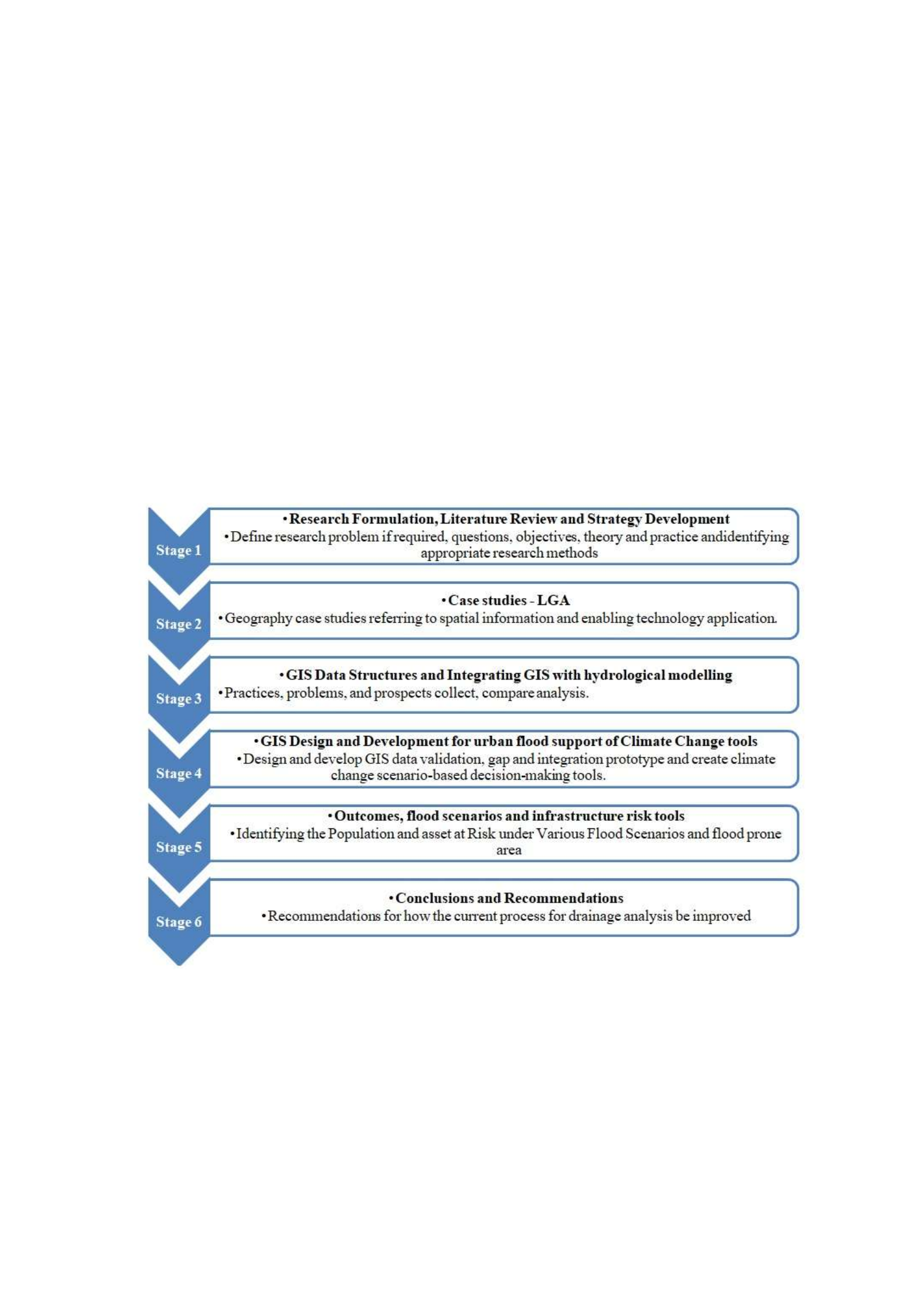
theory and practice that provides the foundation for the further improvement of an appropriate
theoretical framework for data collection and evaluation. This is possible due to the utilisation
of data and information collected through mixed research methods used at the second stage.
The third stage uses data and information gathered at the preceding step of the research. These
materials were obtained in the result of the development of a suite of flood management (FM)
stakeholder needs-focussed geospatial tools for the implementation within the Victorian FM
program. FM program created for Victoria is universal and, therefore, could be adapted to
other national and world-wide FM programs.
The data and information that were obtained during the first two stages are used for further
investigation at the third stage of the research. The outputs of the first three steps form the
fourth stage that includes the conclusions and recommendations of this thesis.
Figure 1.1: Proposed research design.
The final conclusions and recommendations of the present research paper will be based on the
synthesis and analysis of the first, second, and thirds stages. The first two stages present
information on the of a GIS-embedded hydrological model with machine learning techniques,
to improve administrative practices informed by flood hazard modelling. This information
includes a review of literature dedicated to the floodplain management in the Victoria setting.

Apart from that, it also consists of the user needs of spatial analysis and the concept of
hydrological modelling using Light Detection and Ranging (LiDAR).
The discussion presented in the third and fourth stages highlights the following topics:
• GIS functionalities in hydrological modelling and LiDAR data implementation for the
Victorian Council’s flood model;
• The importance of the spatial database for “on-request” hydrological modelling;
• Flood modelling through an examination of GIS datasets to detect the gaps in spatial
information and the essential characteristics;
• GIS in Water Resources with machine learning and Flood Risk Management;
Data used at the first and the second stages of the research focuses on flooding and floodplain
management in the Australian settings. The utilisation of LiDAR enables users to perform a
spatial investigation and a reasonable hydrological visualisation. The examination of GIS
functionalities in hydrological and LiDAR applications conducted at the third and fourth stages
shows the effects along the Victorian creek. These stages investigate the importance of GIS
database for ‘on-request’ hydrological examination and flood modelling over the use of spatial
datasets. This investigation allows to reveal the gaps in GIS information and indicate the
required characteristics of hydrology models for flood modelling. As a result, the fourth stage
will address the central problem of the present research and its objectives.
The knowledge gained from this project could be used to inform future FM and provide spatial
information infrastructure (SII) policy reforms in Victoria. Additionally, the results of the
research might close the previously mentioned policy-to-practice gaps related to the integration
of spatial decision-support for FM in Victoria.
Structure and Outline of the Thesis
Figure 1.2, presented below, reflect the structure of the thesis that is comprised of eight
chapters.

Figure 1.2: Structure of the thesis in relation to the objectives and research questions.
As it has already been stated, the first stage of the research is comprised of research
formulation, literature review and development of the strategy. Chapter 1 includes the
introduction and the theoretical framework of the thesis. It also described the problem, aim,
and questions of the research. The literature review on flooding, flood management, GIS and
Hydrological modelling could be found in Chapter 2 that answers the first and the second
research questions.
The second stage includes the case studies and the pilot study area that are described in chapter
3 “Pilot study area: City of Whittlesea (CoW)”. This section explains the standards for choosing
the pilot study area (the CoW) and hydrological and associated qualities of this area.
The focus of the third step of the thesis is directed at GIS data structures and processes for
integrating GIS with hydrological modelling. Therefore, chapter 4 discusses a case study aimed
at floodplain delineation using ArcHydro models, the choice of methods and user data
information needs in the context of local flood-risk analysis. It depicts the strategies and result
of spatial information linking for extricating overland flow through the property and reduces
the risk of flash flooding area utilizing GIS-embedded hydrological model with machine
learning techniques. In this chapter, the author also discusses the limitations in existing local
flood relevant spatial databases and answers the first and the third research questions.

Chapter 5 includes a case study on the watershed delineation of flood risk zones through
ArcSwat. The numerical models, introduced in this chapter, can simulate hydrological
processes by ArcSWAT. This chapter answers the research questions one and three.
Stage four involves GIS design and development for flood support of climate change tools.
Chapter 6 that is a case study on finding areas at risk of flooding in a downpour, presents the
results of the fourth step. This chapter applies the DEM dataset in GIS-embedded hydrological
model with machine learning techniques and answers the fourth and the fifth research
questions.
The penultimate stage of the thesis paper reveals the outcomes, flood scenarios and
infrastructure risk tools. Chapter 6 is comprised of a case study which develops an approach
for identifying infrastructure at risk from flooding, LiDAR modelling of flood inundation under
future and describes the current and future threats to infrastructure. Since chapter 7 is dedicated
to the discussion of GIS, remote sensing, and machine learning, it highlights the correlation
between the land-use changes and flash-flood potential. Chapter 7 answers the sixth research
questions.
The objective of the final stage of the research is to present conclusions and recommendations.
Chapter 8 that is the synthesis of findings, contains the results of this stage, conclusions and
recommendations for future research for improving Victoria’s flood management. In addition,
the last chapter provides suggestions for future research. Chapter 8 addresses the problem and
primary research objectives as well as the ways for future research.
Scope and the Key Assumptions of the Research
Undoubtedly, “spatial industry” faces certain limitations in term of the implementation of
policies directed at the mitigation of climate change (Douglas et al. 2008). This is illustrated
by the consequences of flood management practices used in Victoria in 2016. Thus, the critical
assumption of the research is that the modern models of floods have the capability to make
predictions only about urban areas. Furthermore, DEM datasets regard urban landscapes as a
stable during the whole time of the disaster. The conclusions that were reached in the fourth,
fifth, sixth and seventh chapters of the paper depict that it would be more beneficial to use
different tools to estimate the impact that floods would cause for infrastructural objects. The
sections from fourth to seventh bring novelty to the scientific community since the bridge the
gap of the limited research on simulation of floods impact on infrastructure.

Most importantly, there is no other research that would build an investigation of
interdependencies between flash-flood potential and land-use changes upon the combination
of GIS and hydrology model with machine learning. At the same time, it must be admitted that
the area that was used for the analysis in the paper was not affected by a flood. Nevertheless,
despite this fact, the presented procedure is universal and, consequently, could be applied in
any other area without exceptions.
Summary
The first chapter formulates the scientific and practical values of the research, its aims,
objectives, structure and could be viewed as the framework and the foundation for the
subsequent chapters. The second chapter reviews the literature on such topics as GIS,
hydrology, and information models that are applied for the analysis. The following four
sections describe the case study and by formulating the results not only answer the research
question but also bring novelty to the issued field of research.
Methods
The adoption and diffusion of decision support technology, with application to flood risk
management in Victoria, signify the conceptual basis for this thesis. Digital spatial information
modelling and the integration of the data and information used in the decision-support system
illustrate the technical basis of the paper.
In this research, the relevant data and information were gathered and analysed by the
application of a case study approach. As it was noticed by Serrao-Neumann et al. (2013), the
contextual analyses allow the researcher to look at natural phenomena in their typical setting
and use the information acquired by various methods and sources. Multiple disciplines, from
research on information systems operation, apply learning based on cases (Rajabifard et al.
2002, Mohammadi 2008, McDougall 2006). According to the previously mentioned scholars,
a case study approach is immensely suitable for investigation of the information systems field
because this filed continually innovates and undergoes changes (Rajabifard et al. 2002,
Mohammadi 2008, McDougall 2006).
Yin (2003) believes that when the phenomenon under study is identical to its context, the case
study research method also could be used. For instance, the complex interactions between
advanced technologies and organisations illustrate these circumstances. Hence, case study
research methods signify that the researcher asks “how and why” questions, focuses on the

contemporary phenomenon within a real-life context, and has the little opportunity to control
the events. Therefore, the application of contextual analyses is the most appropriate when the
investigator broadly defines research topics and covers not simply disengaged factors but
contextual or complex multivariate conditions (Yin 2003). Furthermore, according to Yin
(2003), it is essential to use opinions of the technology to understand the actual uses of the
technology and potential difficulties being faced by adopters if a case study refers to such
innovation as digital spatial information and enabling knowledge. The author of the current
research was an employee in the City of Whittlesea (CoW), and this experience allowed him
to make observations at the augmented level and investigate the dynamics of surrounding
organisational behaviour of the stakeholders towards enabling technology and geospatial data
(Yin 2003).
Figure 1.1 reflects the research design of the project that unites a framework for information
systems case study research approaches as it was described by Kaplan and Duchon (1988),
Lee and Heaney (2003), Onsrud et al. (1992) and Yin (2003). The first stage of the research
design is comprised of the detailed project formulation, including reviewing of the relevant
theory and practice that provides the foundation for the further improvement of an appropriate
theoretical framework for data collection and evaluation. This is possible due to the utilisation
of data and information collected through mixed research methods used at the second stage.
The third stage uses data and information gathered at the preceding step of the research. These
materials were obtained in the result of the development of a suite of flood management (FM)
stakeholder needs-focussed geospatial tools for the implementation within the Victorian FM
program. FM program created for Victoria is universal and, therefore, could be adapted to
other national and world-wide FM programs.
The data and information that were obtained during the first two stages are used for further
investigation at the third stage of the research. The outputs of the first three steps form the
fourth stage that includes the conclusions and recommendations of this thesis.

Figure 1.1: Proposed research design.
The final conclusions and recommendations of the present research paper will be based on the
synthesis and analysis of the first, second, and thirds stages. The first two stages present
information on the of a GIS-embedded hydrological model with machine learning techniques,
to improve administrative practices informed by flood hazard modelling. This information
includes a review of literature dedicated to the floodplain management in the Victoria setting.
Apart from that, it also consists of the user needs of spatial analysis and the concept of
hydrological modelling using Light Detection and Ranging (LiDAR).
The discussion presented in the third and fourth stages highlights the following topics:
• GIS functionalities in hydrological modelling and LiDAR data implementation for the
Victorian Council’s flood model;
• The importance of the spatial database for “on-request” hydrological modelling;
• Flood modelling through an examination of GIS datasets to detect the gaps in spatial
information and the essential characteristics;
• GIS in Water Resources with machine learning and Flood Risk Management;

Data used at the first and the second stages of the research focuses on flooding and floodplain
management in the Australian settings. The utilisation of LiDAR enables users to perform a
spatial investigation and a reasonable hydrological visualisation. The examination of GIS
functionalities in hydrological and LiDAR applications conducted at the third and fourth stages
shows the effects along the Victorian creek. These stages investigate the importance of GIS
database for ‘on-request’ hydrological examination and flood modelling over the use of spatial
datasets. This investigation allows to reveal the gaps in GIS information and indicate the
required characteristics of hydrology models for flood modelling. As a result, the fourth stage
will address the central problem of the present research and its objectives.
The knowledge gained from this project could be used to inform future FM and provide spatial
information infrastructure (SII) policy reforms in Victoria. Additionally, the results of the
research might close the previously mentioned policy-to-practice gaps related to the integration
of spatial decision-support for FM in Victoria.
Structure and Outline of the Thesis
Figure 1.2, presented below, reflect the structure of the thesis that is comprised of eight
chapters.
Figure 1.2: Structure of the thesis in relation to the objectives and research questions.

As it has already been stated, the first stage of the research is comprised of research
formulation, literature review and development of the strategy. Chapter 1 includes the
introduction and the theoretical framework of the thesis. It also described the problem, aim,
and questions of the research. The literature review on flooding, flood management, GIS and
Hydrological modelling could be found in Chapter 2 that answers the first and the second
research questions.
The second stage includes the case studies and the pilot study area that are described in chapter
3 “Pilot study area: City of Whittlesea (CoW)”. This section explains the standards for choosing
the pilot study area (the CoW) and hydrological and associated qualities of this area.
The focus of the third step of the thesis is directed at GIS data structures and processes for
integrating GIS with hydrological modelling. Therefore, chapter 4 discusses a case study aimed
at floodplain delineation using ArcHydro models, the choice of methods and user data
information needs in the context of local flood-risk analysis. It depicts the strategies and result
of spatial information linking for extricating overland flow through the property and reduces
the risk of flash flooding area utilizing GIS-embedded hydrological model with machine
learning techniques. In this chapter, the author also discusses the limitations in existing local
flood relevant spatial databases and answers the first and the third research questions.
Chapter 5 includes a case study on the watershed delineation of flood risk zones through
ArcSwat. The numerical models, introduced in this chapter, can simulate hydrological
processes by ArcSWAT. This chapter answers the research questions one and three.
Stage four involves GIS design and development for flood support of climate change tools.
Chapter 6 that is a case study on finding areas at risk of flooding in a downpour, presents the
results of the fourth step. This chapter applies the DEM dataset in GIS-embedded hydrological
model with machine learning techniques and answers the fourth and the fifth research
questions.
The penultimate stage of the thesis paper reveals the outcomes, flood scenarios and
infrastructure risk tools. Chapter 6 is comprised of a case study which develops an approach
for identifying infrastructure at risk from flooding, LiDAR modelling of flood inundation under
future and describes the current and future threats to infrastructure. Since chapter 7 is dedicated
to the discussion of GIS, remote sensing, and machine learning, it highlights the correlation
between the land-use changes and flash-flood potential. Chapter 7 answers the sixth research
questions.

The objective of the final stage of the research is to present conclusions and recommendations.
Chapter 8 that is the synthesis of findings, contains the results of this stage, conclusions and
recommendations for future research for improving Victoria’s flood management. In addition,
the last chapter provides suggestions for future research. Chapter 8 addresses the problem and
primary research objectives as well as the ways for future research.
Scope and the Key Assumptions of the Research
Undoubtedly, “spatial industry” faces certain limitations in term of the implementation of
policies directed at the mitigation of climate change (Douglas et al. 2008). This is illustrated
by the consequences of flood management practices used in Victoria in 2016. Thus, the critical
assumption of the research is that the modern models of floods have the capability to make
predictions only about urban areas. Furthermore, DEM datasets regard urban landscapes as a
stable during the whole time of the disaster. The conclusions that were reached in the fourth,
fifth, sixth and seventh chapters of the paper depict that it would be more beneficial to use
different tools to estimate the impact that floods would cause for infrastructural objects. The
sections from fourth to seventh bring novelty to the scientific community since the bridge the
gap of the limited research on simulation of floods impact on infrastructure.
Most importantly, there is no other research that would build an investigation of
interdependencies between flash-flood potential and land-use changes upon the combination
of GIS and hydrology model with machine learning. At the same time, it must be admitted that
the area that was used for the analysis in the paper was not affected by a flood. Nevertheless,
despite this fact, the presented procedure is universal and, consequently, could be applied in
any other area without exceptions.
Summary
The first chapter formulates the scientific and practical values of the research, its aims,
objectives, structure and could be viewed as the framework and the foundation for the
subsequent chapters. The second chapter reviews the literature on such topics as GIS,
hydrology, and information models that are applied for the analysis. The following four
sections describe the case study and by formulating the results not only answer the research
question but also bring novelty to the issued field of research.
Methods

The adoption and diffusion of decision support technology, with application to flood risk
management in Victoria, signify the conceptual basis for this thesis. Digital spatial information
modelling and the integration of the data and information used in the decision-support system
illustrate the technical basis of the paper.
In this research, the relevant data and information were gathered and analysed by the
application of a case study approach. As it was noticed by Serrao-Neumann et al. (2013), the
contextual analyses allow the researcher to look at natural phenomena in their typical setting
and use the information acquired by various methods and sources. Multiple disciplines, from
research on information systems operation, apply learning based on cases (Rajabifard et al.
2002, Mohammadi 2008, McDougall 2006). According to the previously mentioned scholars,
a case study approach is immensely suitable for investigation of the information systems field
because this filed continually innovates and undergoes changes (Rajabifard et al. 2002,
Mohammadi 2008, McDougall 2006).
Yin (2003) believes that when the phenomenon under study is identical to its context, the case
study research method also could be used. For instance, the complex interactions between
advanced technologies and organisations illustrate these circumstances. Hence, case study
research methods signify that the researcher asks “how and why” questions, focuses on the
contemporary phenomenon within a real-life context, and has the little opportunity to control
the events. Therefore, the application of contextual analyses is the most appropriate when the
investigator broadly defines research topics and covers not simply disengaged factors but
contextual or complex multivariate conditions (Yin 2003). Furthermore, according to Yin
(2003), it is essential to use opinions of the technology to understand the actual uses of the
technology and potential difficulties being faced by adopters if a case study refers to such
innovation as digital spatial information and enabling knowledge. The author of the current
research was an employee in the City of Whittlesea (CoW), and this experience allowed him
to make observations at the augmented level and investigate the dynamics of surrounding
organisational behaviour of the stakeholders towards enabling technology and geospatial data
(Yin 2003).
Figure 1.1 reflects the research design of the project that unites a framework for information
systems case study research approaches as it was described by Kaplan and Duchon (1988),
Lee and Heaney (2003), Onsrud et al. (1992) and Yin (2003). The first stage of the research
design is comprised of the detailed project formulation, including reviewing of the relevant

theory and practice that provides the foundation for the further improvement of an appropriate
theoretical framework for data collection and evaluation. This is possible due to the utilisation
of data and information collected through mixed research methods used at the second stage.
The third stage uses data and information gathered at the preceding step of the research. These
materials were obtained in the result of the development of a suite of flood management (FM)
stakeholder needs-focussed geospatial tools for the implementation within the Victorian FM
program. FM program created for Victoria is universal and, therefore, could be adapted to
other national and world-wide FM programs.
The data and information that were obtained during the first two stages are used for further
investigation at the third stage of the research. The outputs of the first three steps form the
fourth stage that includes the conclusions and recommendations of this thesis.
Figure 1.1: Proposed research design.
The final conclusions and recommendations of the present research paper will be based on the
synthesis and analysis of the first, second, and thirds stages. The first two stages present
information on the of a GIS-embedded hydrological model with machine learning techniques,
to improve administrative practices informed by flood hazard modelling. This information
includes a review of literature dedicated to the floodplain management in the Victoria setting.

Apart from that, it also consists of the user needs of spatial analysis and the concept of
hydrological modelling using Light Detection and Ranging (LiDAR).
The discussion presented in the third and fourth stages highlights the following topics:
• GIS functionalities in hydrological modelling and LiDAR data implementation for the
Victorian Council’s flood model;
• The importance of the spatial database for “on-request” hydrological modelling;
• Flood modelling through an examination of GIS datasets to detect the gaps in spatial
information and the essential characteristics;
• GIS in Water Resources with machine learning and Flood Risk Management;
Data used at the first and the second stages of the research focuses on flooding and floodplain
management in the Australian settings. The utilisation of LiDAR enables users to perform a
spatial investigation and a reasonable hydrological visualisation. The examination of GIS
functionalities in hydrological and LiDAR applications conducted at the third and fourth stages
shows the effects along the Victorian creek. These stages investigate the importance of GIS
database for ‘on-request’ hydrological examination and flood modelling over the use of spatial
datasets. This investigation allows to reveal the gaps in GIS information and indicate the
required characteristics of hydrology models for flood modelling. As a result, the fourth stage
will address the central problem of the present research and its objectives.
The knowledge gained from this project could be used to inform future FM and provide spatial
information infrastructure (SII) policy reforms in Victoria. Additionally, the results of the
research might close the previously mentioned policy-to-practice gaps related to the integration
of spatial decision-support for FM in Victoria.
Structure and Outline of the Thesis
Figure 1.2, presented below, reflect the structure of the thesis that is comprised of eight
chapters.

Figure 1.2: Structure of the thesis in relation to the objectives and research questions.
As it has already been stated, the first stage of the research is comprised of research
formulation, literature review and development of the strategy. Chapter 1 includes the
introduction and the theoretical framework of the thesis. It also described the problem, aim,
and questions of the research. The literature review on flooding, flood management, GIS and
Hydrological modelling could be found in Chapter 2 that answers the first and the second
research questions.
The second stage includes the case studies and the pilot study area that are described in chapter
3 “Pilot study area: City of Whittlesea (CoW)”. This section explains the standards for choosing
the pilot study area (the CoW) and hydrological and associated qualities of this area.
The focus of the third step of the thesis is directed at GIS data structures and processes for
integrating GIS with hydrological modelling. Therefore, chapter 4 discusses a case study aimed
at floodplain delineation using ArcHydro models, the choice of methods and user data
information needs in the context of local flood-risk analysis. It depicts the strategies and result
of spatial information linking for extricating overland flow through the property and reduces
the risk of flash flooding area utilizing GIS-embedded hydrological model with machine
learning techniques. In this chapter, the author also discusses the limitations in existing local
flood relevant spatial databases and answers the first and the third research questions.

Chapter 5 includes a case study on the watershed delineation of flood risk zones through
ArcSwat. The numerical models, introduced in this chapter, can simulate hydrological
processes by ArcSWAT. This chapter answers the research questions one and three.
Stage four involves GIS design and development for flood support of climate change tools.
Chapter 6 that is a case study on finding areas at risk of flooding in a downpour, presents the
results of the fourth step. This chapter applies the DEM dataset in GIS-embedded hydrological
model with machine learning techniques and answers the fourth and the fifth research
questions.
The penultimate stage of the thesis paper reveals the outcomes, flood scenarios and
infrastructure risk tools. Chapter 6 is comprised of a case study which develops an approach
for identifying infrastructure at risk from flooding, LiDAR modelling of flood inundation under
future and describes the current and future threats to infrastructure. Since chapter 7 is dedicated
to the discussion of GIS, remote sensing, and machine learning, it highlights the correlation
between the land-use changes and flash-flood potential. Chapter 7 answers the sixth research
questions.
The objective of the final stage of the research is to present conclusions and recommendations.
Chapter 8 that is the synthesis of findings, contains the results of this stage, conclusions and
recommendations for future research for improving Victoria’s flood management. In addition,
the last chapter provides suggestions for future research. Chapter 8 addresses the problem and
primary research objectives as well as the ways for future research.
Scope and the Key Assumptions of the Research
Undoubtedly, “spatial industry” faces certain limitations in term of the implementation of
policies directed at the mitigation of climate change (Douglas et al. 2008). This is illustrated
by the consequences of flood management practices used in Victoria in 2016. Thus, the critical
assumption of the research is that the modern models of floods have the capability to make
predictions only about urban areas. Furthermore, DEM datasets regard urban landscapes as a
stable during the whole time of the disaster. The conclusions that were reached in the fourth,
fifth, sixth and seventh chapters of the paper depict that it would be more beneficial to use
different tools to estimate the impact that floods would cause for infrastructural objects. The
sections from fourth to seventh bring novelty to the scientific community since the bridge the
gap of the limited research on simulation of floods impact on infrastructure.

Most importantly, there is no other research that would build an investigation of
interdependencies between flash-flood potential and land-use changes upon the combination
of GIS and hydrology model with machine learning. At the same time, it must be admitted that
the area that was used for the analysis in the paper was not affected by a flood. Nevertheless,
despite this fact, the presented procedure is universal and, consequently, could be applied in
any other area without exceptions.
Summary
The first chapter formulates the scientific and practical values of the research, its aims,
objectives, structure and could be viewed as the framework and the foundation for the
subsequent chapters. The second chapter reviews the literature on such topics as GIS,
hydrology, and information models that are applied for the analysis. The following four
sections describe the case study and by formulating the results not only answer the research
question but also bring novelty to the issued field of research.
Methods
The adoption and diffusion of decision support technology, with application to flood risk
management in Victoria, signify the conceptual basis for this thesis. Digital spatial information
modelling and the integration of the data and information used in the decision-support system
illustrate the technical basis of the paper.
In this research, the relevant data and information were gathered and analysed by the
application of a case study approach. As it was noticed by Serrao-Neumann et al. (2013), the
contextual analyses allow the researcher to look at natural phenomena in their typical setting
and use the information acquired by various methods and sources. Multiple disciplines, from
research on information systems operation, apply learning based on cases (Rajabifard et al.
2002, Mohammadi 2008, McDougall 2006). According to the previously mentioned scholars,
a case study approach is immensely suitable for investigation of the information systems field
because this filed continually innovates and undergoes changes (Rajabifard et al. 2002,
Mohammadi 2008, McDougall 2006).
Yin (2003) believes that when the phenomenon under study is identical to its context, the case
study research method also could be used. For instance, the complex interactions between
advanced technologies and organisations illustrate these circumstances. Hence, case study
research methods signify that the researcher asks “how and why” questions, focuses on the

contemporary phenomenon within a real-life context, and has the little opportunity to control
the events. Therefore, the application of contextual analyses is the most appropriate when the
investigator broadly defines research topics and covers not simply disengaged factors but
contextual or complex multivariate conditions (Yin 2003). Furthermore, according to Yin
(2003), it is essential to use opinions of the technology to understand the actual uses of the
technology and potential difficulties being faced by adopters if a case study refers to such
innovation as digital spatial information and enabling knowledge. The author of the current
research was an employee in the City of Whittlesea (CoW), and this experience allowed him
to make observations at the augmented level and investigate the dynamics of surrounding
organisational behaviour of the stakeholders towards enabling technology and geospatial data
(Yin 2003).
Figure 1.1 reflects the research design of the project that unites a framework for information
systems case study research approaches as it was described by Kaplan and Duchon (1988),
Lee and Heaney (2003), Onsrud et al. (1992) and Yin (2003). The first stage of the research
design is comprised of the detailed project formulation, including reviewing of the relevant
theory and practice that provides the foundation for the further improvement of an appropriate
theoretical framework for data collection and evaluation. This is possible due to the utilisation
of data and information collected through mixed research methods used at the second stage.
The third stage uses data and information gathered at the preceding step of the research. These
materials were obtained in the result of the development of a suite of flood management (FM)
stakeholder needs-focussed geospatial tools for the implementation within the Victorian FM
program. FM program created for Victoria is universal and, therefore, could be adapted to
other national and world-wide FM programs.
The data and information that were obtained during the first two stages are used for further
investigation at the third stage of the research. The outputs of the first three steps form the
fourth stage that includes the conclusions and recommendations of this thesis.

Figure 1.1: Proposed research design.
The final conclusions and recommendations of the present research paper will be based on the
synthesis and analysis of the first, second, and thirds stages. The first two stages present
information on the of a GIS-embedded hydrological model with machine learning techniques,
to improve administrative practices informed by flood hazard modelling. This information
includes a review of literature dedicated to the floodplain management in the Victoria setting.
Apart from that, it also consists of the user needs of spatial analysis and the concept of
hydrological modelling using Light Detection and Ranging (LiDAR).
The discussion presented in the third and fourth stages highlights the following topics:
• GIS functionalities in hydrological modelling and LiDAR data implementation for the
Victorian Council’s flood model;
• The importance of the spatial database for “on-request” hydrological modelling;
• Flood modelling through an examination of GIS datasets to detect the gaps in spatial
information and the essential characteristics;
• GIS in Water Resources with machine learning and Flood Risk Management;

Data used at the first and the second stages of the research focuses on flooding and floodplain
management in the Australian settings. The utilisation of LiDAR enables users to perform a
spatial investigation and a reasonable hydrological visualisation. The examination of GIS
functionalities in hydrological and LiDAR applications conducted at the third and fourth stages
shows the effects along the Victorian creek. These stages investigate the importance of GIS
database for ‘on-request’ hydrological examination and flood modelling over the use of spatial
datasets. This investigation allows to reveal the gaps in GIS information and indicate the
required characteristics of hydrology models for flood modelling. As a result, the fourth stage
will address the central problem of the present research and its objectives.
The knowledge gained from this project could be used to inform future FM and provide spatial
information infrastructure (SII) policy reforms in Victoria. Additionally, the results of the
research might close the previously mentioned policy-to-practice gaps related to the integration
of spatial decision-support for FM in Victoria.
Structure and Outline of the Thesis
Figure 1.2, presented below, reflect the structure of the thesis that is comprised of eight
chapters.
Figure 1.2: Structure of the thesis in relation to the objectives and research questions.

As it has already been stated, the first stage of the research is comprised of research
formulation, literature review and development of the strategy. Chapter 1 includes the
introduction and the theoretical framework of the thesis. It also described the problem, aim,
and questions of the research. The literature review on flooding, flood management, GIS and
Hydrological modelling could be found in Chapter 2 that answers the first and the second
research questions.
The second stage includes the case studies and the pilot study area that are described in chapter
3 “Pilot study area: City of Whittlesea (CoW)”. This section explains the standards for choosing
the pilot study area (the CoW) and hydrological and associated qualities of this area.
The focus of the third step of the thesis is directed at GIS data structures and processes for
integrating GIS with hydrological modelling. Therefore, chapter 4 discusses a case study aimed
at floodplain delineation using ArcHydro models, the choice of methods and user data
information needs in the context of local flood-risk analysis. It depicts the strategies and result
of spatial information linking for extricating overland flow through the property and reduces
the risk of flash flooding area utilizing GIS-embedded hydrological model with machine
learning techniques. In this chapter, the author also discusses the limitations in existing local
flood relevant spatial databases and answers the first and the third research questions.
Chapter 5 includes a case study on the watershed delineation of flood risk zones through
ArcSwat. The numerical models, introduced in this chapter, can simulate hydrological
processes by ArcSWAT. This chapter answers the research questions one and three.
Stage four involves GIS design and development for flood support of climate change tools.
Chapter 6 that is a case study on finding areas at risk of flooding in a downpour, presents the
results of the fourth step. This chapter applies the DEM dataset in GIS-embedded hydrological
model with machine learning techniques and answers the fourth and the fifth research
questions.
The penultimate stage of the thesis paper reveals the outcomes, flood scenarios and
infrastructure risk tools. Chapter 6 is comprised of a case study which develops an approach
for identifying infrastructure at risk from flooding, LiDAR modelling of flood inundation under
future and describes the current and future threats to infrastructure. Since chapter 7 is dedicated
to the discussion of GIS, remote sensing, and machine learning, it highlights the correlation
between the land-use changes and flash-flood potential. Chapter 7 answers the sixth research
questions.

The objective of the final stage of the research is to present conclusions and recommendations.
Chapter 8 that is the synthesis of findings, contains the results of this stage, conclusions and
recommendations for future research for improving Victoria’s flood management. In addition,
the last chapter provides suggestions for future research. Chapter 8 addresses the problem and
primary research objectives as well as the ways for future research.
Scope and the Key Assumptions of the Research
Undoubtedly, “spatial industry” faces certain limitations in term of the implementation of
policies directed at the mitigation of climate change (Douglas et al. 2008). This is illustrated
by the consequences of flood management practices used in Victoria in 2016. Thus, the critical
assumption of the research is that the modern models of floods have the capability to make
predictions only about urban areas. Furthermore, DEM datasets regard urban landscapes as a
stable during the whole time of the disaster. The conclusions that were reached in the fourth,
fifth, sixth and seventh chapters of the paper depict that it would be more beneficial to use
different tools to estimate the impact that floods would cause for infrastructural objects. The
sections from fourth to seventh bring novelty to the scientific community since the bridge the
gap of the limited research on simulation of floods impact on infrastructure.
Most importantly, there is no other research that would build an investigation of
interdependencies between flash-flood potential and land-use changes upon the combination
of GIS and hydrology model with machine learning. At the same time, it must be admitted that
the area that was used for the analysis in the paper was not affected by a flood. Nevertheless,
despite this fact, the presented procedure is universal and, consequently, could be applied in
any other area without exceptions.
Summary
The first chapter formulates the scientific and practical values of the research, its aims,
objectives, structure and could be viewed as the framework and the foundation for the
subsequent chapters. The second chapter reviews the literature on such topics as GIS,
hydrology, and information models that are applied for the analysis. The following four
sections describe the case study and by formulating the results not only answer the research
question but also bring novelty to the issued field of research.
Methods

The adoption and diffusion of decision support technology, with application to flood risk
management in Victoria, signify the conceptual basis for this thesis. Digital spatial information
modelling and the integration of the data and information used in the decision-support system
illustrate the technical basis of the paper.
In this research, the relevant data and information were gathered and analysed by the
application of a case study approach. As it was noticed by Serrao-Neumann et al. (2013), the
contextual analyses allow the researcher to look at natural phenomena in their typical setting
and use the information acquired by various methods and sources. Multiple disciplines, from
research on information systems operation, apply learning based on cases (Rajabifard et al.
2002, Mohammadi 2008, McDougall 2006). According to the previously mentioned scholars,
a case study approach is immensely suitable for investigation of the information systems field
because this filed continually innovates and undergoes changes (Rajabifard et al. 2002,
Mohammadi 2008, McDougall 2006).
Yin (2003) believes that when the phenomenon under study is identical to its context, the case
study research method also could be used. For instance, the complex interactions between
advanced technologies and organisations illustrate these circumstances. Hence, case study
research methods signify that the researcher asks “how and why” questions, focuses on the
contemporary phenomenon within a real-life context, and has the little opportunity to control
the events. Therefore, the application of contextual analyses is the most appropriate when the
investigator broadly defines research topics and covers not simply disengaged factors but
contextual or complex multivariate conditions (Yin 2003). Furthermore, according to Yin
(2003), it is essential to use opinions of the technology to understand the actual uses of the
technology and potential difficulties being faced by adopters if a case study refers to such
innovation as digital spatial information and enabling knowledge. The author of the current
research was an employee in the City of Whittlesea (CoW), and this experience allowed him
to make observations at the augmented level and investigate the dynamics of surrounding
organisational behaviour of the stakeholders towards enabling technology and geospatial data
(Yin 2003).
Figure 1.1 reflects the research design of the project that unites a framework for information
systems case study research approaches as it was described by Kaplan and Duchon (1988),
Lee and Heaney (2003), Onsrud et al. (1992) and Yin (2003). The first stage of the research
design is comprised of the detailed project formulation, including reviewing of the relevant

theory and practice that provides the foundation for the further improvement of an appropriate
theoretical framework for data collection and evaluation. This is possible due to the utilisation
of data and information collected through mixed research methods used at the second stage.
The third stage uses data and information gathered at the preceding step of the research. These
materials were obtained in the result of the development of a suite of flood management (FM)
stakeholder needs-focussed geospatial tools for the implementation within the Victorian FM
program. FM program created for Victoria is universal and, therefore, could be adapted to
other national and world-wide FM programs.
The data and information that were obtained during the first two stages are used for further
investigation at the third stage of the research. The outputs of the first three steps form the
fourth stage that includes the conclusions and recommendations of this thesis.
Figure 1.1: Proposed research design.
The final conclusions and recommendations of the present research paper will be based on the
synthesis and analysis of the first, second, and thirds stages. The first two stages present
information on the of a GIS-embedded hydrological model with machine learning techniques,
to improve administrative practices informed by flood hazard modelling. This information
includes a review of literature dedicated to the floodplain management in the Victoria setting.

Apart from that, it also consists of the user needs of spatial analysis and the concept of
hydrological modelling using Light Detection and Ranging (LiDAR).
The discussion presented in the third and fourth stages highlights the following topics:
• GIS functionalities in hydrological modelling and LiDAR data implementation for the
Victorian Council’s flood model;
• The importance of the spatial database for “on-request” hydrological modelling;
• Flood modelling through an examination of GIS datasets to detect the gaps in spatial
information and the essential characteristics;
• GIS in Water Resources with machine learning and Flood Risk Management;
Data used at the first and the second stages of the research focuses on flooding and floodplain
management in the Australian settings. The utilisation of LiDAR enables users to perform a
spatial investigation and a reasonable hydrological visualisation. The examination of GIS
functionalities in hydrological and LiDAR applications conducted at the third and fourth stages
shows the effects along the Victorian creek. These stages investigate the importance of GIS
database for ‘on-request’ hydrological examination and flood modelling over the use of spatial
datasets. This investigation allows to reveal the gaps in GIS information and indicate the
required characteristics of hydrology models for flood modelling. As a result, the fourth stage
will address the central problem of the present research and its objectives.
The knowledge gained from this project could be used to inform future FM and provide spatial
information infrastructure (SII) policy reforms in Victoria. Additionally, the results of the
research might close the previously mentioned policy-to-practice gaps related to the integration
of spatial decision-support for FM in Victoria.
Structure and Outline of the Thesis
Figure 1.2, presented below, reflect the structure of the thesis that is comprised of eight
chapters.

Figure 1.2: Structure of the thesis in relation to the objectives and research questions.
As it has already been stated, the first stage of the research is comprised of research
formulation, literature review and development of the strategy. Chapter 1 includes the
introduction and the theoretical framework of the thesis. It also described the problem, aim,
and questions of the research. The literature review on flooding, flood management, GIS and
Hydrological modelling could be found in Chapter 2 that answers the first and the second
research questions.
The second stage includes the case studies and the pilot study area that are described in chapter
3 “Pilot study area: City of Whittlesea (CoW)”. This section explains the standards for choosing
the pilot study area (the CoW) and hydrological and associated qualities of this area.
The focus of the third step of the thesis is directed at GIS data structures and processes for
integrating GIS with hydrological modelling. Therefore, chapter 4 discusses a case study aimed
at floodplain delineation using ArcHydro models, the choice of methods and user data
information needs in the context of local flood-risk analysis. It depicts the strategies and result
of spatial information linking for extricating overland flow through the property and reduces
the risk of flash flooding area utilizing GIS-embedded hydrological model with machine
learning techniques. In this chapter, the author also discusses the limitations in existing local
flood relevant spatial databases and answers the first and the third research questions.

Chapter 5 includes a case study on the watershed delineation of flood risk zones through
ArcSwat. The numerical models, introduced in this chapter, can simulate hydrological
processes by ArcSWAT. This chapter answers the research questions one and three.
Stage four involves GIS design and development for flood support of climate change tools.
Chapter 6 that is a case study on finding areas at risk of flooding in a downpour, presents the
results of the fourth step. This chapter applies the DEM dataset in GIS-embedded hydrological
model with machine learning techniques and answers the fourth and the fifth research
questions.
The penultimate stage of the thesis paper reveals the outcomes, flood scenarios and
infrastructure risk tools. Chapter 6 is comprised of a case study which develops an approach
for identifying infrastructure at risk from flooding, LiDAR modelling of flood inundation under
future and describes the current and future threats to infrastructure. Since chapter 7 is dedicated
to the discussion of GIS, remote sensing, and machine learning, it highlights the correlation
between the land-use changes and flash-flood potential. Chapter 7 answers the sixth research
questions.
The objective of the final stage of the research is to present conclusions and recommendations.
Chapter 8 that is the synthesis of findings, contains the results of this stage, conclusions and
recommendations for future research for improving Victoria’s flood management. In addition,
the last chapter provides suggestions for future research. Chapter 8 addresses the problem and
primary research objectives as well as the ways for future research.
Scope and the Key Assumptions of the Research
Undoubtedly, “spatial industry” faces certain limitations in term of the implementation of
policies directed at the mitigation of climate change (Douglas et al. 2008). This is illustrated
by the consequences of flood management practices used in Victoria in 2016. Thus, the critical
assumption of the research is that the modern models of floods have the capability to make
predictions only about urban areas. Furthermore, DEM datasets regard urban landscapes as a
stable during the whole time of the disaster. The conclusions that were reached in the fourth,
fifth, sixth and seventh chapters of the paper depict that it would be more beneficial to use
different tools to estimate the impact that floods would cause for infrastructural objects. The
sections from fourth to seventh bring novelty to the scientific community since the bridge the
gap of the limited research on simulation of floods impact on infrastructure.

Most importantly, there is no other research that would build an investigation of
interdependencies between flash-flood potential and land-use changes upon the combination
of GIS and hydrology model with machine learning. At the same time, it must be admitted that
the area that was used for the analysis in the paper was not affected by a flood. Nevertheless,
despite this fact, the presented procedure is universal and, consequently, could be applied in
any other area without exceptions.
Summary
The first chapter formulates the scientific and practical values of the research, its aims,
objectives, structure and could be viewed as the framework and the foundation for the
subsequent chapters. The second chapter reviews the literature on such topics as GIS,
hydrology, and information models that are applied for the analysis. The following four
sections describe the case study and by formulating the results not only answer the research
question but also bring novelty to the issued field of research.
Methods
The adoption and diffusion of decision support technology, with application to flood risk
management in Victoria, signify the conceptual basis for this thesis. Digital spatial information
modelling and the integration of the data and information used in the decision-support system
illustrate the technical basis of the paper.
In this research, the relevant data and information were gathered and analysed by the
application of a case study approach. As it was noticed by Serrao-Neumann et al. (2013), the
contextual analyses allow the researcher to look at natural phenomena in their typical setting
and use the information acquired by various methods and sources. Multiple disciplines, from
research on information systems operation, apply learning based on cases (Rajabifard et al.
2002, Mohammadi 2008, McDougall 2006). According to the previously mentioned scholars,
a case study approach is immensely suitable for investigation of the information systems field
because this filed continually innovates and undergoes changes (Rajabifard et al. 2002,
Mohammadi 2008, McDougall 2006).
Yin (2003) believes that when the phenomenon under study is identical to its context, the case
study research method also could be used. For instance, the complex interactions between
advanced technologies and organisations illustrate these circumstances. Hence, case study
research methods signify that the researcher asks “how and why” questions, focuses on the

contemporary phenomenon within a real-life context, and has the little opportunity to control
the events. Therefore, the application of contextual analyses is the most appropriate when the
investigator broadly defines research topics and covers not simply disengaged factors but
contextual or complex multivariate conditions (Yin 2003). Furthermore, according to Yin
(2003), it is essential to use opinions of the technology to understand the actual uses of the
technology and potential difficulties being faced by adopters if a case study refers to such
innovation as digital spatial information and enabling knowledge. The author of the current
research was an employee in the City of Whittlesea (CoW), and this experience allowed him
to make observations at the augmented level and investigate the dynamics of surrounding
organisational behaviour of the stakeholders towards enabling technology and geospatial data
(Yin 2003).
Figure 1.1 reflects the research design of the project that unites a framework for information
systems case study research approaches as it was described by Kaplan and Duchon (1988),
Lee and Heaney (2003), Onsrud et al. (1992) and Yin (2003). The first stage of the research
design is comprised of the detailed project formulation, including reviewing of the relevant
theory and practice that provides the foundation for the further improvement of an appropriate
theoretical framework for data collection and evaluation. This is possible due to the utilisation
of data and information collected through mixed research methods used at the second stage.
The third stage uses data and information gathered at the preceding step of the research. These
materials were obtained in the result of the development of a suite of flood management (FM)
stakeholder needs-focussed geospatial tools for the implementation within the Victorian FM
program. FM program created for Victoria is universal and, therefore, could be adapted to
other national and world-wide FM programs.
The data and information that were obtained during the first two stages are used for further
investigation at the third stage of the research. The outputs of the first three steps form the
fourth stage that includes the conclusions and recommendations of this thesis.

Figure 1.1: Proposed research design.
The final conclusions and recommendations of the present research paper will be based on the
synthesis and analysis of the first, second, and thirds stages. The first two stages present
information on the of a GIS-embedded hydrological model with machine learning techniques,
to improve administrative practices informed by flood hazard modelling. This information
includes a review of literature dedicated to the floodplain management in the Victoria setting.
Apart from that, it also consists of the user needs of spatial analysis and the concept of
hydrological modelling using Light Detection and Ranging (LiDAR).
The discussion presented in the third and fourth stages highlights the following topics:
• GIS functionalities in hydrological modelling and LiDAR data implementation for the
Victorian Council’s flood model;
• The importance of the spatial database for “on-request” hydrological modelling;
• Flood modelling through an examination of GIS datasets to detect the gaps in spatial
information and the essential characteristics;
• GIS in Water Resources with machine learning and Flood Risk Management;

Data used at the first and the second stages of the research focuses on flooding and floodplain
management in the Australian settings. The utilisation of LiDAR enables users to perform a
spatial investigation and a reasonable hydrological visualisation. The examination of GIS
functionalities in hydrological and LiDAR applications conducted at the third and fourth stages
shows the effects along the Victorian creek. These stages investigate the importance of GIS
database for ‘on-request’ hydrological examination and flood modelling over the use of spatial
datasets. This investigation allows to reveal the gaps in GIS information and indicate the
required characteristics of hydrology models for flood modelling. As a result, the fourth stage
will address the central problem of the present research and its objectives.
The knowledge gained from this project could be used to inform future FM and provide spatial
information infrastructure (SII) policy reforms in Victoria. Additionally, the results of the
research might close the previously mentioned policy-to-practice gaps related to the integration
of spatial decision-support for FM in Victoria.
Structure and Outline of the Thesis
Figure 1.2, presented below, reflect the structure of the thesis that is comprised of eight
chapters.
Figure 1.2: Structure of the thesis in relation to the objectives and research questions.

As it has already been stated, the first stage of the research is comprised of research
formulation, literature review and development of the strategy. Chapter 1 includes the
introduction and the theoretical framework of the thesis. It also described the problem, aim,
and questions of the research. The literature review on flooding, flood management, GIS and
Hydrological modelling could be found in Chapter 2 that answers the first and the second
research questions.
The second stage includes the case studies and the pilot study area that are described in chapter
3 “Pilot study area: City of Whittlesea (CoW)”. This section explains the standards for choosing
the pilot study area (the CoW) and hydrological and associated qualities of this area.
The focus of the third step of the thesis is directed at GIS data structures and processes for
integrating GIS with hydrological modelling. Therefore, chapter 4 discusses a case study aimed
at floodplain delineation using ArcHydro models, the choice of methods and user data
information needs in the context of local flood-risk analysis. It depicts the strategies and result
of spatial information linking for extricating overland flow through the property and reduces
the risk of flash flooding area utilizing GIS-embedded hydrological model with machine
learning techniques. In this chapter, the author also discusses the limitations in existing local
flood relevant spatial databases and answers the first and the third research questions.
Chapter 5 includes a case study on the watershed delineation of flood risk zones through
ArcSwat. The numerical models, introduced in this chapter, can simulate hydrological
processes by ArcSWAT. This chapter answers the research questions one and three.
Stage four involves GIS design and development for flood support of climate change tools.
Chapter 6 that is a case study on finding areas at risk of flooding in a downpour, presents the
results of the fourth step. This chapter applies the DEM dataset in GIS-embedded hydrological
model with machine learning techniques and answers the fourth and the fifth research
questions.
The penultimate stage of the thesis paper reveals the outcomes, flood scenarios and
infrastructure risk tools. Chapter 6 is comprised of a case study which develops an approach
for identifying infrastructure at risk from flooding, LiDAR modelling of flood inundation under
future and describes the current and future threats to infrastructure. Since chapter 7 is dedicated
to the discussion of GIS, remote sensing, and machine learning, it highlights the correlation
between the land-use changes and flash-flood potential. Chapter 7 answers the sixth research
questions.

The objective of the final stage of the research is to present conclusions and recommendations.
Chapter 8 that is the synthesis of findings, contains the results of this stage, conclusions and
recommendations for future research for improving Victoria’s flood management. In addition,
the last chapter provides suggestions for future research. Chapter 8 addresses the problem and
primary research objectives as well as the ways for future research.
Scope and the Key Assumptions of the Research
Undoubtedly, “spatial industry” faces certain limitations in term of the implementation of
policies directed at the mitigation of climate change (Douglas et al. 2008). This is illustrated
by the consequences of flood management practices used in Victoria in 2016. Thus, the critical
assumption of the research is that the modern models of floods have the capability to make
predictions only about urban areas. Furthermore, DEM datasets regard urban landscapes as a
stable during the whole time of the disaster. The conclusions that were reached in the fourth,
fifth, sixth and seventh chapters of the paper depict that it would be more beneficial to use
different tools to estimate the impact that floods would cause for infrastructural objects. The
sections from fourth to seventh bring novelty to the scientific community since the bridge the
gap of the limited research on simulation of floods impact on infrastructure.
Most importantly, there is no other research that would build an investigation of
interdependencies between flash-flood potential and land-use changes upon the combination
of GIS and hydrology model with machine learning. At the same time, it must be admitted that
the area that was used for the analysis in the paper was not affected by a flood. Nevertheless,
despite this fact, the presented procedure is universal and, consequently, could be applied in
any other area without exceptions.
Summary
The first chapter formulates the scientific and practical values of the research, its aims,
objectives, structure and could be viewed as the framework and the foundation for the
subsequent chapters. The second chapter reviews the literature on such topics as GIS,
hydrology, and information models that are applied for the analysis. The following four
sections describe the case study and by formulating the results not only answer the research
question but also bring novelty to the issued field of research.
Methods

The adoption and diffusion of decision support technology, with application to flood risk
management in Victoria, signify the conceptual basis for this thesis. Digital spatial information
modelling and the integration of the data and information used in the decision-support system
illustrate the technical basis of the paper.
In this research, the relevant data and information were gathered and analysed by the
application of a case study approach. As it was noticed by Serrao-Neumann et al. (2013), the
contextual analyses allow the researcher to look at natural phenomena in their typical setting
and use the information acquired by various methods and sources. Multiple disciplines, from
research on information systems operation, apply learning based on cases (Rajabifard et al.
2002, Mohammadi 2008, McDougall 2006). According to the previously mentioned scholars,
a case study approach is immensely suitable for investigation of the information systems field
because this filed continually innovates and undergoes changes (Rajabifard et al. 2002,
Mohammadi 2008, McDougall 2006).
Yin (2003) believes that when the phenomenon under study is identical to its context, the case
study research method also could be used. For instance, the complex interactions between
advanced technologies and organisations illustrate these circumstances. Hence, case study
research methods signify that the researcher asks “how and why” questions, focuses on the
contemporary phenomenon within a real-life context, and has the little opportunity to control
the events. Therefore, the application of contextual analyses is the most appropriate when the
investigator broadly defines research topics and covers not simply disengaged factors but
contextual or complex multivariate conditions (Yin 2003). Furthermore, according to Yin
(2003), it is essential to use opinions of the technology to understand the actual uses of the
technology and potential difficulties being faced by adopters if a case study refers to such
innovation as digital spatial information and enabling knowledge. The author of the current
research was an employee in the City of Whittlesea (CoW), and this experience allowed him
to make observations at the augmented level and investigate the dynamics of surrounding
organisational behaviour of the stakeholders towards enabling technology and geospatial data
(Yin 2003).
Figure 1.1 reflects the research design of the project that unites a framework for information
systems case study research approaches as it was described by Kaplan and Duchon (1988),
Lee and Heaney (2003), Onsrud et al. (1992) and Yin (2003). The first stage of the research
design is comprised of the detailed project formulation, including reviewing of the relevant

theory and practice that provides the foundation for the further improvement of an appropriate
theoretical framework for data collection and evaluation. This is possible due to the utilisation
of data and information collected through mixed research methods used at the second stage.
The third stage uses data and information gathered at the preceding step of the research. These
materials were obtained in the result of the development of a suite of flood management (FM)
stakeholder needs-focussed geospatial tools for the implementation within the Victorian FM
program. FM program created for Victoria is universal and, therefore, could be adapted to
other national and world-wide FM programs.
The data and information that were obtained during the first two stages are used for further
investigation at the third stage of the research. The outputs of the first three steps form the
fourth stage that includes the conclusions and recommendations of this thesis.
Figure 1.1: Proposed research design.
The final conclusions and recommendations of the present research paper will be based on the
synthesis and analysis of the first, second, and thirds stages. The first two stages present
information on the of a GIS-embedded hydrological model with machine learning techniques,
to improve administrative practices informed by flood hazard modelling. This information
includes a review of literature dedicated to the floodplain management in the Victoria setting.

Apart from that, it also consists of the user needs of spatial analysis and the concept of
hydrological modelling using Light Detection and Ranging (LiDAR).
The discussion presented in the third and fourth stages highlights the following topics:
• GIS functionalities in hydrological modelling and LiDAR data implementation for the
Victorian Council’s flood model;
• The importance of the spatial database for “on-request” hydrological modelling;
• Flood modelling through an examination of GIS datasets to detect the gaps in spatial
information and the essential characteristics;
• GIS in Water Resources with machine learning and Flood Risk Management;
Data used at the first and the second stages of the research focuses on flooding and floodplain
management in the Australian settings. The utilisation of LiDAR enables users to perform a
spatial investigation and a reasonable hydrological visualisation. The examination of GIS
functionalities in hydrological and LiDAR applications conducted at the third and fourth stages
shows the effects along the Victorian creek. These stages investigate the importance of GIS
database for ‘on-request’ hydrological examination and flood modelling over the use of spatial
datasets. This investigation allows to reveal the gaps in GIS information and indicate the
required characteristics of hydrology models for flood modelling. As a result, the fourth stage
will address the central problem of the present research and its objectives.
The knowledge gained from this project could be used to inform future FM and provide spatial
information infrastructure (SII) policy reforms in Victoria. Additionally, the results of the
research might close the previously mentioned policy-to-practice gaps related to the integration
of spatial decision-support for FM in Victoria.
Structure and Outline of the Thesis
Figure 1.2, presented below, reflect the structure of the thesis that is comprised of eight
chapters.

Figure 1.2: Structure of the thesis in relation to the objectives and research questions.
As it has already been stated, the first stage of the research is comprised of research
formulation, literature review and development of the strategy. Chapter 1 includes the
introduction and the theoretical framework of the thesis. It also described the problem, aim,
and questions of the research. The literature review on flooding, flood management, GIS and
Hydrological modelling could be found in Chapter 2 that answers the first and the second
research questions.
The second stage includes the case studies and the pilot study area that are described in chapter
3 “Pilot study area: City of Whittlesea (CoW)”. This section explains the standards for choosing
the pilot study area (the CoW) and hydrological and associated qualities of this area.
The focus of the third step of the thesis is directed at GIS data structures and processes for
integrating GIS with hydrological modelling. Therefore, chapter 4 discusses a case study aimed
at floodplain delineation using ArcHydro models, the choice of methods and user data
information needs in the context of local flood-risk analysis. It depicts the strategies and result
of spatial information linking for extricating overland flow through the property and reduces
the risk of flash flooding area utilizing GIS-embedded hydrological model with machine
learning techniques. In this chapter, the author also discusses the limitations in existing local
flood relevant spatial databases and answers the first and the third research questions.

Chapter 5 includes a case study on the watershed delineation of flood risk zones through
ArcSwat. The numerical models, introduced in this chapter, can simulate hydrological
processes by ArcSWAT. This chapter answers the research questions one and three.
Stage four involves GIS design and development for flood support of climate change tools.
Chapter 6 that is a case study on finding areas at risk of flooding in a downpour, presents the
results of the fourth step. This chapter applies the DEM dataset in GIS-embedded hydrological
model with machine learning techniques and answers the fourth and the fifth research
questions.
The penultimate stage of the thesis paper reveals the outcomes, flood scenarios and
infrastructure risk tools. Chapter 6 is comprised of a case study which develops an approach
for identifying infrastructure at risk from flooding, LiDAR modelling of flood inundation under
future and describes the current and future threats to infrastructure. Since chapter 7 is dedicated
to the discussion of GIS, remote sensing, and machine learning, it highlights the correlation
between the land-use changes and flash-flood potential. Chapter 7 answers the sixth research
questions.
The objective of the final stage of the research is to present conclusions and recommendations.
Chapter 8 that is the synthesis of findings, contains the results of this stage, conclusions and
recommendations for future research for improving Victoria’s flood management. In addition,
the last chapter provides suggestions for future research. Chapter 8 addresses the problem and
primary research objectives as well as the ways for future research.
Scope and the Key Assumptions of the Research
Undoubtedly, “spatial industry” faces certain limitations in term of the implementation of
policies directed at the mitigation of climate change (Douglas et al. 2008). This is illustrated
by the consequences of flood management practices used in Victoria in 2016. Thus, the critical
assumption of the research is that the modern models of floods have the capability to make
predictions only about urban areas. Furthermore, DEM datasets regard urban landscapes as a
stable during the whole time of the disaster. The conclusions that were reached in the fourth,
fifth, sixth and seventh chapters of the paper depict that it would be more beneficial to use
different tools to estimate the impact that floods would cause for infrastructural objects. The
sections from fourth to seventh bring novelty to the scientific community since the bridge the
gap of the limited research on simulation of floods impact on infrastructure.

Most importantly, there is no other research that would build an investigation of
interdependencies between flash-flood potential and land-use changes upon the combination
of GIS and hydrology model with machine learning. At the same time, it must be admitted that
the area that was used for the analysis in the paper was not affected by a flood. Nevertheless,
despite this fact, the presented procedure is universal and, consequently, could be applied in
any other area without exceptions.
Summary
The first chapter formulates the scientific and practical values of the research, its aims,
objectives, structure and could be viewed as the framework and the foundation for the
subsequent chapters. The second chapter reviews the literature on such topics as GIS,
hydrology, and information models that are applied for the analysis. The following four
sections describe the case study and by formulating the results not only answer the research
question but also bring novelty to the issued field of research.
Methods
The adoption and diffusion of decision support technology, with application to flood risk
management in Victoria, signify the conceptual basis for this thesis. Digital spatial information
modelling and the integration of the data and information used in the decision-support system
illustrate the technical basis of the paper.
In this research, the relevant data and information were gathered and analysed by the
application of a case study approach. As it was noticed by Serrao-Neumann et al. (2013), the
contextual analyses allow the researcher to look at natural phenomena in their typical setting
and use the information acquired by various methods and sources. Multiple disciplines, from
research on information systems operation, apply learning based on cases (Rajabifard et al.
2002, Mohammadi 2008, McDougall 2006). According to the previously mentioned scholars,
a case study approach is immensely suitable for investigation of the information systems field
because this filed continually innovates and undergoes changes (Rajabifard et al. 2002,
Mohammadi 2008, McDougall 2006).
Yin (2003) believes that when the phenomenon under study is identical to its context, the case
study research method also could be used. For instance, the complex interactions between
advanced technologies and organisations illustrate these circumstances. Hence, case study
research methods signify that the researcher asks “how and why” questions, focuses on the

contemporary phenomenon within a real-life context, and has the little opportunity to control
the events. Therefore, the application of contextual analyses is the most appropriate when the
investigator broadly defines research topics and covers not simply disengaged factors but
contextual or complex multivariate conditions (Yin 2003). Furthermore, according to Yin
(2003), it is essential to use opinions of the technology to understand the actual uses of the
technology and potential difficulties being faced by adopters if a case study refers to such
innovation as digital spatial information and enabling knowledge. The author of the current
research was an employee in the City of Whittlesea (CoW), and this experience allowed him
to make observations at the augmented level and investigate the dynamics of surrounding
organisational behaviour of the stakeholders towards enabling technology and geospatial data
(Yin 2003).
Figure 1.1 reflects the research design of the project that unites a framework for information
systems case study research approaches as it was described by Kaplan and Duchon (1988),
Lee and Heaney (2003), Onsrud et al. (1992) and Yin (2003). The first stage of the research
design is comprised of the detailed project formulation, including reviewing of the relevant
theory and practice that provides the foundation for the further improvement of an appropriate
theoretical framework for data collection and evaluation. This is possible due to the utilisation
of data and information collected through mixed research methods used at the second stage.
The third stage uses data and information gathered at the preceding step of the research. These
materials were obtained in the result of the development of a suite of flood management (FM)
stakeholder needs-focussed geospatial tools for the implementation within the Victorian FM
program. FM program created for Victoria is universal and, therefore, could be adapted to
other national and world-wide FM programs.
The data and information that were obtained during the first two stages are used for further
investigation at the third stage of the research. The outputs of the first three steps form the
fourth stage that includes the conclusions and recommendations of this thesis.

Figure 1.1: Proposed research design.
The final conclusions and recommendations of the present research paper will be based on the
synthesis and analysis of the first, second, and thirds stages. The first two stages present
information on the of a GIS-embedded hydrological model with machine learning techniques,
to improve administrative practices informed by flood hazard modelling. This information
includes a review of literature dedicated to the floodplain management in the Victoria setting.
Apart from that, it also consists of the user needs of spatial analysis and the concept of
hydrological modelling using Light Detection and Ranging (LiDAR).
The discussion presented in the third and fourth stages highlights the following topics:
• GIS functionalities in hydrological modelling and LiDAR data implementation for the
Victorian Council’s flood model;
• The importance of the spatial database for “on-request” hydrological modelling;
• Flood modelling through an examination of GIS datasets to detect the gaps in spatial
information and the essential characteristics;
• GIS in Water Resources with machine learning and Flood Risk Management;

Data used at the first and the second stages of the research focuses on flooding and floodplain
management in the Australian settings. The utilisation of LiDAR enables users to perform a
spatial investigation and a reasonable hydrological visualisation. The examination of GIS
functionalities in hydrological and LiDAR applications conducted at the third and fourth stages
shows the effects along the Victorian creek. These stages investigate the importance of GIS
database for ‘on-request’ hydrological examination and flood modelling over the use of spatial
datasets. This investigation allows to reveal the gaps in GIS information and indicate the
required characteristics of hydrology models for flood modelling. As a result, the fourth stage
will address the central problem of the present research and its objectives.
The knowledge gained from this project could be used to inform future FM and provide spatial
information infrastructure (SII) policy reforms in Victoria. Additionally, the results of the
research might close the previously mentioned policy-to-practice gaps related to the integration
of spatial decision-support for FM in Victoria.
Structure and Outline of the Thesis
Figure 1.2, presented below, reflect the structure of the thesis that is comprised of eight
chapters.
Figure 1.2: Structure of the thesis in relation to the objectives and research questions.

As it has already been stated, the first stage of the research is comprised of research
formulation, literature review and development of the strategy. Chapter 1 includes the
introduction and the theoretical framework of the thesis. It also described the problem, aim,
and questions of the research. The literature review on flooding, flood management, GIS and
Hydrological modelling could be found in Chapter 2 that answers the first and the second
research questions.
The second stage includes the case studies and the pilot study area that are described in chapter
3 “Pilot study area: City of Whittlesea (CoW)”. This section explains the standards for choosing
the pilot study area (the CoW) and hydrological and associated qualities of this area.
The focus of the third step of the thesis is directed at GIS data structures and processes for
integrating GIS with hydrological modelling. Therefore, chapter 4 discusses a case study aimed
at floodplain delineation using ArcHydro models, the choice of methods and user data
information needs in the context of local flood-risk analysis. It depicts the strategies and result
of spatial information linking for extricating overland flow through the property and reduces
the risk of flash flooding area utilizing GIS-embedded hydrological model with machine
learning techniques. In this chapter, the author also discusses the limitations in existing local
flood relevant spatial databases and answers the first and the third research questions.
Chapter 5 includes a case study on the watershed delineation of flood risk zones through
ArcSwat. The numerical models, introduced in this chapter, can simulate hydrological
processes by ArcSWAT. This chapter answers the research questions one and three.
Stage four involves GIS design and development for flood support of climate change tools.
Chapter 6 that is a case study on finding areas at risk of flooding in a downpour, presents the
results of the fourth step. This chapter applies the DEM dataset in GIS-embedded hydrological
model with machine learning techniques and answers the fourth and the fifth research
questions.
The penultimate stage of the thesis paper reveals the outcomes, flood scenarios and
infrastructure risk tools. Chapter 6 is comprised of a case study which develops an approach
for identifying infrastructure at risk from flooding, LiDAR modelling of flood inundation under
future and describes the current and future threats to infrastructure. Since chapter 7 is dedicated
to the discussion of GIS, remote sensing, and machine learning, it highlights the correlation
between the land-use changes and flash-flood potential. Chapter 7 answers the sixth research
questions.

The objective of the final stage of the research is to present conclusions and recommendations.
Chapter 8 that is the synthesis of findings, contains the results of this stage, conclusions and
recommendations for future research for improving Victoria’s flood management. In addition,
the last chapter provides suggestions for future research. Chapter 8 addresses the problem and
primary research objectives as well as the ways for future research.
Scope and the Key Assumptions of the Research
Undoubtedly, “spatial industry” faces certain limitations in term of the implementation of
policies directed at the mitigation of climate change (Douglas et al. 2008). This is illustrated
by the consequences of flood management practices used in Victoria in 2016. Thus, the critical
assumption of the research is that the modern models of floods have the capability to make
predictions only about urban areas. Furthermore, DEM datasets regard urban landscapes as a
stable during the whole time of the disaster. The conclusions that were reached in the fourth,
fifth, sixth and seventh chapters of the paper depict that it would be more beneficial to use
different tools to estimate the impact that floods would cause for infrastructural objects. The
sections from fourth to seventh bring novelty to the scientific community since the bridge the
gap of the limited research on simulation of floods impact on infrastructure.
Most importantly, there is no other research that would build an investigation of
interdependencies between flash-flood potential and land-use changes upon the combination
of GIS and hydrology model with machine learning. At the same time, it must be admitted that
the area that was used for the analysis in the paper was not affected by a flood. Nevertheless,
despite this fact, the presented procedure is universal and, consequently, could be applied in
any other area without exceptions.
Summary
The first chapter formulates the scientific and practical values of the research, its aims,
objectives, structure and could be viewed as the framework and the foundation for the
subsequent chapters. The second chapter reviews the literature on such topics as GIS,
hydrology, and information models that are applied for the analysis. The following four
sections describe the case study and by formulating the results not only answer the research
question but also bring novelty to the issued field of research.
Methods

The adoption and diffusion of decision support technology, with application to flood risk
management in Victoria, signify the conceptual basis for this thesis. Digital spatial information
modelling and the integration of the data and information used in the decision-support system
illustrate the technical basis of the paper.
In this research, the relevant data and information were gathered and analysed by the
application of a case study approach. As it was noticed by Serrao-Neumann et al. (2013), the
contextual analyses allow the researcher to look at natural phenomena in their typical setting
and use the information acquired by various methods and sources. Multiple disciplines, from
research on information systems operation, apply learning based on cases (Rajabifard et al.
2002, Mohammadi 2008, McDougall 2006). According to the previously mentioned scholars,
a case study approach is immensely suitable for investigation of the information systems field
because this filed continually innovates and undergoes changes (Rajabifard et al. 2002,
Mohammadi 2008, McDougall 2006).
Yin (2003) believes that when the phenomenon under study is identical to its context, the case
study research method also could be used. For instance, the complex interactions between
advanced technologies and organisations illustrate these circumstances. Hence, case study
research methods signify that the researcher asks “how and why” questions, focuses on the
contemporary phenomenon within a real-life context, and has the little opportunity to control
the events. Therefore, the application of contextual analyses is the most appropriate when the
investigator broadly defines research topics and covers not simply disengaged factors but
contextual or complex multivariate conditions (Yin 2003). Furthermore, according to Yin
(2003), it is essential to use opinions of the technology to understand the actual uses of the
technology and potential difficulties being faced by adopters if a case study refers to such
innovation as digital spatial information and enabling knowledge. The author of the current
research was an employee in the City of Whittlesea (CoW), and this experience allowed him
to make observations at the augmented level and investigate the dynamics of surrounding
organisational behaviour of the stakeholders towards enabling technology and geospatial data
(Yin 2003).
Figure 1.1 reflects the research design of the project that unites a framework for information
systems case study research approaches as it was described by Kaplan and Duchon (1988),
Lee and Heaney (2003), Onsrud et al. (1992) and Yin (2003). The first stage of the research
design is comprised of the detailed project formulation, including reviewing of the relevant

theory and practice that provides the foundation for the further improvement of an appropriate
theoretical framework for data collection and evaluation. This is possible due to the utilisation
of data and information collected through mixed research methods used at the second stage.
The third stage uses data and information gathered at the preceding step of the research. These
materials were obtained in the result of the development of a suite of flood management (FM)
stakeholder needs-focussed geospatial tools for the implementation within the Victorian FM
program. FM program created for Victoria is universal and, therefore, could be adapted to
other national and world-wide FM programs.
The data and information that were obtained during the first two stages are used for further
investigation at the third stage of the research. The outputs of the first three steps form the
fourth stage that includes the conclusions and recommendations of this thesis.
Figure 1.1: Proposed research design.
The final conclusions and recommendations of the present research paper will be based on the
synthesis and analysis of the first, second, and thirds stages. The first two stages present
information on the of a GIS-embedded hydrological model with machine learning techniques,
to improve administrative practices informed by flood hazard modelling. This information
includes a review of literature dedicated to the floodplain management in the Victoria setting.

Apart from that, it also consists of the user needs of spatial analysis and the concept of
hydrological modelling using Light Detection and Ranging (LiDAR).
The discussion presented in the third and fourth stages highlights the following topics:
• GIS functionalities in hydrological modelling and LiDAR data implementation for the
Victorian Council’s flood model;
• The importance of the spatial database for “on-request” hydrological modelling;
• Flood modelling through an examination of GIS datasets to detect the gaps in spatial
information and the essential characteristics;
• GIS in Water Resources with machine learning and Flood Risk Management;
Data used at the first and the second stages of the research focuses on flooding and floodplain
management in the Australian settings. The utilisation of LiDAR enables users to perform a
spatial investigation and a reasonable hydrological visualisation. The examination of GIS
functionalities in hydrological and LiDAR applications conducted at the third and fourth stages
shows the effects along the Victorian creek. These stages investigate the importance of GIS
database for ‘on-request’ hydrological examination and flood modelling over the use of spatial
datasets. This investigation allows to reveal the gaps in GIS information and indicate the
required characteristics of hydrology models for flood modelling. As a result, the fourth stage
will address the central problem of the present research and its objectives.
The knowledge gained from this project could be used to inform future FM and provide spatial
information infrastructure (SII) policy reforms in Victoria. Additionally, the results of the
research might close the previously mentioned policy-to-practice gaps related to the integration
of spatial decision-support for FM in Victoria.
Structure and Outline of the Thesis
Figure 1.2, presented below, reflect the structure of the thesis that is comprised of eight
chapters.

Figure 1.2: Structure of the thesis in relation to the objectives and research questions.
As it has already been stated, the first stage of the research is comprised of research
formulation, literature review and development of the strategy. Chapter 1 includes the
introduction and the theoretical framework of the thesis. It also described the problem, aim,
and questions of the research. The literature review on flooding, flood management, GIS and
Hydrological modelling could be found in Chapter 2 that answers the first and the second
research questions.
The second stage includes the case studies and the pilot study area that are described in chapter
3 “Pilot study area: City of Whittlesea (CoW)”. This section explains the standards for choosing
the pilot study area (the CoW) and hydrological and associated qualities of this area.
The focus of the third step of the thesis is directed at GIS data structures and processes for
integrating GIS with hydrological modelling. Therefore, chapter 4 discusses a case study aimed
at floodplain delineation using ArcHydro models, the choice of methods and user data
information needs in the context of local flood-risk analysis. It depicts the strategies and result
of spatial information linking for extricating overland flow through the property and reduces
the risk of flash flooding area utilizing GIS-embedded hydrological model with machine
learning techniques. In this chapter, the author also discusses the limitations in existing local
flood relevant spatial databases and answers the first and the third research questions.

Chapter 5 includes a case study on the watershed delineation of flood risk zones through
ArcSwat. The numerical models, introduced in this chapter, can simulate hydrological
processes by ArcSWAT. This chapter answers the research questions one and three.
Stage four involves GIS design and development for flood support of climate change tools.
Chapter 6 that is a case study on finding areas at risk of flooding in a downpour, presents the
results of the fourth step. This chapter applies the DEM dataset in GIS-embedded hydrological
model with machine learning techniques and answers the fourth and the fifth research
questions.
The penultimate stage of the thesis paper reveals the outcomes, flood scenarios and
infrastructure risk tools. Chapter 6 is comprised of a case study which develops an approach
for identifying infrastructure at risk from flooding, LiDAR modelling of flood inundation under
future and describes the current and future threats to infrastructure. Since chapter 7 is dedicated
to the discussion of GIS, remote sensing, and machine learning, it highlights the correlation
between the land-use changes and flash-flood potential. Chapter 7 answers the sixth research
questions.
The objective of the final stage of the research is to present conclusions and recommendations.
Chapter 8 that is the synthesis of findings, contains the results of this stage, conclusions and
recommendations for future research for improving Victoria’s flood management. In addition,
the last chapter provides suggestions for future research. Chapter 8 addresses the problem and
primary research objectives as well as the ways for future research.
Scope and the Key Assumptions of the Research
Undoubtedly, “spatial industry” faces certain limitations in term of the implementation of
policies directed at the mitigation of climate change (Douglas et al. 2008). This is illustrated
by the consequences of flood management practices used in Victoria in 2016. Thus, the critical
assumption of the research is that the modern models of floods have the capability to make
predictions only about urban areas. Furthermore, DEM datasets regard urban landscapes as a
stable during the whole time of the disaster. The conclusions that were reached in the fourth,
fifth, sixth and seventh chapters of the paper depict that it would be more beneficial to use
different tools to estimate the impact that floods would cause for infrastructural objects. The
sections from fourth to seventh bring novelty to the scientific community since the bridge the
gap of the limited research on simulation of floods impact on infrastructure.

Most importantly, there is no other research that would build an investigation of
interdependencies between flash-flood potential and land-use changes upon the combination
of GIS and hydrology model with machine learning. At the same time, it must be admitted that
the area that was used for the analysis in the paper was not affected by a flood. Nevertheless,
despite this fact, the presented procedure is universal and, consequently, could be applied in
any other area without exceptions.
Summary
The first chapter formulates the scientific and practical values of the research, its aims,
objectives, structure and could be viewed as the framework and the foundation for the
subsequent chapters. The second chapter reviews the literature on such topics as GIS,
hydrology, and information models that are applied for the analysis. The following four
sections describe the case study and by formulating the results not only answer the research
question but also bring novelty to the issued field of research.
Methods
The adoption and diffusion of decision support technology, with application to flood risk
management in Victoria, signify the conceptual basis for this thesis. Digital spatial information
modelling and the integration of the data and information used in the decision-support system
illustrate the technical basis of the paper.
In this research, the relevant data and information were gathered and analysed by the
application of a case study approach. As it was noticed by Serrao-Neumann et al. (2013), the
contextual analyses allow the researcher to look at natural phenomena in their typical setting
and use the information acquired by various methods and sources. Multiple disciplines, from
research on information systems operation, apply learning based on cases (Rajabifard et al.
2002, Mohammadi 2008, McDougall 2006). According to the previously mentioned scholars,
a case study approach is immensely suitable for investigation of the information systems field
because this filed continually innovates and undergoes changes (Rajabifard et al. 2002,
Mohammadi 2008, McDougall 2006).
Yin (2003) believes that when the phenomenon under study is identical to its context, the case
study research method also could be used. For instance, the complex interactions between
advanced technologies and organisations illustrate these circumstances. Hence, case study
research methods signify that the researcher asks “how and why” questions, focuses on the

contemporary phenomenon within a real-life context, and has the little opportunity to control
the events. Therefore, the application of contextual analyses is the most appropriate when the
investigator broadly defines research topics and covers not simply disengaged factors but
contextual or complex multivariate conditions (Yin 2003). Furthermore, according to Yin
(2003), it is essential to use opinions of the technology to understand the actual uses of the
technology and potential difficulties being faced by adopters if a case study refers to such
innovation as digital spatial information and enabling knowledge. The author of the current
research was an employee in the City of Whittlesea (CoW), and this experience allowed him
to make observations at the augmented level and investigate the dynamics of surrounding
organisational behaviour of the stakeholders towards enabling technology and geospatial data
(Yin 2003).
Figure 1.1 reflects the research design of the project that unites a framework for information
systems case study research approaches as it was described by Kaplan and Duchon (1988),
Lee and Heaney (2003), Onsrud et al. (1992) and Yin (2003). The first stage of the research
design is comprised of the detailed project formulation, including reviewing of the relevant
theory and practice that provides the foundation for the further improvement of an appropriate
theoretical framework for data collection and evaluation. This is possible due to the utilisation
of data and information collected through mixed research methods used at the second stage.
The third stage uses data and information gathered at the preceding step of the research. These
materials were obtained in the result of the development of a suite of flood management (FM)
stakeholder needs-focussed geospatial tools for the implementation within the Victorian FM
program. FM program created for Victoria is universal and, therefore, could be adapted to
other national and world-wide FM programs.
The data and information that were obtained during the first two stages are used for further
investigation at the third stage of the research. The outputs of the first three steps form the
fourth stage that includes the conclusions and recommendations of this thesis.

Figure 1.1: Proposed research design.
The final conclusions and recommendations of the present research paper will be based on the
synthesis and analysis of the first, second, and thirds stages. The first two stages present
information on the of a GIS-embedded hydrological model with machine learning techniques,
to improve administrative practices informed by flood hazard modelling. This information
includes a review of literature dedicated to the floodplain management in the Victoria setting.
Apart from that, it also consists of the user needs of spatial analysis and the concept of
hydrological modelling using Light Detection and Ranging (LiDAR).
The discussion presented in the third and fourth stages highlights the following topics:
• GIS functionalities in hydrological modelling and LiDAR data implementation for the
Victorian Council’s flood model;
• The importance of the spatial database for “on-request” hydrological modelling;
• Flood modelling through an examination of GIS datasets to detect the gaps in spatial
information and the essential characteristics;
• GIS in Water Resources with machine learning and Flood Risk Management;

Data used at the first and the second stages of the research focuses on flooding and floodplain
management in the Australian settings. The utilisation of LiDAR enables users to perform a
spatial investigation and a reasonable hydrological visualisation. The examination of GIS
functionalities in hydrological and LiDAR applications conducted at the third and fourth stages
shows the effects along the Victorian creek. These stages investigate the importance of GIS
database for ‘on-request’ hydrological examination and flood modelling over the use of spatial
datasets. This investigation allows to reveal the gaps in GIS information and indicate the
required characteristics of hydrology models for flood modelling. As a result, the fourth stage
will address the central problem of the present research and its objectives.
The knowledge gained from this project could be used to inform future FM and provide spatial
information infrastructure (SII) policy reforms in Victoria. Additionally, the results of the
research might close the previously mentioned policy-to-practice gaps related to the integration
of spatial decision-support for FM in Victoria.
Structure and Outline of the Thesis
Figure 1.2, presented below, reflect the structure of the thesis that is comprised of eight
chapters.
Figure 1.2: Structure of the thesis in relation to the objectives and research questions.

As it has already been stated, the first stage of the research is comprised of research
formulation, literature review and development of the strategy. Chapter 1 includes the
introduction and the theoretical framework of the thesis. It also described the problem, aim,
and questions of the research. The literature review on flooding, flood management, GIS and
Hydrological modelling could be found in Chapter 2 that answers the first and the second
research questions.
The second stage includes the case studies and the pilot study area that are described in chapter
3 “Pilot study area: City of Whittlesea (CoW)”. This section explains the standards for choosing
the pilot study area (the CoW) and hydrological and associated qualities of this area.
The focus of the third step of the thesis is directed at GIS data structures and processes for
integrating GIS with hydrological modelling. Therefore, chapter 4 discusses a case study aimed
at floodplain delineation using ArcHydro models, the choice of methods and user data
information needs in the context of local flood-risk analysis. It depicts the strategies and result
of spatial information linking for extricating overland flow through the property and reduces
the risk of flash flooding area utilizing GIS-embedded hydrological model with machine
learning techniques. In this chapter, the author also discusses the limitations in existing local
flood relevant spatial databases and answers the first and the third research questions.
Chapter 5 includes a case study on the watershed delineation of flood risk zones through
ArcSwat. The numerical models, introduced in this chapter, can simulate hydrological
processes by ArcSWAT. This chapter answers the research questions one and three.
Stage four involves GIS design and development for flood support of climate change tools.
Chapter 6 that is a case study on finding areas at risk of flooding in a downpour, presents the
results of the fourth step. This chapter applies the DEM dataset in GIS-embedded hydrological
model with machine learning techniques and answers the fourth and the fifth research
questions.
The penultimate stage of the thesis paper reveals the outcomes, flood scenarios and
infrastructure risk tools. Chapter 6 is comprised of a case study which develops an approach
for identifying infrastructure at risk from flooding, LiDAR modelling of flood inundation under
future and describes the current and future threats to infrastructure. Since chapter 7 is dedicated
to the discussion of GIS, remote sensing, and machine learning, it highlights the correlation
between the land-use changes and flash-flood potential. Chapter 7 answers the sixth research
questions.

The objective of the final stage of the research is to present conclusions and recommendations.
Chapter 8 that is the synthesis of findings, contains the results of this stage, conclusions and
recommendations for future research for improving Victoria’s flood management. In addition,
the last chapter provides suggestions for future research. Chapter 8 addresses the problem and
primary research objectives as well as the ways for future research.
Scope and the Key Assumptions of the Research
Undoubtedly, “spatial industry” faces certain limitations in term of the implementation of
policies directed at the mitigation of climate change (Douglas et al. 2008). This is illustrated
by the consequences of flood management practices used in Victoria in 2016. Thus, the critical
assumption of the research is that the modern models of floods have the capability to make
predictions only about urban areas. Furthermore, DEM datasets regard urban landscapes as a
stable during the whole time of the disaster. The conclusions that were reached in the fourth,
fifth, sixth and seventh chapters of the paper depict that it would be more beneficial to use
different tools to estimate the impact that floods would cause for infrastructural objects. The
sections from fourth to seventh bring novelty to the scientific community since the bridge the
gap of the limited research on simulation of floods impact on infrastructure.
Most importantly, there is no other research that would build an investigation of
interdependencies between flash-flood potential and land-use changes upon the combination
of GIS and hydrology model with machine learning. At the same time, it must be admitted that
the area that was used for the analysis in the paper was not affected by a flood. Nevertheless,
despite this fact, the presented procedure is universal and, consequently, could be applied in
any other area without exceptions.
Summary
The first chapter formulates the scientific and practical values of the research, its aims,
objectives, structure and could be viewed as the framework and the foundation for the
subsequent chapters. The second chapter reviews the literature on such topics as GIS,
hydrology, and information models that are applied for the analysis. The following four
sections describe the case study and by formulating the results not only answer the research
question but also bring novelty to the issued field of research.
Methods

The adoption and diffusion of decision support technology, with application to flood risk
management in Victoria, signify the conceptual basis for this thesis. Digital spatial information
modelling and the integration of the data and information used in the decision-support system
illustrate the technical basis of the paper.
In this research, the relevant data and information were gathered and analysed by the
application of a case study approach. As it was noticed by Serrao-Neumann et al. (2013), the
contextual analyses allow the researcher to look at natural phenomena in their typical setting
and use the information acquired by various methods and sources. Multiple disciplines, from
research on information systems operation, apply learning based on cases (Rajabifard et al.
2002, Mohammadi 2008, McDougall 2006). According to the previously mentioned scholars,
a case study approach is immensely suitable for investigation of the information systems field
because this filed continually innovates and undergoes changes (Rajabifard et al. 2002,
Mohammadi 2008, McDougall 2006).
Yin (2003) believes that when the phenomenon under study is identical to its context, the case
study research method also could be used. For instance, the complex interactions between
advanced technologies and organisations illustrate these circumstances. Hence, case study
research methods signify that the researcher asks “how and why” questions, focuses on the
contemporary phenomenon within a real-life context, and has the little opportunity to control
the events. Therefore, the application of contextual analyses is the most appropriate when the
investigator broadly defines research topics and covers not simply disengaged factors but
contextual or complex multivariate conditions (Yin 2003). Furthermore, according to Yin
(2003), it is essential to use opinions of the technology to understand the actual uses of the
technology and potential difficulties being faced by adopters if a case study refers to such
innovation as digital spatial information and enabling knowledge. The author of the current
research was an employee in the City of Whittlesea (CoW), and this experience allowed him
to make observations at the augmented level and investigate the dynamics of surrounding
organisational behaviour of the stakeholders towards enabling technology and geospatial data
(Yin 2003).
Figure 1.1 reflects the research design of the project that unites a framework for information
systems case study research approaches as it was described by Kaplan and Duchon (1988),
Lee and Heaney (2003), Onsrud et al. (1992) and Yin (2003). The first stage of the research
design is comprised of the detailed project formulation, including reviewing of the relevant

theory and practice that provides the foundation for the further improvement of an appropriate
theoretical framework for data collection and evaluation. This is possible due to the utilisation
of data and information collected through mixed research methods used at the second stage.
The third stage uses data and information gathered at the preceding step of the research. These
materials were obtained in the result of the development of a suite of flood management (FM)
stakeholder needs-focussed geospatial tools for the implementation within the Victorian FM
program. FM program created for Victoria is universal and, therefore, could be adapted to
other national and world-wide FM programs.
The data and information that were obtained during the first two stages are used for further
investigation at the third stage of the research. The outputs of the first three steps form the
fourth stage that includes the conclusions and recommendations of this thesis.
Figure 1.1: Proposed research design.
The final conclusions and recommendations of the present research paper will be based on the
synthesis and analysis of the first, second, and thirds stages. The first two stages present
information on the of a GIS-embedded hydrological model with machine learning techniques,
to improve administrative practices informed by flood hazard modelling. This information
includes a review of literature dedicated to the floodplain management in the Victoria setting.

Apart from that, it also consists of the user needs of spatial analysis and the concept of
hydrological modelling using Light Detection and Ranging (LiDAR).
The discussion presented in the third and fourth stages highlights the following topics:
• GIS functionalities in hydrological modelling and LiDAR data implementation for the
Victorian Council’s flood model;
• The importance of the spatial database for “on-request” hydrological modelling;
• Flood modelling through an examination of GIS datasets to detect the gaps in spatial
information and the essential characteristics;
• GIS in Water Resources with machine learning and Flood Risk Management;
Data used at the first and the second stages of the research focuses on flooding and floodplain
management in the Australian settings. The utilisation of LiDAR enables users to perform a
spatial investigation and a reasonable hydrological visualisation. The examination of GIS
functionalities in hydrological and LiDAR applications conducted at the third and fourth stages
shows the effects along the Victorian creek. These stages investigate the importance of GIS
database for ‘on-request’ hydrological examination and flood modelling over the use of spatial
datasets. This investigation allows to reveal the gaps in GIS information and indicate the
required characteristics of hydrology models for flood modelling. As a result, the fourth stage
will address the central problem of the present research and its objectives.
The knowledge gained from this project could be used to inform future FM and provide spatial
information infrastructure (SII) policy reforms in Victoria. Additionally, the results of the
research might close the previously mentioned policy-to-practice gaps related to the integration
of spatial decision-support for FM in Victoria.
Structure and Outline of the Thesis
Figure 1.2, presented below, reflect the structure of the thesis that is comprised of eight
chapters.

Figure 1.2: Structure of the thesis in relation to the objectives and research questions.
As it has already been stated, the first stage of the research is comprised of research
formulation, literature review and development of the strategy. Chapter 1 includes the
introduction and the theoretical framework of the thesis. It also described the problem, aim,
and questions of the research. The literature review on flooding, flood management, GIS and
Hydrological modelling could be found in Chapter 2 that answers the first and the second
research questions.
The second stage includes the case studies and the pilot study area that are described in chapter
3 “Pilot study area: City of Whittlesea (CoW)”. This section explains the standards for choosing
the pilot study area (the CoW) and hydrological and associated qualities of this area.
The focus of the third step of the thesis is directed at GIS data structures and processes for
integrating GIS with hydrological modelling. Therefore, chapter 4 discusses a case study aimed
at floodplain delineation using ArcHydro models, the choice of methods and user data
information needs in the context of local flood-risk analysis. It depicts the strategies and result
of spatial information linking for extricating overland flow through the property and reduces
the risk of flash flooding area utilizing GIS-embedded hydrological model with machine
learning techniques. In this chapter, the author also discusses the limitations in existing local
flood relevant spatial databases and answers the first and the third research questions.

Chapter 5 includes a case study on the watershed delineation of flood risk zones through
ArcSwat. The numerical models, introduced in this chapter, can simulate hydrological
processes by ArcSWAT. This chapter answers the research questions one and three.
Stage four involves GIS design and development for flood support of climate change tools.
Chapter 6 that is a case study on finding areas at risk of flooding in a downpour, presents the
results of the fourth step. This chapter applies the DEM dataset in GIS-embedded hydrological
model with machine learning techniques and answers the fourth and the fifth research
questions.
The penultimate stage of the thesis paper reveals the outcomes, flood scenarios and
infrastructure risk tools. Chapter 6 is comprised of a case study which develops an approach
for identifying infrastructure at risk from flooding, LiDAR modelling of flood inundation under
future and describes the current and future threats to infrastructure. Since chapter 7 is dedicated
to the discussion of GIS, remote sensing, and machine learning, it highlights the correlation
between the land-use changes and flash-flood potential. Chapter 7 answers the sixth research
questions.
The objective of the final stage of the research is to present conclusions and recommendations.
Chapter 8 that is the synthesis of findings, contains the results of this stage, conclusions and
recommendations for future research for improving Victoria’s flood management. In addition,
the last chapter provides suggestions for future research. Chapter 8 addresses the problem and
primary research objectives as well as the ways for future research.
Scope and the Key Assumptions of the Research
Undoubtedly, “spatial industry” faces certain limitations in term of the implementation of
policies directed at the mitigation of climate change (Douglas et al. 2008). This is illustrated
by the consequences of flood management practices used in Victoria in 2016. Thus, the critical
assumption of the research is that the modern models of floods have the capability to make
predictions only about urban areas. Furthermore, DEM datasets regard urban landscapes as a
stable during the whole time of the disaster. The conclusions that were reached in the fourth,
fifth, sixth and seventh chapters of the paper depict that it would be more beneficial to use
different tools to estimate the impact that floods would cause for infrastructural objects. The
sections from fourth to seventh bring novelty to the scientific community since the bridge the
gap of the limited research on simulation of floods impact on infrastructure.

Most importantly, there is no other research that would build an investigation of
interdependencies between flash-flood potential and land-use changes upon the combination
of GIS and hydrology model with machine learning. At the same time, it must be admitted that
the area that was used for the analysis in the paper was not affected by a flood. Nevertheless,
despite this fact, the presented procedure is universal and, consequently, could be applied in
any other area without exceptions.
Summary
The first chapter formulates the scientific and practical values of the research, its aims,
objectives, structure and could be viewed as the framework and the foundation for the
subsequent chapters. The second chapter reviews the literature on such topics as GIS,
hydrology, and information models that are applied for the analysis. The following four
sections describe the case study and by formulating the results not only answer the research
question but also bring novelty to the issued field of research.
Methods
The adoption and diffusion of decision support technology, with application to flood risk
management in Victoria, signify the conceptual basis for this thesis. Digital spatial information
modelling and the integration of the data and information used in the decision-support system
illustrate the technical basis of the paper.
In this research, the relevant data and information were gathered and analysed by the
application of a case study approach. As it was noticed by Serrao-Neumann et al. (2013), the
contextual analyses allow the researcher to look at natural phenomena in their typical setting
and use the information acquired by various methods and sources. Multiple disciplines, from
research on information systems operation, apply learning based on cases (Rajabifard et al.
2002, Mohammadi 2008, McDougall 2006). According to the previously mentioned scholars,
a case study approach is immensely suitable for investigation of the information systems field
because this filed continually innovates and undergoes changes (Rajabifard et al. 2002,
Mohammadi 2008, McDougall 2006).
Yin (2003) believes that when the phenomenon under study is identical to its context, the case
study research method also could be used. For instance, the complex interactions between
advanced technologies and organisations illustrate these circumstances. Hence, case study
research methods signify that the researcher asks “how and why” questions, focuses on the

contemporary phenomenon within a real-life context, and has the little opportunity to control
the events. Therefore, the application of contextual analyses is the most appropriate when the
investigator broadly defines research topics and covers not simply disengaged factors but
contextual or complex multivariate conditions (Yin 2003). Furthermore, according to Yin
(2003), it is essential to use opinions of the technology to understand the actual uses of the
technology and potential difficulties being faced by adopters if a case study refers to such
innovation as digital spatial information and enabling knowledge. The author of the current
research was an employee in the City of Whittlesea (CoW), and this experience allowed him
to make observations at the augmented level and investigate the dynamics of surrounding
organisational behaviour of the stakeholders towards enabling technology and geospatial data
(Yin 2003).
Figure 1.1 reflects the research design of the project that unites a framework for information
systems case study research approaches as it was described by Kaplan and Duchon (1988),
Lee and Heaney (2003), Onsrud et al. (1992) and Yin (2003). The first stage of the research
design is comprised of the detailed project formulation, including reviewing of the relevant
theory and practice that provides the foundation for the further improvement of an appropriate
theoretical framework for data collection and evaluation. This is possible due to the utilisation
of data and information collected through mixed research methods used at the second stage.
The third stage uses data and information gathered at the preceding step of the research. These
materials were obtained in the result of the development of a suite of flood management (FM)
stakeholder needs-focussed geospatial tools for the implementation within the Victorian FM
program. FM program created for Victoria is universal and, therefore, could be adapted to
other national and world-wide FM programs.
The data and information that were obtained during the first two stages are used for further
investigation at the third stage of the research. The outputs of the first three steps form the
fourth stage that includes the conclusions and recommendations of this thesis.

Figure 1.1: Proposed research design.
The final conclusions and recommendations of the present research paper will be based on the
synthesis and analysis of the first, second, and thirds stages. The first two stages present
information on the of a GIS-embedded hydrological model with machine learning techniques,
to improve administrative practices informed by flood hazard modelling. This information
includes a review of literature dedicated to the floodplain management in the Victoria setting.
Apart from that, it also consists of the user needs of spatial analysis and the concept of
hydrological modelling using Light Detection and Ranging (LiDAR).
The discussion presented in the third and fourth stages highlights the following topics:
• GIS functionalities in hydrological modelling and LiDAR data implementation for the
Victorian Council’s flood model;
• The importance of the spatial database for “on-request” hydrological modelling;
• Flood modelling through an examination of GIS datasets to detect the gaps in spatial
information and the essential characteristics;
• GIS in Water Resources with machine learning and Flood Risk Management;

Data used at the first and the second stages of the research focuses on flooding and floodplain
management in the Australian settings. The utilisation of LiDAR enables users to perform a
spatial investigation and a reasonable hydrological visualisation. The examination of GIS
functionalities in hydrological and LiDAR applications conducted at the third and fourth stages
shows the effects along the Victorian creek. These stages investigate the importance of GIS
database for ‘on-request’ hydrological examination and flood modelling over the use of spatial
datasets. This investigation allows to reveal the gaps in GIS information and indicate the
required characteristics of hydrology models for flood modelling. As a result, the fourth stage
will address the central problem of the present research and its objectives.
The knowledge gained from this project could be used to inform future FM and provide spatial
information infrastructure (SII) policy reforms in Victoria. Additionally, the results of the
research might close the previously mentioned policy-to-practice gaps related to the integration
of spatial decision-support for FM in Victoria.
Structure and Outline of the Thesis
Figure 1.2, presented below, reflect the structure of the thesis that is comprised of eight
chapters.
Figure 1.2: Structure of the thesis in relation to the objectives and research questions.

As it has already been stated, the first stage of the research is comprised of research
formulation, literature review and development of the strategy. Chapter 1 includes the
introduction and the theoretical framework of the thesis. It also described the problem, aim,
and questions of the research. The literature review on flooding, flood management, GIS and
Hydrological modelling could be found in Chapter 2 that answers the first and the second
research questions.
The second stage includes the case studies and the pilot study area that are described in chapter
3 “Pilot study area: City of Whittlesea (CoW)”. This section explains the standards for choosing
the pilot study area (the CoW) and hydrological and associated qualities of this area.
The focus of the third step of the thesis is directed at GIS data structures and processes for
integrating GIS with hydrological modelling. Therefore, chapter 4 discusses a case study aimed
at floodplain delineation using ArcHydro models, the choice of methods and user data
information needs in the context of local flood-risk analysis. It depicts the strategies and result
of spatial information linking for extricating overland flow through the property and reduces
the risk of flash flooding area utilizing GIS-embedded hydrological model with machine
learning techniques. In this chapter, the author also discusses the limitations in existing local
flood relevant spatial databases and answers the first and the third research questions.
Chapter 5 includes a case study on the watershed delineation of flood risk zones through
ArcSwat. The numerical models, introduced in this chapter, can simulate hydrological
processes by ArcSWAT. This chapter answers the research questions one and three.
Stage four involves GIS design and development for flood support of climate change tools.
Chapter 6 that is a case study on finding areas at risk of flooding in a downpour, presents the
results of the fourth step. This chapter applies the DEM dataset in GIS-embedded hydrological
model with machine learning techniques and answers the fourth and the fifth research
questions.
The penultimate stage of the thesis paper reveals the outcomes, flood scenarios and
infrastructure risk tools. Chapter 6 is comprised of a case study which develops an approach
for identifying infrastructure at risk from flooding, LiDAR modelling of flood inundation under
future and describes the current and future threats to infrastructure. Since chapter 7 is dedicated
to the discussion of GIS, remote sensing, and machine learning, it highlights the correlation
between the land-use changes and flash-flood potential. Chapter 7 answers the sixth research
questions.

The objective of the final stage of the research is to present conclusions and recommendations.
Chapter 8 that is the synthesis of findings, contains the results of this stage, conclusions and
recommendations for future research for improving Victoria’s flood management. In addition,
the last chapter provides suggestions for future research. Chapter 8 addresses the problem and
primary research objectives as well as the ways for future research.
Scope and the Key Assumptions of the Research
Undoubtedly, “spatial industry” faces certain limitations in term of the implementation of
policies directed at the mitigation of climate change (Douglas et al. 2008). This is illustrated
by the consequences of flood management practices used in Victoria in 2016. Thus, the critical
assumption of the research is that the modern models of floods have the capability to make
predictions only about urban areas. Furthermore, DEM datasets regard urban landscapes as a
stable during the whole time of the disaster. The conclusions that were reached in the fourth,
fifth, sixth and seventh chapters of the paper depict that it would be more beneficial to use
different tools to estimate the impact that floods would cause for infrastructural objects. The
sections from fourth to seventh bring novelty to the scientific community since the bridge the
gap of the limited research on simulation of floods impact on infrastructure.
Most importantly, there is no other research that would build an investigation of
interdependencies between flash-flood potential and land-use changes upon the combination
of GIS and hydrology model with machine learning. At the same time, it must be admitted that
the area that was used for the analysis in the paper was not affected by a flood. Nevertheless,
despite this fact, the presented procedure is universal and, consequently, could be applied in
any other area without exceptions.
Summary
The first chapter formulates the scientific and practical values of the research, its aims,
objectives, structure and could be viewed as the framework and the foundation for the
subsequent chapters. The second chapter reviews the literature on such topics as GIS,
hydrology, and information models that are applied for the analysis. The following four
sections describe the case study and by formulating the results not only answer the research
question but also bring novelty to the issued field of research.
Methods

The adoption and diffusion of decision support technology, with application to flood risk
management in Victoria, signify the conceptual basis for this thesis. Digital spatial information
modelling and the integration of the data and information used in the decision-support system
illustrate the technical basis of the paper.
In this research, the relevant data and information were gathered and analysed by the
application of a case study approach. As it was noticed by Serrao-Neumann et al. (2013), the
contextual analyses allow the researcher to look at natural phenomena in their typical setting
and use the information acquired by various methods and sources. Multiple disciplines, from
research on information systems operation, apply learning based on cases (Rajabifard et al.
2002, Mohammadi 2008, McDougall 2006). According to the previously mentioned scholars,
a case study approach is immensely suitable for investigation of the information systems field
because this filed continually innovates and undergoes changes (Rajabifard et al. 2002,
Mohammadi 2008, McDougall 2006).
Yin (2003) believes that when the phenomenon under study is identical to its context, the case
study research method also could be used. For instance, the complex interactions between
advanced technologies and organisations illustrate these circumstances. Hence, case study
research methods signify that the researcher asks “how and why” questions, focuses on the
contemporary phenomenon within a real-life context, and has the little opportunity to control
the events. Therefore, the application of contextual analyses is the most appropriate when the
investigator broadly defines research topics and covers not simply disengaged factors but
contextual or complex multivariate conditions (Yin 2003). Furthermore, according to Yin
(2003), it is essential to use opinions of the technology to understand the actual uses of the
technology and potential difficulties being faced by adopters if a case study refers to such
innovation as digital spatial information and enabling knowledge. The author of the current
research was an employee in the City of Whittlesea (CoW), and this experience allowed him
to make observations at the augmented level and investigate the dynamics of surrounding
organisational behaviour of the stakeholders towards enabling technology and geospatial data
(Yin 2003).
Figure 1.1 reflects the research design of the project that unites a framework for information
systems case study research approaches as it was described by Kaplan and Duchon (1988),
Lee and Heaney (2003), Onsrud et al. (1992) and Yin (2003). The first stage of the research
design is comprised of the detailed project formulation, including reviewing of the relevant

theory and practice that provides the foundation for the further improvement of an appropriate
theoretical framework for data collection and evaluation. This is possible due to the utilisation
of data and information collected through mixed research methods used at the second stage.
The third stage uses data and information gathered at the preceding step of the research. These
materials were obtained in the result of the development of a suite of flood management (FM)
stakeholder needs-focussed geospatial tools for the implementation within the Victorian FM
program. FM program created for Victoria is universal and, therefore, could be adapted to
other national and world-wide FM programs.
The data and information that were obtained during the first two stages are used for further
investigation at the third stage of the research. The outputs of the first three steps form the
fourth stage that includes the conclusions and recommendations of this thesis.
Figure 1.1: Proposed research design.
The final conclusions and recommendations of the present research paper will be based on the
synthesis and analysis of the first, second, and thirds stages. The first two stages present
information on the of a GIS-embedded hydrological model with machine learning techniques,
to improve administrative practices informed by flood hazard modelling. This information
includes a review of literature dedicated to the floodplain management in the Victoria setting.

Apart from that, it also consists of the user needs of spatial analysis and the concept of
hydrological modelling using Light Detection and Ranging (LiDAR).
The discussion presented in the third and fourth stages highlights the following topics:
• GIS functionalities in hydrological modelling and LiDAR data implementation for the
Victorian Council’s flood model;
• The importance of the spatial database for “on-request” hydrological modelling;
• Flood modelling through an examination of GIS datasets to detect the gaps in spatial
information and the essential characteristics;
• GIS in Water Resources with machine learning and Flood Risk Management;
Data used at the first and the second stages of the research focuses on flooding and floodplain
management in the Australian settings. The utilisation of LiDAR enables users to perform a
spatial investigation and a reasonable hydrological visualisation. The examination of GIS
functionalities in hydrological and LiDAR applications conducted at the third and fourth stages
shows the effects along the Victorian creek. These stages investigate the importance of GIS
database for ‘on-request’ hydrological examination and flood modelling over the use of spatial
datasets. This investigation allows to reveal the gaps in GIS information and indicate the
required characteristics of hydrology models for flood modelling. As a result, the fourth stage
will address the central problem of the present research and its objectives.
The knowledge gained from this project could be used to inform future FM and provide spatial
information infrastructure (SII) policy reforms in Victoria. Additionally, the results of the
research might close the previously mentioned policy-to-practice gaps related to the integration
of spatial decision-support for FM in Victoria.
Structure and Outline of the Thesis
Figure 1.2, presented below, reflect the structure of the thesis that is comprised of eight
chapters.

Figure 1.2: Structure of the thesis in relation to the objectives and research questions.
As it has already been stated, the first stage of the research is comprised of research
formulation, literature review and development of the strategy. Chapter 1 includes the
introduction and the theoretical framework of the thesis. It also described the problem, aim,
and questions of the research. The literature review on flooding, flood management, GIS and
Hydrological modelling could be found in Chapter 2 that answers the first and the second
research questions.
The second stage includes the case studies and the pilot study area that are described in chapter
3 “Pilot study area: City of Whittlesea (CoW)”. This section explains the standards for choosing
the pilot study area (the CoW) and hydrological and associated qualities of this area.
The focus of the third step of the thesis is directed at GIS data structures and processes for
integrating GIS with hydrological modelling. Therefore, chapter 4 discusses a case study aimed
at floodplain delineation using ArcHydro models, the choice of methods and user data
information needs in the context of local flood-risk analysis. It depicts the strategies and result
of spatial information linking for extricating overland flow through the property and reduces
the risk of flash flooding area utilizing GIS-embedded hydrological model with machine
learning techniques. In this chapter, the author also discusses the limitations in existing local
flood relevant spatial databases and answers the first and the third research questions.

Chapter 5 includes a case study on the watershed delineation of flood risk zones through
ArcSwat. The numerical models, introduced in this chapter, can simulate hydrological
processes by ArcSWAT. This chapter answers the research questions one and three.
Stage four involves GIS design and development for flood support of climate change tools.
Chapter 6 that is a case study on finding areas at risk of flooding in a downpour, presents the
results of the fourth step. This chapter applies the DEM dataset in GIS-embedded hydrological
model with machine learning techniques and answers the fourth and the fifth research
questions.
The penultimate stage of the thesis paper reveals the outcomes, flood scenarios and
infrastructure risk tools. Chapter 6 is comprised of a case study which develops an approach
for identifying infrastructure at risk from flooding, LiDAR modelling of flood inundation under
future and describes the current and future threats to infrastructure. Since chapter 7 is dedicated
to the discussion of GIS, remote sensing, and machine learning, it highlights the correlation
between the land-use changes and flash-flood potential. Chapter 7 answers the sixth research
questions.
The objective of the final stage of the research is to present conclusions and recommendations.
Chapter 8 that is the synthesis of findings, contains the results of this stage, conclusions and
recommendations for future research for improving Victoria’s flood management. In addition,
the last chapter provides suggestions for future research. Chapter 8 addresses the problem and
primary research objectives as well as the ways for future research.
Scope and the Key Assumptions of the Research
Undoubtedly, “spatial industry” faces certain limitations in term of the implementation of
policies directed at the mitigation of climate change (Douglas et al. 2008). This is illustrated
by the consequences of flood management practices used in Victoria in 2016. Thus, the critical
assumption of the research is that the modern models of floods have the capability to make
predictions only about urban areas. Furthermore, DEM datasets regard urban landscapes as a
stable during the whole time of the disaster. The conclusions that were reached in the fourth,
fifth, sixth and seventh chapters of the paper depict that it would be more beneficial to use
different tools to estimate the impact that floods would cause for infrastructural objects. The
sections from fourth to seventh bring novelty to the scientific community since the bridge the
gap of the limited research on simulation of floods impact on infrastructure.

Most importantly, there is no other research that would build an investigation of
interdependencies between flash-flood potential and land-use changes upon the combination
of GIS and hydrology model with machine learning. At the same time, it must be admitted that
the area that was used for the analysis in the paper was not affected by a flood. Nevertheless,
despite this fact, the presented procedure is universal and, consequently, could be applied in
any other area without exceptions.
Summary
The first chapter formulates the scientific and practical values of the research, its aims,
objectives, structure and could be viewed as the framework and the foundation for the
subsequent chapters. The second chapter reviews the literature on such topics as GIS,
hydrology, and information models that are applied for the analysis. The following four
sections describe the case study and by formulating the results not only answer the research
question but also bring novelty to the issued field of research.

